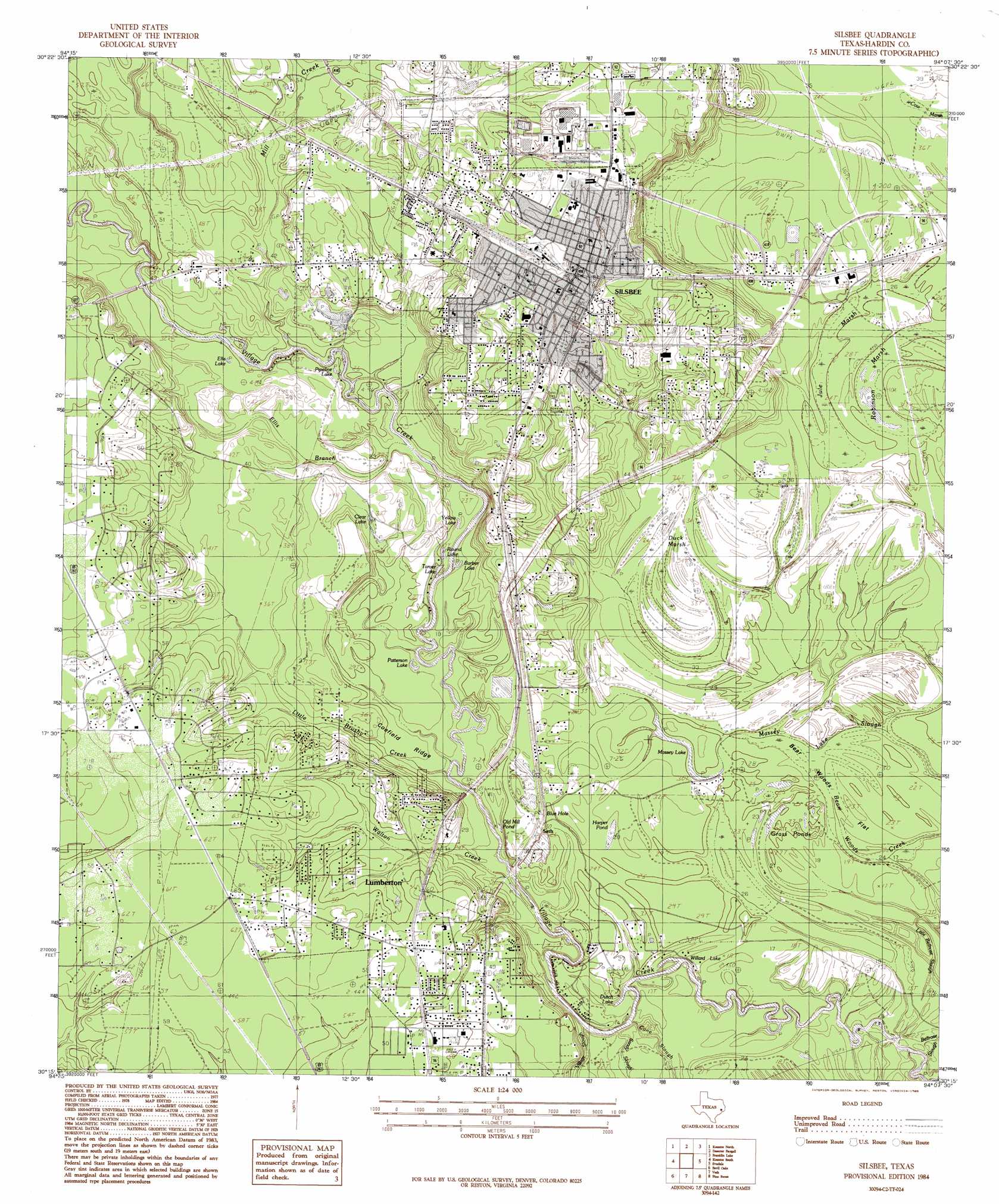
Silsbee Topo Map Texas
To zoom in, hover over the map of Silsbee
USGS Topo Quad 30094c2 - 1:24,000 scale
| Topo Map Name: | Silsbee |
| USGS Topo Quad ID: | 30094c2 |
| Print Size: | ca. 21 1/4" wide x 27" high |
| Southeast Coordinates: | 30.25° N latitude / 94.125° W longitude |
| Map Center Coordinates: | 30.3125° N latitude / 94.1875° W longitude |
| U.S. State: | TX |
| Filename: | o30094c2.jpg |
| Download Map JPG Image: | Silsbee topo map 1:24,000 scale |
| Map Type: | Topographic |
| Topo Series: | 7.5´ |
| Map Scale: | 1:24,000 |
| Source of Map Images: | United States Geological Survey (USGS) |
| Alternate Map Versions: |
Silsbee TX 1984, updated 1985 Download PDF Buy paper map Silsbee TX 1984, updated 1985 Download PDF Buy paper map Silsbee TX 2010 Download PDF Buy paper map Silsbee TX 2013 Download PDF Buy paper map Silsbee TX 2016 Download PDF Buy paper map |
1:24,000 Topo Quads surrounding Silsbee
Warren |
Hicksbaugh |
Fred |
Potato Patch Lake |
Call Junction |
Village Mills |
Kountze North |
Deserter Baygall |
Franklin Lake |
Buna |
Kountze Sw |
Kountze South |
Silsbee |
Evadale |
Gist |
Sour Lake |
Bevil Oaks |
Voth |
Pine Forest |
Texla |
Nome |
China |
Beaumont West |
Beaumont East |
Terry |
> Back to 30094a1 at 1:100,000 scale
> Back to 30094a1 at 1:250,000 scale
> Back to U.S. Topo Maps home
Silsbee topo map: Gazetteer
Silsbee: Flats
Bear Woods Flat elevation 7m 22′Silsbee: Guts
Bear Woods Creek elevation 5m 16′Massey Lake Slough elevation 6m 19′
Silsbee: Lakes
Blue Hole elevation 9m 29′Clear Lake elevation 11m 36′
Grass Ponds elevation 7m 22′
Massey Lake elevation 8m 26′
Old Mill Pond elevation 9m 29′
Patterson Lake elevation 5m 16′
Round Lake elevation 6m 19′
Willard Lake elevation 4m 13′
Yellow Lake elevation 6m 19′
Silsbee: Parks
Raider Stadium elevation 17m 55′Village Creek State Park elevation 5m 16′
Silsbee: Populated Places
Fletcher elevation 14m 45′Lumberton elevation 18m 59′
Seth elevation 11m 36′
Silsbee elevation 25m 82′
Silsbee: Reservoirs
Harper Pond elevation 8m 26′Silsbee: Springs
Meadows Springs elevation 14m 45′Silsbee: Streams
Cane Slough elevation 4m 13′Ellis Branch elevation 5m 16′
Mill Creek elevation 6m 19′
Sandy Slough elevation 2m 6′
Village Slough elevation 3m 9′
Walton Creek elevation 3m 9′
Silsbee: Swamps
Robinson Marsh elevation 7m 22′Silsbee: Trails
Roy E Larsen Sandyland Sanctuary Trail elevation 14m 45′Village Creek State Park Trail elevation 6m 19′
Silsbee digital topo map on disk
Buy this Silsbee topo map showing relief, roads, GPS coordinates and other geographical features, as a high-resolution digital map file on DVD: