Franklin Lake Topo Map Texas
To zoom in, hover over the map of Franklin Lake
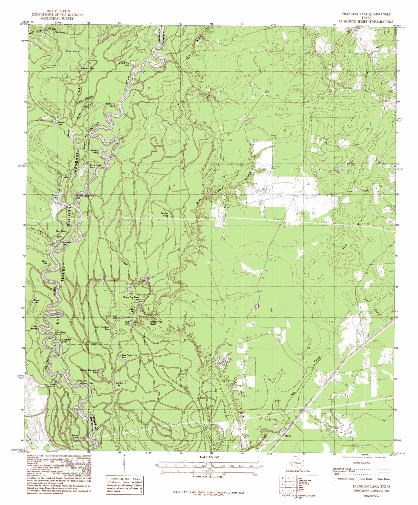
USGS Topo Quad 30094d1 - 1:24,000 scale
| Topo Map Name: | Franklin Lake |
| USGS Topo Quad ID: | 30094d1 |
| Print Size: | ca. 21 1/4" wide x 27" high |
| Southeast Coordinates: | 30.375° N latitude / 94° W longitude |
| Map Center Coordinates: | 30.4375° N latitude / 94.0625° W longitude |
| U.S. State: | TX |
| Filename: | o30094d1.jpg |
| Download Map JPG Image: | Franklin Lake topo map 1:24,000 scale |
| Map Type: | Topographic |
| Topo Series: | 7.5´ |
| Map Scale: | 1:24,000 |
| Source of Map Images: | United States Geological Survey (USGS) |
| Alternate Map Versions: |
Franklin Lake TX 1984, updated 1985 Download PDF Buy paper map Franklin Lake TX 1984, updated 1985 Download PDF Buy paper map Franklin Lake TX 2010 Download PDF Buy paper map Franklin Lake TX 2013 Download PDF Buy paper map Franklin Lake TX 2016 Download PDF Buy paper map |
1:24,000 Topo Quads surrounding Franklin Lake
Kirkpatrick Lake |
Spurger |
Magnolia Springs |
Kirbyville |
Bleakwood |
Hicksbaugh |
Fred |
Potato Patch Lake |
Call Junction |
Trout Creek |
Kountze North |
Deserter Baygall |
Franklin Lake |
Buna |
Sudduth Bluff |
Kountze South |
Silsbee |
Evadale |
Gist |
Hartburg |
Bevil Oaks |
Voth |
Pine Forest |
Texla |
Mauriceville |
> Back to 30094a1 at 1:100,000 scale
> Back to 30094a1 at 1:250,000 scale
> Back to U.S. Topo Maps home
Franklin Lake topo map: Gazetteer
Franklin Lake: Bends
Cocklebur Bend elevation 13m 42′Goatneck Bend elevation 9m 29′
Old Stove Bend elevation 9m 29′
Pearl River Bend elevation 7m 22′
Franklin Lake: Cliffs
Bear Mans Bluff elevation 13m 42′Oak Bluff elevation 19m 62′
Peach Tree Point elevation 9m 29′
Franklin Lake: Guts
Burnt Slough elevation 13m 42′Deep Slough elevation 10m 32′
Gum Slough elevation 17m 55′
Sand Slough elevation 9m 29′
Water Slough elevation 12m 39′
Franklin Lake: Lakes
Almond Hole elevation 6m 19′Ard Lake elevation 11m 36′
Bear Mans Lake elevation 8m 26′
Big Pine Hammock Lake elevation 8m 26′
Black Creek Lake elevation 9m 29′
Boat Lake elevation 8m 26′
Buck Lake elevation 8m 26′
Clear Lake elevation 8m 26′
Clear Lake elevation 12m 39′
Fish Lake elevation 9m 29′
Franklin Lake elevation 11m 36′
Heart Lake elevation 11m 36′
Johns Lake elevation 9m 29′
Lone Pine Ridge Lake elevation 8m 26′
Palmer Lake elevation 9m 29′
Peach Tree Point Lake elevation 8m 26′
Pool Stave Camp Lake elevation 8m 26′
Possum Lake elevation 11m 36′
Round Lake elevation 8m 26′
Shade Lake elevation 12m 39′
Shade Lake elevation 9m 29′
Side Pocket Lake elevation 8m 26′
Smith Lake elevation 7m 22′
Wheeler Cutoff Lake elevation 8m 26′
Franklin Lake: Parks
Big Thicket National Preserve elevation 10m 32′Franklin Lake: Populated Places
Gore Landing elevation 8m 26′Quinn elevation 15m 49′
Franklin Lake: Rapids
Gourd Vine Eddy elevation 11m 36′Franklin Lake: Streams
Black Creek elevation 8m 26′Bucks Branch elevation 18m 59′
Little Black Creek elevation 9m 29′
Sam Goode Branch elevation 8m 26′
Franklin Lake: Swamps
Big Marsh elevation 17m 55′Franklin Lake digital topo map on disk
Buy this Franklin Lake topo map showing relief, roads, GPS coordinates and other geographical features, as a high-resolution digital map file on DVD: