Hillister Topo Map Texas
To zoom in, hover over the map of Hillister
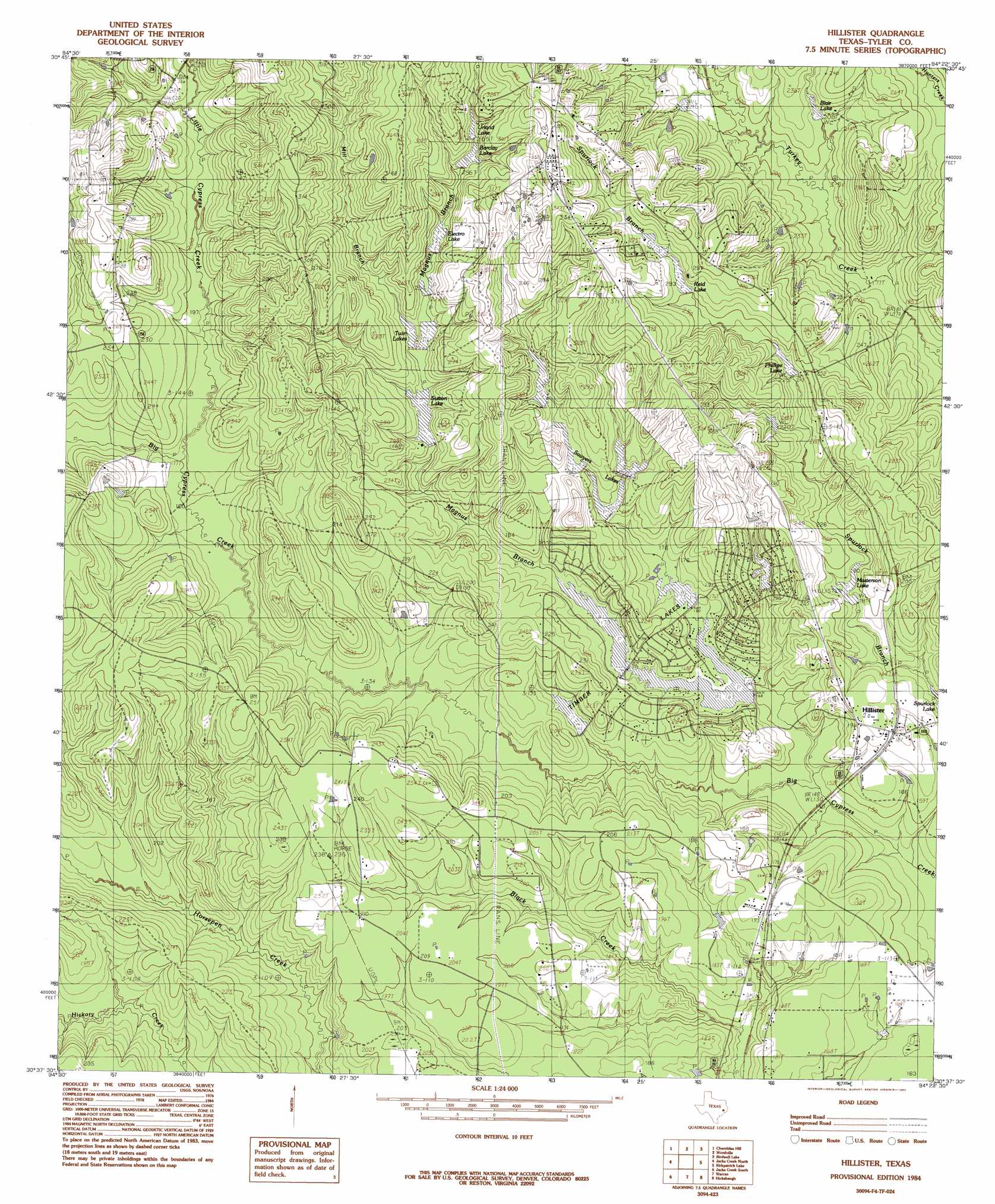
USGS Topo Quad 30094f4 - 1:24,000 scale
| Topo Map Name: | Hillister |
| USGS Topo Quad ID: | 30094f4 |
| Print Size: | ca. 21 1/4" wide x 27" high |
| Southeast Coordinates: | 30.625° N latitude / 94.375° W longitude |
| Map Center Coordinates: | 30.6875° N latitude / 94.4375° W longitude |
| U.S. State: | TX |
| Filename: | o30094f4.jpg |
| Download Map JPG Image: | Hillister topo map 1:24,000 scale |
| Map Type: | Topographic |
| Topo Series: | 7.5´ |
| Map Scale: | 1:24,000 |
| Source of Map Images: | United States Geological Survey (USGS) |
| Alternate Map Versions: |
Hillister TX 1984, updated 1985 Download PDF Buy paper map Hillister TX 2010 Download PDF Buy paper map Hillister TX 2013 Download PDF Buy paper map Hillister TX 2016 Download PDF Buy paper map |
1:24,000 Topo Quads surrounding Hillister
Camden |
Chester |
Colmesneil |
Boggy Lake |
Pace Hill |
Hortense |
Chambliss Hill |
Woodville |
Birdwell Lake |
Town Bluff |
Dallardsville |
Jacks Creek North |
Hillister |
Kirkpatrick Lake |
Spurger |
Segno |
Jacks Creek South |
Warren |
Hicksbaugh |
Fred |
Votaw |
Bragg |
Village Mills |
Kountze North |
Deserter Baygall |
> Back to 30094e1 at 1:100,000 scale
> Back to 30094a1 at 1:250,000 scale
> Back to U.S. Topo Maps home
Hillister topo map: Gazetteer
Hillister: Airports
Cow Pasture Airport elevation 50m 164′Hillister: Dams
Barclay Lake Dam elevation 77m 252′Boykin Lake Dam Number 1 elevation 67m 219′
Boykin Lake Number 2 Dam elevation 67m 219′
Clemmons Lake Dam elevation 79m 259′
East Sawyers Dam elevation 64m 209′
Electro Lake Dam elevation 70m 229′
Lake Camelot Dam elevation 46m 150′
Lake Charmaine Dam elevation 49m 160′
Lake Galahad Dam elevation 52m 170′
Lake Ivanhoe Dam elevation 62m 203′
Lake Tristan Dam elevation 55m 180′
Masterson Lake Dam elevation 55m 180′
Phillips Lake Dam elevation 67m 219′
South Sawyers Dam elevation 58m 190′
Spurlock Branch Reservoir Dam elevation 79m 259′
Sutton Lake Dam elevation 61m 200′
Twin Lakes Dam elevation 67m 219′
West Sawyers Dam elevation 63m 206′
Hillister: Populated Places
Hillister elevation 58m 190′Hillister: Reservoirs
Barclay Lake elevation 76m 249′Blair Lake elevation 62m 203′
Boykin Lake Number 1 elevation 67m 219′
Boykin Lake Number 2 elevation 67m 219′
Clemmons Lake elevation 79m 259′
East Sawyers Lake elevation 64m 209′
Electro Lake elevation 68m 223′
Lake Camelot elevation 46m 150′
Lake Charmaine elevation 49m 160′
Lake Galahad elevation 52m 170′
Lake Ivanhoe elevation 62m 203′
Lake Tristan elevation 55m 180′
Masterson Lake elevation 55m 180′
Phillips Lake elevation 67m 219′
Reid Lake elevation 76m 249′
Sawyers Lakes elevation 58m 190′
South Sawyers Lake elevation 58m 190′
Spurlock Branch Reservoir elevation 79m 259′
Sutton Lake elevation 61m 200′
Timber Lakes elevation 52m 170′
Twin Lakes elevation 65m 213′
Urland Lake elevation 80m 262′
West Sawyers Lake elevation 63m 206′
Hillister: Streams
Little Cypress Creek elevation 54m 177′Magnus Branch elevation 40m 131′
Spurlock Branch elevation 38m 124′
Hillister digital topo map on disk
Buy this Hillister topo map showing relief, roads, GPS coordinates and other geographical features, as a high-resolution digital map file on DVD: