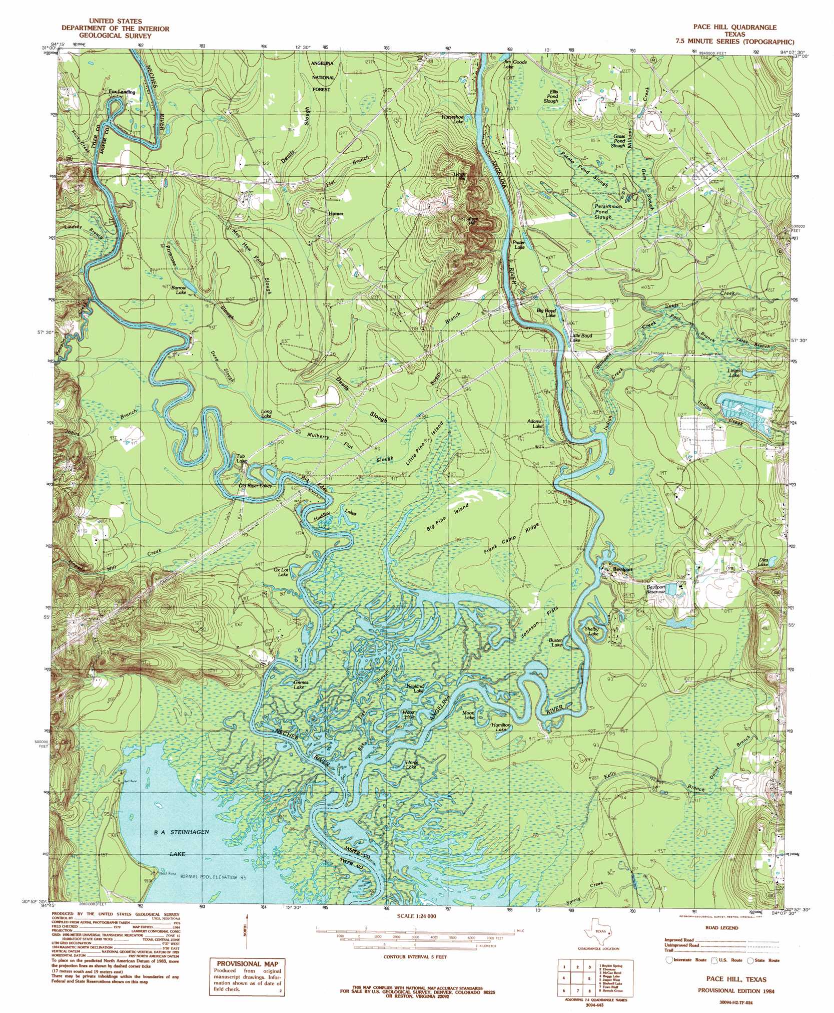
Pace Hill Topo Map Texas
To zoom in, hover over the map of Pace Hill
USGS Topo Quad 30094h2 - 1:24,000 scale
| Topo Map Name: | Pace Hill |
| USGS Topo Quad ID: | 30094h2 |
| Print Size: | ca. 21 1/4" wide x 27" high |
| Southeast Coordinates: | 30.875° N latitude / 94.125° W longitude |
| Map Center Coordinates: | 30.9375° N latitude / 94.1875° W longitude |
| U.S. State: | TX |
| Filename: | o30094h2.jpg |
| Download Map JPG Image: | Pace Hill topo map 1:24,000 scale |
| Map Type: | Topographic |
| Topo Series: | 7.5´ |
| Map Scale: | 1:24,000 |
| Source of Map Images: | United States Geological Survey (USGS) |
| Alternate Map Versions: |
Pace Hill TX 1984, updated 1985 Download PDF Buy paper map Pace Hill TX 1984, updated 1985 Download PDF Buy paper map Pace Hill TX 2003, updated 2004 Download PDF Buy paper map Pace Hill TX 2010 Download PDF Buy paper map Pace Hill TX 2013 Download PDF Buy paper map Pace Hill TX 2016 Download PDF Buy paper map |
| FStopo: | US Forest Service topo Pace Hill is available: Download FStopo PDF Download FStopo TIF |
1:24,000 Topo Quads surrounding Pace Hill
Zavalla |
Cassells-Boykin Park |
Veach |
Buck Bay |
Pineland South |
Rockland |
Boykin Spring |
Ebenezer |
Mcgee Bend |
Harrisburg |
Colmesneil |
Boggy Lake |
Pace Hill |
Jasper West |
Jasper East |
Woodville |
Birdwell Lake |
Town Bluff |
Beech Grove |
Roganville |
Hillister |
Kirkpatrick Lake |
Spurger |
Magnolia Springs |
Kirbyville |
> Back to 30094e1 at 1:100,000 scale
> Back to 30094a1 at 1:250,000 scale
> Back to U.S. Topo Maps home
Pace Hill topo map: Gazetteer
Pace Hill: Airports
TGP 32 Heliport elevation 37m 121′Pace Hill: Dams
Lingo Lake Dam elevation 35m 114′Pace Hill: Flats
Johnson Flats elevation 28m 91′Pace Hill: Guts
Mulberry Flat Slough elevation 27m 88′Pace Hill: Islands
Big Pine Island elevation 27m 88′Little Pine Island elevation 26m 85′
Pace Hill: Lakes
Adams Lake elevation 30m 98′BA Steinhagen Lake elevation 25m 82′
Barrow Lake elevation 26m 85′
Big Boyd Lake elevation 33m 108′
Big Eddy elevation 26m 85′
Buster Lake elevation 28m 91′
Dies Lake elevation 42m 137′
Grimes Lake elevation 26m 85′
Hamilton Lake elevation 27m 88′
Horse Lake elevation 26m 85′
Horseshoe Lake elevation 26m 85′
Huddley Lakes elevation 27m 88′
Jim Goode Lake elevation 30m 98′
Lingo Lake elevation 34m 111′
Little Boyd Lake elevation 32m 104′
Long Lake elevation 27m 88′
Moon Lake elevation 26m 85′
Neyland Lake elevation 25m 82′
Old River Lakes elevation 25m 82′
Ox Lot Lake elevation 26m 85′
Prater Lake elevation 32m 104′
Shelby Lake elevation 25m 82′
Tub Lake elevation 27m 88′
Wash Lake elevation 28m 91′
Water Hole elevation 25m 82′
Pace Hill: Parks
Bevelport Townsite Historical Monument elevation 33m 108′Doctor Steven H Everitt Historical Monument elevation 53m 173′
State Wildlife Scientific Area elevation 27m 88′
State Wildlife Scientific Area elevation 26m 85′
Pace Hill: Populated Places
Bevilport elevation 30m 98′Fox Landing elevation 30m 98′
Homer elevation 37m 121′
Pace Hill: Reservoirs
Bevelport Reservoir elevation 33m 108′Lingo Lake elevation 35m 114′
Pace Hill: Ridges
Frank Camp Ridge elevation 28m 91′Pace Hill: Streams
Angelina River elevation 25m 82′Boggy Branch elevation 27m 88′
Dallas Branch elevation 28m 91′
Deep Slough elevation 27m 88′
Devils Slough elevation 29m 95′
Flat Branch elevation 31m 101′
Hopson Mill Creek elevation 25m 82′
Indian Creek elevation 26m 85′
Johns Branch elevation 25m 82′
Kelly Branch elevation 26m 85′
Lindsey Branch elevation 25m 82′
Louis Creek elevation 29m 95′
May Haw Pond Slough elevation 27m 88′
Pamplin Creek elevation 25m 82′
Pool Branch elevation 30m 98′
Primrose Slough elevation 27m 88′
Rocky Creek elevation 25m 82′
Spring Creek elevation 26m 85′
Williams Creek elevation 29m 95′
Yates Branch elevation 32m 104′
Pace Hill: Summits
Lynch Hill elevation 45m 147′Pace Hill elevation 72m 236′
Pace Hill: Swamps
Bee Tree Swamp elevation 27m 88′Ellis Pond Slough elevation 32m 104′
Grass Pond Slough elevation 32m 104′
Gum Slough elevation 32m 104′
Persimmon Pond Slough elevation 30m 98′
Potato Pond Slough elevation 30m 98′
Pace Hill: Trails
Old River Woodland Trail elevation 28m 91′Pace Hill: Woods
Pine Woods elevation 27m 88′Pace Hill digital topo map on disk
Buy this Pace Hill topo map showing relief, roads, GPS coordinates and other geographical features, as a high-resolution digital map file on DVD: