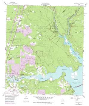
Moonshine Hill Topo Map Texas
To zoom in, hover over the map of Moonshine Hill
USGS Topo Quad 30095a2 - 1:24,000 scale
| Topo Map Name: | Moonshine Hill |
| USGS Topo Quad ID: | 30095a2 |
| Print Size: | ca. 21 1/4" wide x 27" high |
| Southeast Coordinates: | 30° N latitude / 95.125° W longitude |
| Map Center Coordinates: | 30.0625° N latitude / 95.1875° W longitude |
| U.S. State: | TX |
| Filename: | o30095a2.jpg |
| Download Map JPG Image: | Moonshine Hill topo map 1:24,000 scale |
| Map Type: | Topographic |
| Topo Series: | 7.5´ |
| Map Scale: | 1:24,000 |
| Source of Map Images: | United States Geological Survey (USGS) |
| Alternate Map Versions: |
Moonshine Hill TX 1916 Download PDF Buy paper map Moonshine Hill TX 1916 Download PDF Buy paper map Moonshine Hill TX 1916, updated 1955 Download PDF Buy paper map Moonshine Hill TX 1961, updated 1962 Download PDF Buy paper map Moonshine Hill TX 1961, updated 1962 Download PDF Buy paper map Moonshine Hill TX 1961, updated 1980 Download PDF Buy paper map Moonshine Hill TX 1961, updated 1987 Download PDF Buy paper map Moonshine Hill TX 1995, updated 2000 Download PDF Buy paper map Moonshine Hill TX 2010 Download PDF Buy paper map Moonshine Hill TX 2013 Download PDF Buy paper map Moonshine Hill TX 2016 Download PDF Buy paper map |
1:24,000 Topo Quads surrounding Moonshine Hill
> Back to 30095a1 at 1:100,000 scale
> Back to 30094a1 at 1:250,000 scale
> Back to U.S. Topo Maps home
Moonshine Hill topo map: Gazetteer
Moonshine Hill: Bridges
McKay Bridge elevation 14m 45′Moonshine Hill: Guts
Artesian Slough elevation 24m 78′Moonshine Hill: Lakes
Bosman Lake elevation 15m 49′Browns Lake elevation 26m 85′
Ford Lake elevation 24m 78′
Isabell Lake elevation 17m 55′
Shadow Lake elevation 30m 98′
Ten Acre Lake elevation 23m 75′
Moonshine Hill: Parks
Deer Ridge Park elevation 15m 49′Lake Houston State Park elevation 20m 65′
New Caney Stadium elevation 31m 101′
North Park Recreation Area elevation 24m 78′
River Grove Park elevation 14m 45′
Moonshine Hill: Populated Places
Adams Oaks elevation 28m 91′Atascocita North elevation 21m 68′
Atascocita West elevation 22m 72′
Bear Branch Village elevation 23m 75′
Belleau Wood elevation 16m 52′
Dogwood Acres elevation 17m 55′
Dunnam elevation 21m 68′
Elm Grove Village elevation 23m 75′
Greentree Village elevation 23m 75′
Hunter Ridge Village elevation 20m 65′
Kings Forest elevation 18m 59′
Moonshine Hill elevation 21m 68′
North Shore elevation 15m 49′
Oak Terrace elevation 26m 85′
Oaks of Atascocita elevation 21m 68′
Pinehurst of Atascocita elevation 21m 68′
Pines of Atascocita elevation 15m 49′
Pittsville elevation 25m 82′
Porter elevation 31m 101′
River Terrace elevation 22m 72′
Riverside Crest elevation 14m 45′
Shadow Lake Estates elevation 29m 95′
Sherwood Trails Village elevation 22m 72′
Timberlane Acres elevation 25m 82′
Walden Woods elevation 14m 45′
Woodland Hills Village elevation 24m 78′
Moonshine Hill: Ridges
Black Cat Ridge elevation 25m 82′Moonshine Hill: Streams
Bens Branch elevation 13m 42′Caney Creek elevation 14m 45′
East Fork San Jacinto River elevation 13m 42′
Mills Branch elevation 15m 49′
Peach Creek elevation 14m 45′
West Fork San Jacinto River elevation 13m 42′
White Oak Creek elevation 13m 42′
Moonshine Hill: Swamps
Eagle Pond elevation 23m 75′Grassy Pond elevation 24m 78′
League Ponds elevation 27m 88′
Long Pond elevation 24m 78′
Maple Slough elevation 23m 75′
McAlhany Pond elevation 28m 91′
Odom Pond elevation 23m 75′
Panther Pond elevation 23m 75′
Pauli Pond elevation 25m 82′
Perkins Pond elevation 32m 104′
Pew Pond elevation 30m 98′
Round Pew Pond elevation 30m 98′
Round Pond elevation 30m 98′
Wagner Pond elevation 25m 82′
Whiskey Still Pond elevation 23m 75′
Moonshine Hill: Valleys
Blackland Gully elevation 14m 45′Jordon Gully elevation 13m 42′
Robinson Gully elevation 18m 59′
Rockpool Gully elevation 14m 45′
Taylor Gully elevation 14m 45′
Moonshine Hill digital topo map on disk
Buy this Moonshine Hill topo map showing relief, roads, GPS coordinates and other geographical features, as a high-resolution digital map file on DVD:


