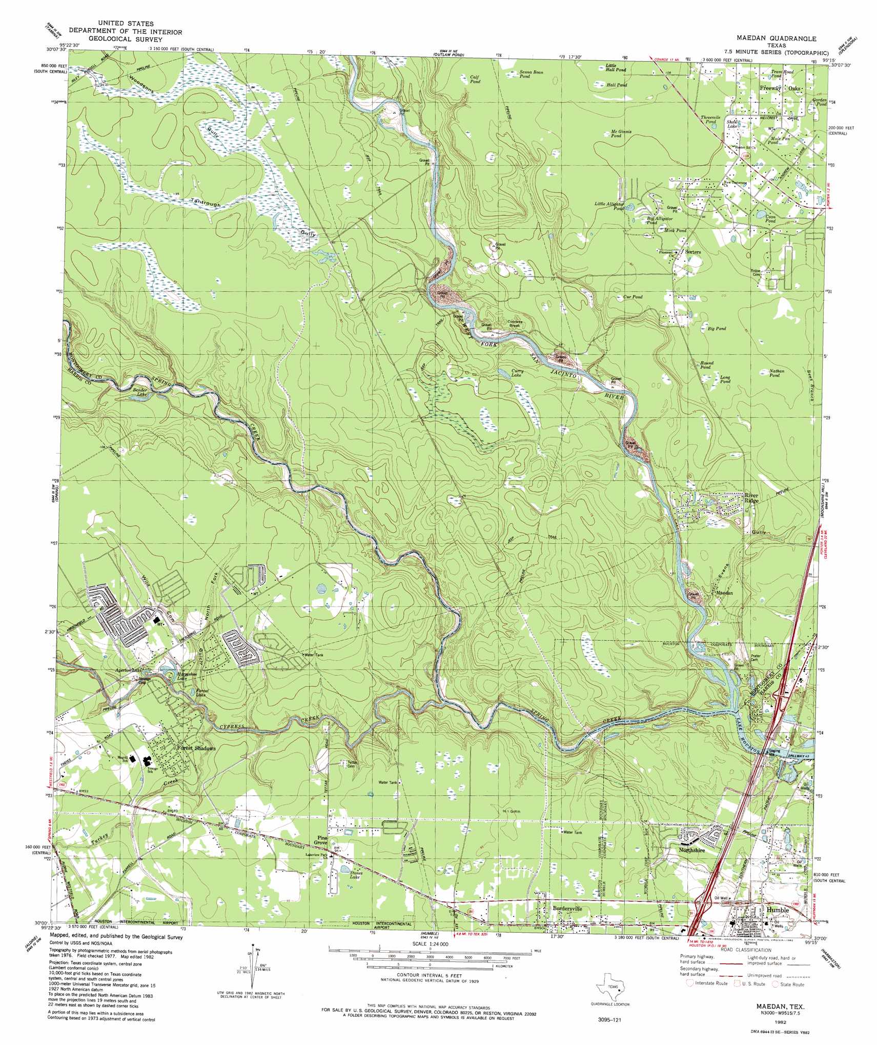
Maedan Topo Map Texas
To zoom in, hover over the map of Maedan
USGS Topo Quad 30095a3 - 1:24,000 scale
| Topo Map Name: | Maedan |
| USGS Topo Quad ID: | 30095a3 |
| Print Size: | ca. 21 1/4" wide x 27" high |
| Southeast Coordinates: | 30° N latitude / 95.25° W longitude |
| Map Center Coordinates: | 30.0625° N latitude / 95.3125° W longitude |
| U.S. State: | TX |
| Filename: | o30095a3.jpg |
| Download Map JPG Image: | Maedan topo map 1:24,000 scale |
| Map Type: | Topographic |
| Topo Series: | 7.5´ |
| Map Scale: | 1:24,000 |
| Source of Map Images: | United States Geological Survey (USGS) |
| Alternate Map Versions: |
Maedan TX 1961, updated 1962 Download PDF Buy paper map Maedan TX 1961, updated 1962 Download PDF Buy paper map Maedan TX 1982, updated 1982 Download PDF Buy paper map Maedan TX 1995, updated 1999 Download PDF Buy paper map Maedan TX 2010 Download PDF Buy paper map Maedan TX 2013 Download PDF Buy paper map Maedan TX 2016 Download PDF Buy paper map |
1:24,000 Topo Quads surrounding Maedan
Cowl Spur |
Conroe |
Cut And Shoot |
Fostoria |
Cleveland |
Oklahoma |
Tamina |
Outlaw Pond |
Splendora |
Plum Grove |
Tomball |
Spring |
Maedan |
Moonshine Hill |
Huffman |
Satsuma |
Aldine |
Humble |
Harmaston |
Crosby |
Hedwig Village |
Houston Heights |
Settegast |
Jacinto City |
Highlands |
> Back to 30095a1 at 1:100,000 scale
> Back to 30094a1 at 1:250,000 scale
> Back to U.S. Topo Maps home
Maedan topo map: Gazetteer
Maedan: Bridges
State Highway 35 Bridge elevation 13m 42′Maedan: Parks
Charles Street Stadium elevation 27m 88′Jesse H Jones County Park elevation 18m 59′
San Jacinto Park elevation 15m 49′
Maedan: Populated Places
Birnham Wood elevation 31m 101′Bordersville elevation 29m 95′
Foxwood elevation 29m 95′
Greengate Place elevation 29m 95′
Kenswick elevation 29m 95′
Kingwood elevation 15m 49′
Millcreek elevation 29m 95′
Post Wood elevation 30m 98′
River Club Estates elevation 21m 68′
Sandpiper elevation 31m 101′
Sandpiper Village elevation 27m 88′
Maedan: Streams
Cypress Creek elevation 14m 45′Spring Creek elevation 13m 42′
Turkey Creek elevation 17m 55′
Maedan: Trails
Jesse H Jones Park and Nature Center Trail elevation 27m 88′Maedan: Valleys
Woodsons Gully elevation 29m 95′Maedan digital topo map on disk
Buy this Maedan topo map showing relief, roads, GPS coordinates and other geographical features, as a high-resolution digital map file on DVD: