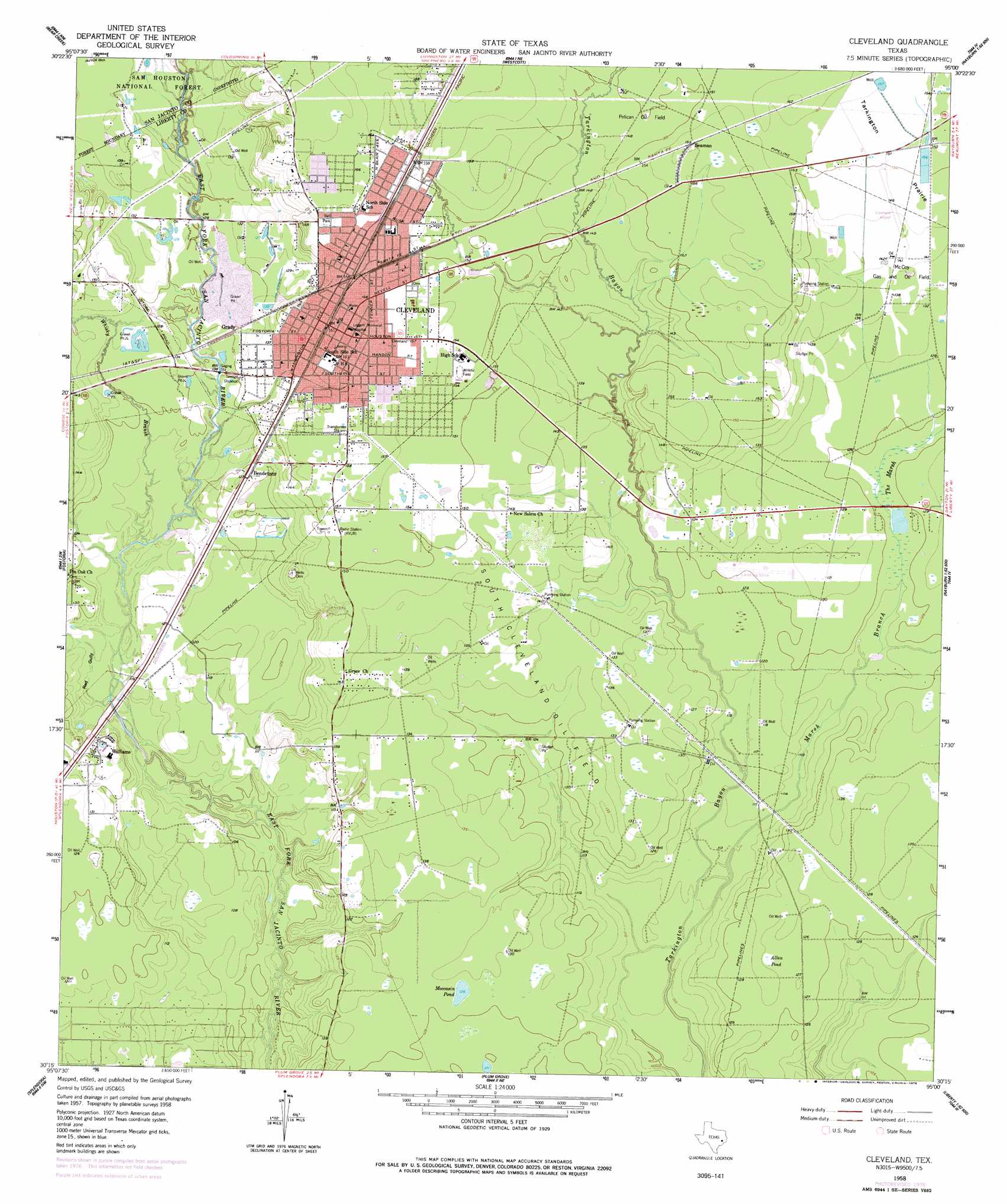
Cleveland Topo Map Texas
To zoom in, hover over the map of Cleveland
USGS Topo Quad 30095c1 - 1:24,000 scale
| Topo Map Name: | Cleveland |
| USGS Topo Quad ID: | 30095c1 |
| Print Size: | ca. 21 1/4" wide x 27" high |
| Southeast Coordinates: | 30.25° N latitude / 95° W longitude |
| Map Center Coordinates: | 30.3125° N latitude / 95.0625° W longitude |
| U.S. State: | TX |
| Filename: | o30095c1.jpg |
| Download Map JPG Image: | Cleveland topo map 1:24,000 scale |
| Map Type: | Topographic |
| Topo Series: | 7.5´ |
| Map Scale: | 1:24,000 |
| Source of Map Images: | United States Geological Survey (USGS) |
| Alternate Map Versions: |
Cleveland TX 1958, updated 1959 Download PDF Buy paper map Cleveland TX 1958, updated 1978 Download PDF Buy paper map Cleveland TX 1997, updated 2000 Download PDF Buy paper map Cleveland TX 2010 Download PDF Buy paper map Cleveland TX 2013 Download PDF Buy paper map Cleveland TX 2016 Download PDF Buy paper map |
| FStopo: | US Forest Service topo Cleveland is available: Download FStopo PDF Download FStopo TIF |
1:24,000 Topo Quads surrounding Cleveland
Maynard |
Coldspring |
Camilla |
Goodrich |
Schwab City |
Conroe Ne |
Bear Creek |
Westcott |
Rayburn |
Romayor |
Cut And Shoot |
Fostoria |
Cleveland |
Tarkington Prairie |
Davis Hill |
Outlaw Pond |
Splendora |
Plum Grove |
Simmons Bottom |
Capers Ridge |
Maedan |
Moonshine Hill |
Huffman |
Dayton |
Liberty |
> Back to 30095a1 at 1:100,000 scale
> Back to 30094a1 at 1:250,000 scale
> Back to U.S. Topo Maps home
Cleveland topo map: Gazetteer
Cleveland: Airports
Ainsworth Airport elevation 38m 124′Cleveland Municipal Airport elevation 44m 144′
Cleveland: Lakes
Moccasin Pond elevation 38m 124′Cleveland: Oilfields
McCoy Gas and Oil Field elevation 42m 137′Pelican Oil Field elevation 45m 147′
South Cleveland Oil Field elevation 39m 127′
Cleveland: Parks
Stancil Park elevation 47m 154′Cleveland: Populated Places
Ainsworth elevation 39m 127′Bendetsen elevation 39m 127′
Cleveland elevation 48m 157′
Gladstell elevation 32m 104′
Grace elevation 44m 144′
Grady elevation 39m 127′
Nimrod elevation 37m 121′
Pelican elevation 48m 157′
Seaman elevation 49m 160′
Snuff Ridge elevation 44m 144′
Williams elevation 40m 131′
Cleveland: Streams
Marsh Branch elevation 32m 104′Whisky Branch elevation 33m 108′
Cleveland: Swamps
Allan Pond elevation 39m 127′The Marsh elevation 38m 124′
Cleveland: Valleys
Red Gully elevation 32m 104′Cleveland digital topo map on disk
Buy this Cleveland topo map showing relief, roads, GPS coordinates and other geographical features, as a high-resolution digital map file on DVD: