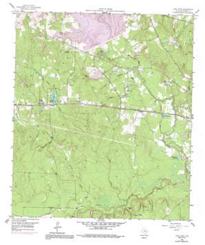
Cowl Spur Topo Map Texas
To zoom in, hover over the map of Cowl Spur
USGS Topo Quad 30095c5 - 1:24,000 scale
| Topo Map Name: | Cowl Spur |
| USGS Topo Quad ID: | 30095c5 |
| Print Size: | ca. 21 1/4" wide x 27" high |
| Southeast Coordinates: | 30.25° N latitude / 95.5° W longitude |
| Map Center Coordinates: | 30.3125° N latitude / 95.5625° W longitude |
| U.S. State: | TX |
| Filename: | o30095c5.jpg |
| Download Map JPG Image: | Cowl Spur topo map 1:24,000 scale |
| Map Type: | Topographic |
| Topo Series: | 7.5´ |
| Map Scale: | 1:24,000 |
| Source of Map Images: | United States Geological Survey (USGS) |
| Alternate Map Versions: |
Cowl Spur TX 1958, updated 1959 Download PDF Buy paper map Cowl Spur TX 1958, updated 1969 Download PDF Buy paper map Cowl Spur TX 1958, updated 1978 Download PDF Buy paper map Cowl Spur TX 1958, updated 1991 Download PDF Buy paper map Cowl Spur TX 2010 Download PDF Buy paper map Cowl Spur TX 2013 Download PDF Buy paper map Cowl Spur TX 2016 Download PDF Buy paper map |
1:24,000 Topo Quads surrounding Cowl Spur
> Back to 30095a1 at 1:100,000 scale
> Back to 30094a1 at 1:250,000 scale
> Back to U.S. Topo Maps home
Cowl Spur topo map: Gazetteer
Cowl Spur: Airports
Lake Bonanza Airport elevation 89m 291′Cowl Spur: Dams
Artesian Lake Dam elevation 40m 131′Conroe Dam elevation 44m 144′
Country Club Lake Dam elevation 51m 167′
Fish Creek Dam elevation 73m 239′
Hickory Lake Dam elevation 71m 232′
Lake Bonanza Dam elevation 67m 219′
Lake Conroe Forest Dam elevation 65m 213′
Lake Forest Falls Dam elevation 54m 177′
Rushing Springs Lake Dam elevation 69m 226′
Stone Branch Lake Dam elevation 47m 154′
Cowl Spur: Guts
Contrary Lake elevation 38m 124′Cowl Spur: Lakes
Magnolia Lake elevation 48m 157′Pevehouse Lake elevation 40m 131′
Cowl Spur: Oilfields
Lake Creek Oil Field elevation 60m 196′West Conroe Oil Field elevation 62m 203′
Cowl Spur: Populated Places
Honea elevation 75m 246′Leonidas elevation 49m 160′
Cowl Spur: Reservoirs
Artesian Lake elevation 40m 131′Country Club Lake elevation 51m 167′
Hickory Lake elevation 71m 232′
Lake Bonanza elevation 67m 219′
Lake Conroe elevation 66m 216′
Lake Forest elevation 70m 229′
Lake Forest Falls elevation 54m 177′
Rushing Springs Lake elevation 69m 226′
Scott Lake elevation 41m 134′
Stone Branch Lake elevation 47m 154′
Cowl Spur: Streams
Base Creek elevation 44m 144′East Fork White Oak Creek elevation 56m 183′
Egypt Creek elevation 39m 127′
Fish Creek elevation 37m 121′
Goat Ranch Branch elevation 54m 177′
Mound Creek elevation 41m 134′
Rush Creek elevation 62m 203′
Sand Branch elevation 40m 131′
Stowe Branch elevation 42m 137′
West Fork White Oak Creek elevation 56m 183′
White Oak Creek elevation 37m 121′
Cowl Spur digital topo map on disk
Buy this Cowl Spur topo map showing relief, roads, GPS coordinates and other geographical features, as a high-resolution digital map file on DVD:


