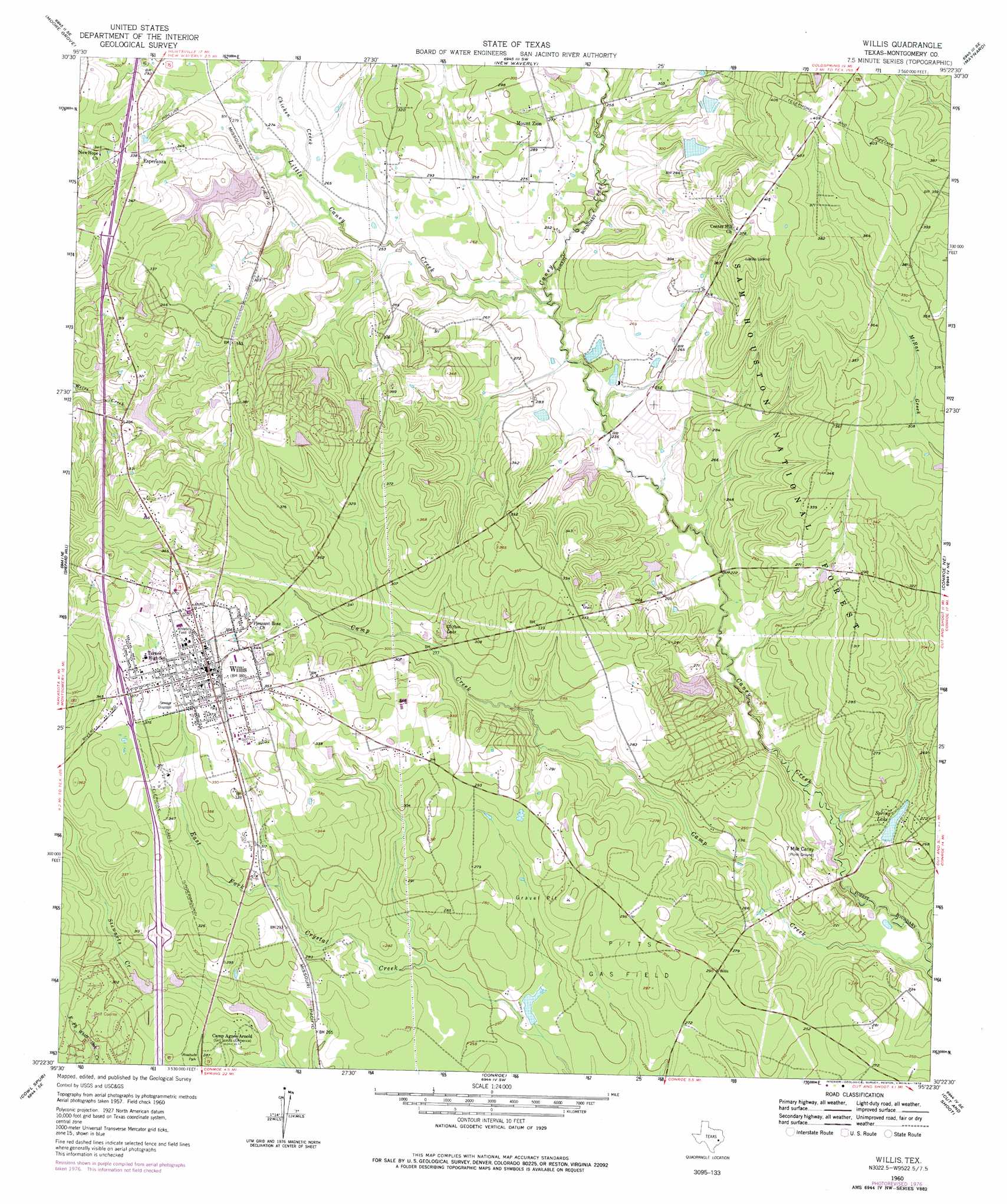
Willis Topo Map Texas
To zoom in, hover over the map of Willis
USGS Topo Quad 30095d4 - 1:24,000 scale
| Topo Map Name: | Willis |
| USGS Topo Quad ID: | 30095d4 |
| Print Size: | ca. 21 1/4" wide x 27" high |
| Southeast Coordinates: | 30.375° N latitude / 95.375° W longitude |
| Map Center Coordinates: | 30.4375° N latitude / 95.4375° W longitude |
| U.S. State: | TX |
| Filename: | o30095d4.jpg |
| Download Map JPG Image: | Willis topo map 1:24,000 scale |
| Map Type: | Topographic |
| Topo Series: | 7.5´ |
| Map Scale: | 1:24,000 |
| Source of Map Images: | United States Geological Survey (USGS) |
| Alternate Map Versions: |
Willis TX 1960, updated 1961 Download PDF Buy paper map Willis TX 1960, updated 1968 Download PDF Buy paper map Willis TX 1960, updated 1978 Download PDF Buy paper map Willis TX 1997, updated 2000 Download PDF Buy paper map Willis TX 2010 Download PDF Buy paper map Willis TX 2013 Download PDF Buy paper map Willis TX 2016 Download PDF Buy paper map |
| FStopo: | US Forest Service topo Willis is available: Download FStopo PDF Download FStopo TIF |
1:24,000 Topo Quads surrounding Willis
Galilee |
Huntsville |
Phelps |
Oakhurst |
Stephen Creek |
San Jacinto |
Moore Grove |
New Waverly |
Maynard |
Coldspring |
Montgomery |
Shepard Hill |
Willis |
Conroe Ne |
Bear Creek |
Keenan |
Cowl Spur |
Conroe |
Cut And Shoot |
Fostoria |
Magnolia East |
Oklahoma |
Tamina |
Outlaw Pond |
Splendora |
> Back to 30095a1 at 1:100,000 scale
> Back to 30094a1 at 1:250,000 scale
> Back to U.S. Topo Maps home
Willis topo map: Gazetteer
Willis: Dams
Dunwoody Lake Dam elevation 87m 285′Farrells Lake Dam elevation 74m 242′
Fish Lake Dam elevation 94m 308′
Frontier Lake Dam elevation 114m 374′
Hillside Lake Dam elevation 75m 246′
Lake Arrowhead Number 2 Dam elevation 96m 314′
Lake Arrowhead Number 3 Dam elevation 94m 308′
Moose Jaw Lake Dam elevation 89m 291′
Panorama Lake Dam elevation 81m 265′
Price Lake Dam elevation 70m 229′
Royal Forest Lake Dam elevation 73m 239′
Selden Lake Dam elevation 83m 272′
Shadow Lake Dam elevation 76m 249′
Spring Lake Dam elevation 68m 223′
Willis: Oilfields
Pitts Gas Field elevation 87m 285′Pitts Gas Field elevation 87m 285′
Willis: Populated Places
Ada elevation 102m 334′Esperanza elevation 104m 341′
Mount Zion elevation 83m 272′
Panorama Village elevation 93m 305′
Willis elevation 116m 380′
Willis: Reservoirs
Arrowead Lake elevation 99m 324′Clifton Clde elevation 87m 285′
Clifton Lake elevation 87m 285′
Dunwoody Lake elevation 87m 285′
Farrells Lake elevation 74m 242′
Fish Lake elevation 94m 308′
Frontier Lake elevation 114m 374′
Hillside Lake elevation 75m 246′
Lake Arrowhead Number 2 elevation 96m 314′
Lake Arrowhead Number 3 elevation 94m 308′
Panorama Lake elevation 81m 265′
Price Lake elevation 70m 229′
Royal Forest Lake elevation 73m 239′
Selden Lake elevation 83m 272′
Shadow Lake elevation 76m 249′
Spring Lake elevation 68m 223′
Willis: Streams
Camp Creek elevation 58m 190′Chicken Creek elevation 77m 252′
Chicken Creek elevation 79m 259′
Little Caney Creek elevation 70m 229′
Little Caney Creek elevation 70m 229′
Stewarts Creek elevation 81m 265′
Willis digital topo map on disk
Buy this Willis topo map showing relief, roads, GPS coordinates and other geographical features, as a high-resolution digital map file on DVD: