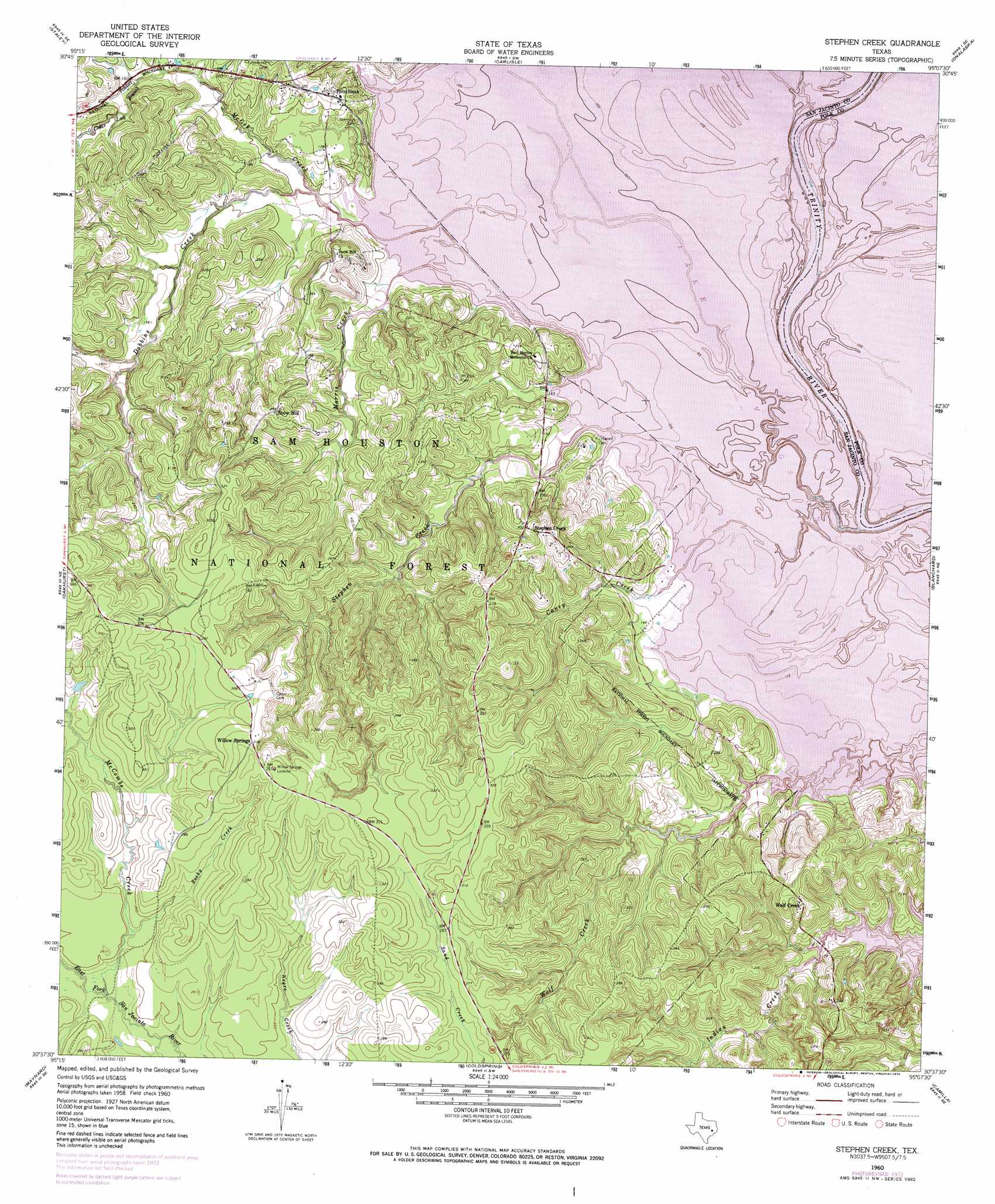
Stephen Creek Topo Map Texas
To zoom in, hover over the map of Stephen Creek
USGS Topo Quad 30095f2 - 1:24,000 scale
| Topo Map Name: | Stephen Creek |
| USGS Topo Quad ID: | 30095f2 |
| Print Size: | ca. 21 1/4" wide x 27" high |
| Southeast Coordinates: | 30.625° N latitude / 95.125° W longitude |
| Map Center Coordinates: | 30.6875° N latitude / 95.1875° W longitude |
| U.S. State: | TX |
| Filename: | o30095f2.jpg |
| Download Map JPG Image: | Stephen Creek topo map 1:24,000 scale |
| Map Type: | Topographic |
| Topo Series: | 7.5´ |
| Map Scale: | 1:24,000 |
| Source of Map Images: | United States Geological Survey (USGS) |
| Alternate Map Versions: |
Stephen Creek TX 1960, updated 1962 Download PDF Buy paper map Stephen Creek TX 1960, updated 1969 Download PDF Buy paper map Stephen Creek TX 1960, updated 1974 Download PDF Buy paper map Stephen Creek TX 1997, updated 2000 Download PDF Buy paper map Stephen Creek TX 2010 Download PDF Buy paper map Stephen Creek TX 2013 Download PDF Buy paper map Stephen Creek TX 2016 Download PDF Buy paper map |
| FStopo: | US Forest Service topo Stephen Creek is available: Download FStopo PDF Download FStopo TIF |
1:24,000 Topo Quads surrounding Stephen Creek
Trinity West |
Trinity East |
Chita |
Colita |
Carmona |
Riverside |
Staley |
Carlisle |
Onalaska |
New Willard |
Phelps |
Oakhurst |
Stephen Creek |
Blanchard |
Livingston |
New Waverly |
Maynard |
Coldspring |
Camilla |
Goodrich |
Willis |
Conroe Ne |
Bear Creek |
Westcott |
Rayburn |
> Back to 30095e1 at 1:100,000 scale
> Back to 30094a1 at 1:250,000 scale
> Back to U.S. Topo Maps home
Stephen Creek topo map: Gazetteer
Stephen Creek: Dams
Woodlands Golf Course Lake Dam elevation 43m 141′Stephen Creek: Parks
Wolf Creek Park elevation 57m 187′Stephen Creek: Populated Places
Pointblank elevation 66m 216′Snow Hill elevation 86m 282′
Stephen Creek elevation 71m 232′
Willow Springs elevation 97m 318′
Wolf Creek elevation 76m 249′
Stephen Creek: Reservoirs
Woodlands Golf Course Lake elevation 43m 141′Stephen Creek: Streams
Big Spring Creek elevation 40m 131′Caney Creek elevation 40m 131′
Cedar Lick Branch elevation 56m 183′
Dobbins Creek elevation 40m 131′
McCombs Creek elevation 70m 229′
McCombs Creek elevation 70m 229′
McGee Creek elevation 40m 131′
Mill Creek elevation 40m 131′
Morris Creek elevation 40m 131′
Rocky Creek elevation 72m 236′
Stephen Creek elevation 40m 131′
Wolf Creek elevation 40m 131′
Stephen Creek digital topo map on disk
Buy this Stephen Creek topo map showing relief, roads, GPS coordinates and other geographical features, as a high-resolution digital map file on DVD: