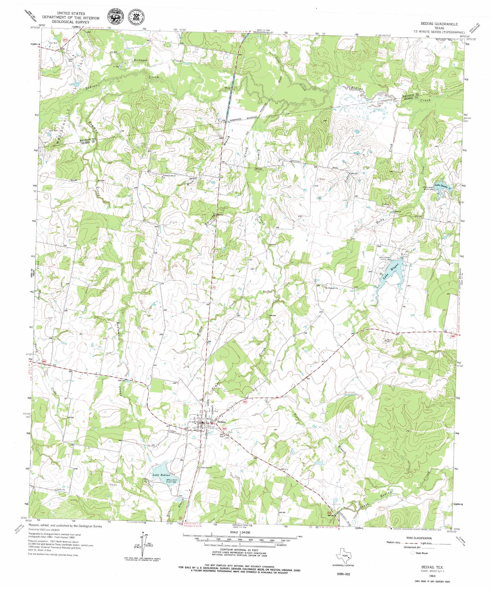
Bedias Topo Map Texas
To zoom in, hover over the map of Bedias
USGS Topo Quad 30095g8 - 1:24,000 scale
| Topo Map Name: | Bedias |
| USGS Topo Quad ID: | 30095g8 |
| Print Size: | ca. 21 1/4" wide x 27" high |
| Southeast Coordinates: | 30.75° N latitude / 95.875° W longitude |
| Map Center Coordinates: | 30.8125° N latitude / 95.9375° W longitude |
| U.S. State: | TX |
| Filename: | o30095g8.jpg |
| Download Map JPG Image: | Bedias topo map 1:24,000 scale |
| Map Type: | Topographic |
| Topo Series: | 7.5´ |
| Map Scale: | 1:24,000 |
| Source of Map Images: | United States Geological Survey (USGS) |
| Alternate Map Versions: |
Bedias TX 1963, updated 1964 Download PDF Buy paper map Bedias TX 2010 Download PDF Buy paper map Bedias TX 2013 Download PDF Buy paper map Bedias TX 2016 Download PDF Buy paper map |
1:24,000 Topo Quads surrounding Bedias
Hilltop Lakes |
Normangee |
Leona Sw |
Elwood |
Sand Ridge |
Canary |
North Zulch |
Madisonville |
Connor |
Baker Lake |
Clear Lake |
Iola |
Bedias |
Steep Branch |
Crabbs Prairie |
Reliance |
Keith |
Singleton |
Loma |
Galilee |
Ferguson Crossing |
Carlos |
Roans Prairie |
Richards |
San Jacinto |
> Back to 30095e1 at 1:100,000 scale
> Back to 30094a1 at 1:250,000 scale
> Back to U.S. Topo Maps home
Bedias topo map: Gazetteer
Bedias: Dams
Bullard Lake Dam elevation 66m 216′Lake Bedias Dam elevation 102m 334′
Lake Donna V Dam elevation 69m 226′
Lake Wayne Dam elevation 79m 259′
Bedias: Populated Places
Bedias elevation 103m 337′Cotton elevation 71m 232′
Bedias: Reservoirs
Bullard Lake elevation 66m 216′Lake Bedias elevation 100m 328′
Lake Donna V elevation 72m 236′
Lake Wayne elevation 78m 255′
Bedias: Streams
Bedias Creek elevation 58m 190′Bishop Creek elevation 76m 249′
Bowman Creek elevation 66m 216′
Cedar Creek elevation 59m 193′
Iron Creek elevation 62m 203′
Kickapoo Creek elevation 66m 216′
Rocky Creek elevation 59m 193′
Simes Creek elevation 64m 209′
Town Branch elevation 75m 246′
Twisted Creek elevation 65m 213′
Wren Branch elevation 64m 209′
Bedias digital topo map on disk
Buy this Bedias topo map showing relief, roads, GPS coordinates and other geographical features, as a high-resolution digital map file on DVD: