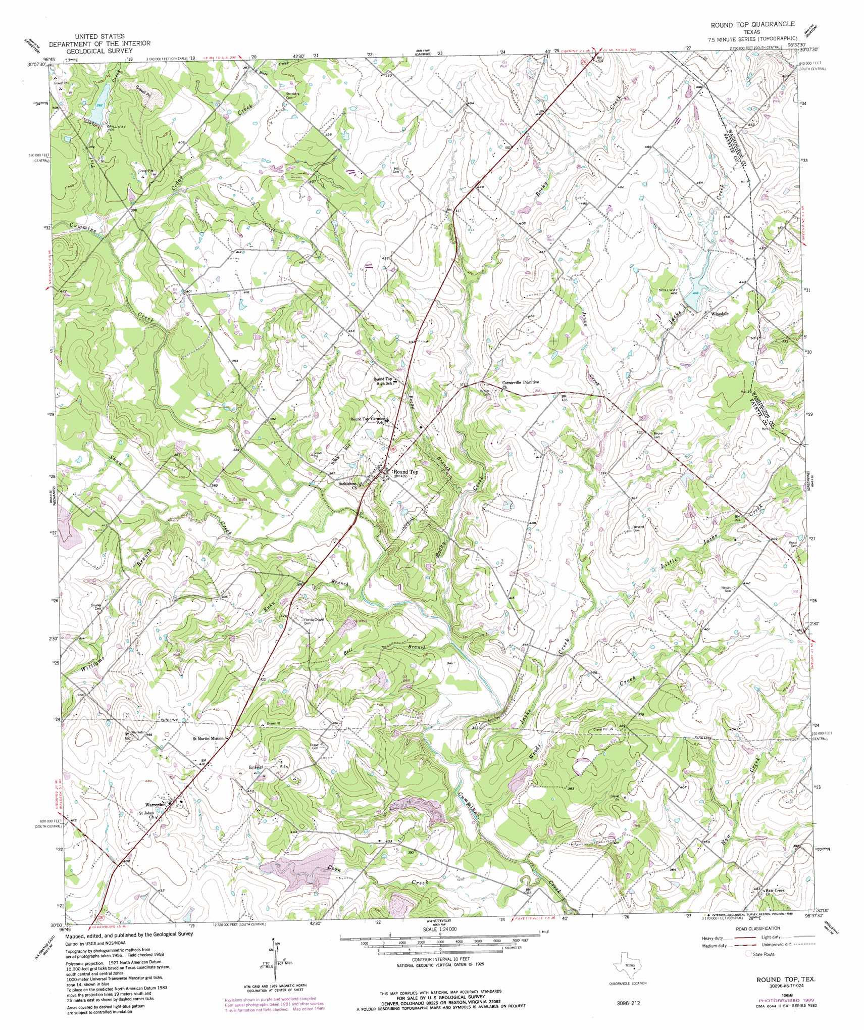
Round Top Topo Map Texas
To zoom in, hover over the map of Round Top
USGS Topo Quad 30096a6 - 1:24,000 scale
| Topo Map Name: | Round Top |
| USGS Topo Quad ID: | 30096a6 |
| Print Size: | ca. 21 1/4" wide x 27" high |
| Southeast Coordinates: | 30° N latitude / 96.625° W longitude |
| Map Center Coordinates: | 30.0625° N latitude / 96.6875° W longitude |
| U.S. State: | TX |
| Filename: | o30096a6.jpg |
| Download Map JPG Image: | Round Top topo map 1:24,000 scale |
| Map Type: | Topographic |
| Topo Series: | 7.5´ |
| Map Scale: | 1:24,000 |
| Source of Map Images: | United States Geological Survey (USGS) |
| Alternate Map Versions: |
Round Top TX 1958, updated 1959 Download PDF Buy paper map Round Top TX 1958, updated 1989 Download PDF Buy paper map Round Top TX 2010 Download PDF Buy paper map Round Top TX 2013 Download PDF Buy paper map Round Top TX 2016 Download PDF Buy paper map |
1:24,000 Topo Quads surrounding Round Top
Lincoln |
Dime Box |
Flag Pond |
Somerville |
Gay Hill |
Giddings |
Ledbetter |
Carmine |
Burton |
Brenham |
Warda |
Nechanitz |
Round Top |
Greenvine |
Welcome |
La Grange West |
La Grange East |
Fayetteville |
Industry |
New Ulm |
Swiss Alp |
Ammannsville |
Ellinger |
Frelsburg |
Bernardo |
> Back to 30096a1 at 1:100,000 scale
> Back to 30096a1 at 1:250,000 scale
> Back to U.S. Topo Maps home
Round Top topo map: Gazetteer
Round Top: Airports
El Paisano Airport elevation 102m 334′Round Top: Bridges
Cummins Creek Bridge elevation 104m 341′Round Top: Dams
Dam Number 15 elevation 130m 426′Knutzen Lake Dam elevation 98m 321′
Soil Conservation Service Site 11 Dam elevation 119m 390′
Soil Conservation Service Site 15 Dam elevation 127m 416′
Soil Conservation Service Site 17 Dam elevation 103m 337′
Soil Conservation Service Site 19 Dam elevation 112m 367′
Soil Conservation Service Site 6 Dam elevation 121m 396′
Round Top: Populated Places
Haw Creek (historical) elevation 123m 403′Round Top elevation 134m 439′
Warrenton elevation 142m 465′
Winedale elevation 135m 442′
Round Top: Reservoirs
Knutzen Lake elevation 98m 321′Soil Conservation Service Site 11 Reservoir elevation 119m 390′
Soil Conservation Service Site 15 Reservoir elevation 127m 416′
Soil Conservation Service Site 17 Reservoir elevation 103m 337′
Soil Conservation Service Site 19 Reservoir elevation 112m 367′
Soil Conservation Service Site 6 Reservoir elevation 121m 396′
Round Top: Streams
Bell Branch elevation 97m 318′Boggy Branch elevation 103m 337′
Buck Creek elevation 116m 380′
Cedar Creek elevation 109m 357′
Coon Creek elevation 91m 298′
Flat Creek elevation 109m 357′
Jacks Creek elevation 93m 305′
Jenny Creek elevation 111m 364′
Kuhn Branch elevation 99m 324′
Little Jacks Creek elevation 104m 341′
Rocky Creek elevation 98m 321′
Shaw Creek elevation 101m 331′
West Rocky Creek elevation 117m 383′
Williams Branch elevation 108m 354′
Woods Creek elevation 91m 298′
Round Top digital topo map on disk
Buy this Round Top topo map showing relief, roads, GPS coordinates and other geographical features, as a high-resolution digital map file on DVD: