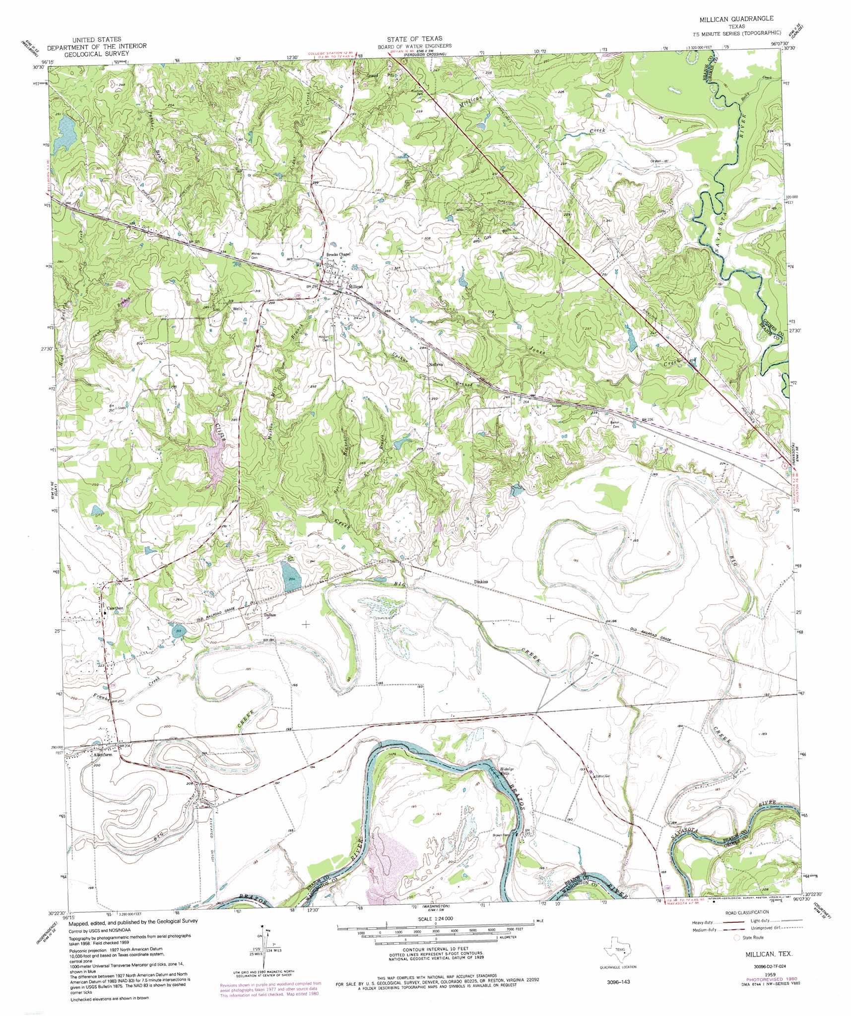
Millican Topo Map Texas
To zoom in, hover over the map of Millican
USGS Topo Quad 30096d2 - 1:24,000 scale
| Topo Map Name: | Millican |
| USGS Topo Quad ID: | 30096d2 |
| Print Size: | ca. 21 1/4" wide x 27" high |
| Southeast Coordinates: | 30.375° N latitude / 96.125° W longitude |
| Map Center Coordinates: | 30.4375° N latitude / 96.1875° W longitude |
| U.S. State: | TX |
| Filename: | o30096d2.jpg |
| Download Map JPG Image: | Millican topo map 1:24,000 scale |
| Map Type: | Topographic |
| Topo Series: | 7.5´ |
| Map Scale: | 1:24,000 |
| Source of Map Images: | United States Geological Survey (USGS) |
| Alternate Map Versions: |
Millican TX 1959, updated 1960 Download PDF Buy paper map Millican TX 1959, updated 1970 Download PDF Buy paper map Millican TX 1959, updated 1980 Download PDF Buy paper map Millican TX 1959, updated 1991 Download PDF Buy paper map Millican TX 2010 Download PDF Buy paper map Millican TX 2013 Download PDF Buy paper map Millican TX 2016 Download PDF Buy paper map |
1:24,000 Topo Quads surrounding Millican
Bryan West |
Bryan East |
Reliance |
Keith |
Singleton |
Chances Store |
Wellborn |
Ferguson Crossing |
Carlos |
Roans Prairie |
Snook |
Clay |
Millican |
Navasota |
Anderson |
Gay Hill |
Independence |
Washington |
Courtney |
Stoneham |
Brenham |
Chappell Hill |
Daniels |
Howth |
Waller Nw |
> Back to 30096a1 at 1:100,000 scale
> Back to 30096a1 at 1:250,000 scale
> Back to U.S. Topo Maps home
Millican topo map: Gazetteer
Millican: Airports
Tom J Moore Farm Airport elevation 60m 196′Millican: Dams
Cawthorn Lake Dam elevation 66m 216′Clifty Creek Lake Dam elevation 72m 236′
Prescott Dam elevation 76m 249′
Rotello Lake Dam elevation 64m 209′
Soil Conservation Service Site 5 Dam elevation 66m 216′
Soil Conservation Service Site 6 Dam elevation 60m 196′
Millican: Falls
Hidalgo Falls elevation 48m 157′Millican: Populated Places
Allenfarm elevation 61m 200′Cawthon elevation 71m 232′
Dallam elevation 64m 209′
Dinkins elevation 59m 193′
Millican elevation 95m 311′
Nelleva elevation 82m 269′
Millican: Reservoirs
Cawthorn Lake elevation 66m 216′Clifty Creek Lake elevation 72m 236′
Prescott Lake elevation 76m 249′
Rotello Lake elevation 64m 209′
Soil Conservation Service Site 5 Reservoir elevation 66m 216′
Soil Conservation Service Site 6 Reservoir elevation 60m 196′
Millican: Streams
Big Creek elevation 48m 157′Clifty Creek elevation 58m 190′
Franks Creek elevation 56m 183′
Hutton Mill Branch elevation 67m 219′
Jones Creek elevation 53m 173′
Knox Branch elevation 61m 200′
Millican Creek elevation 53m 173′
Rocky Creek elevation 53m 173′
Sand Branch elevation 70m 229′
Spring Branch elevation 60m 196′
Upshur Branch elevation 66m 216′
Millican digital topo map on disk
Buy this Millican topo map showing relief, roads, GPS coordinates and other geographical features, as a high-resolution digital map file on DVD: