Clay Topo Map Texas
To zoom in, hover over the map of Clay
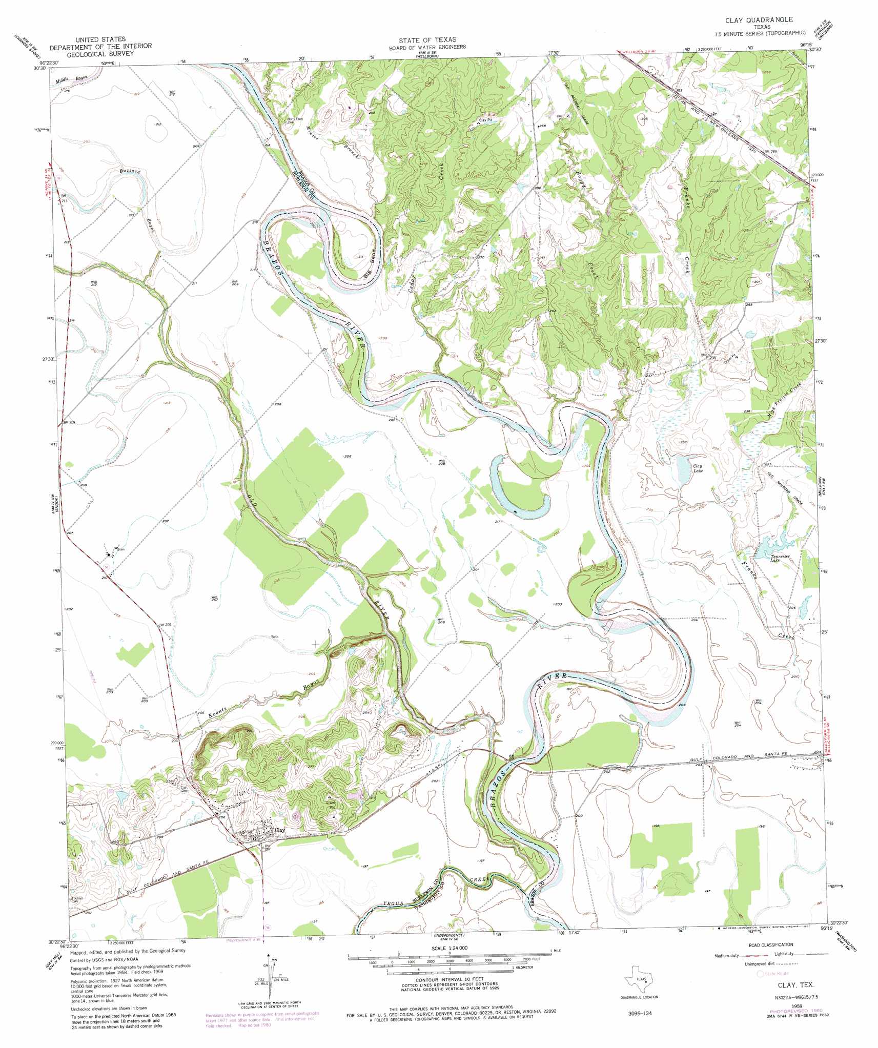
USGS Topo Quad 30096d3 - 1:24,000 scale
| Topo Map Name: | Clay |
| USGS Topo Quad ID: | 30096d3 |
| Print Size: | ca. 21 1/4" wide x 27" high |
| Southeast Coordinates: | 30.375° N latitude / 96.25° W longitude |
| Map Center Coordinates: | 30.4375° N latitude / 96.3125° W longitude |
| U.S. State: | TX |
| Filename: | o30096d3.jpg |
| Download Map JPG Image: | Clay topo map 1:24,000 scale |
| Map Type: | Topographic |
| Topo Series: | 7.5´ |
| Map Scale: | 1:24,000 |
| Source of Map Images: | United States Geological Survey (USGS) |
| Alternate Map Versions: |
Clay TX 1959, updated 1960 Download PDF Buy paper map Clay TX 1959, updated 1972 Download PDF Buy paper map Clay TX 1959, updated 1980 Download PDF Buy paper map Clay TX 2010 Download PDF Buy paper map Clay TX 2013 Download PDF Buy paper map Clay TX 2016 Download PDF Buy paper map |
1:24,000 Topo Quads surrounding Clay
Mumford |
Bryan West |
Bryan East |
Reliance |
Keith |
Tunis |
Chances Store |
Wellborn |
Ferguson Crossing |
Carlos |
Lyons |
Snook |
Clay |
Millican |
Navasota |
Somerville |
Gay Hill |
Independence |
Washington |
Courtney |
Burton |
Brenham |
Chappell Hill |
Daniels |
Howth |
> Back to 30096a1 at 1:100,000 scale
> Back to 30096a1 at 1:250,000 scale
> Back to U.S. Topo Maps home
Clay topo map: Gazetteer
Clay: Dams
Tennessee Lake Dam elevation 66m 216′Wilkins Lake Dam elevation 61m 200′
Clay: Guts
Buzzard Bayou elevation 63m 206′Clay: Lakes
Clay Lake elevation 61m 200′Clay: Populated Places
Clay elevation 68m 223′Clay: Reservoirs
Tennessee Lake elevation 66m 216′Wilkins Lake elevation 61m 200′
Clay: Streams
Boggy Creek elevation 55m 180′Cedar Creek elevation 54m 177′
High Prairie Creek elevation 61m 200′
Koontz Bayou elevation 54m 177′
Minter Branch elevation 58m 190′
Old River elevation 54m 177′
Yegua Creek elevation 51m 167′
Clay digital topo map on disk
Buy this Clay topo map showing relief, roads, GPS coordinates and other geographical features, as a high-resolution digital map file on DVD: