Chances Store Topo Map Texas
To zoom in, hover over the map of Chances Store
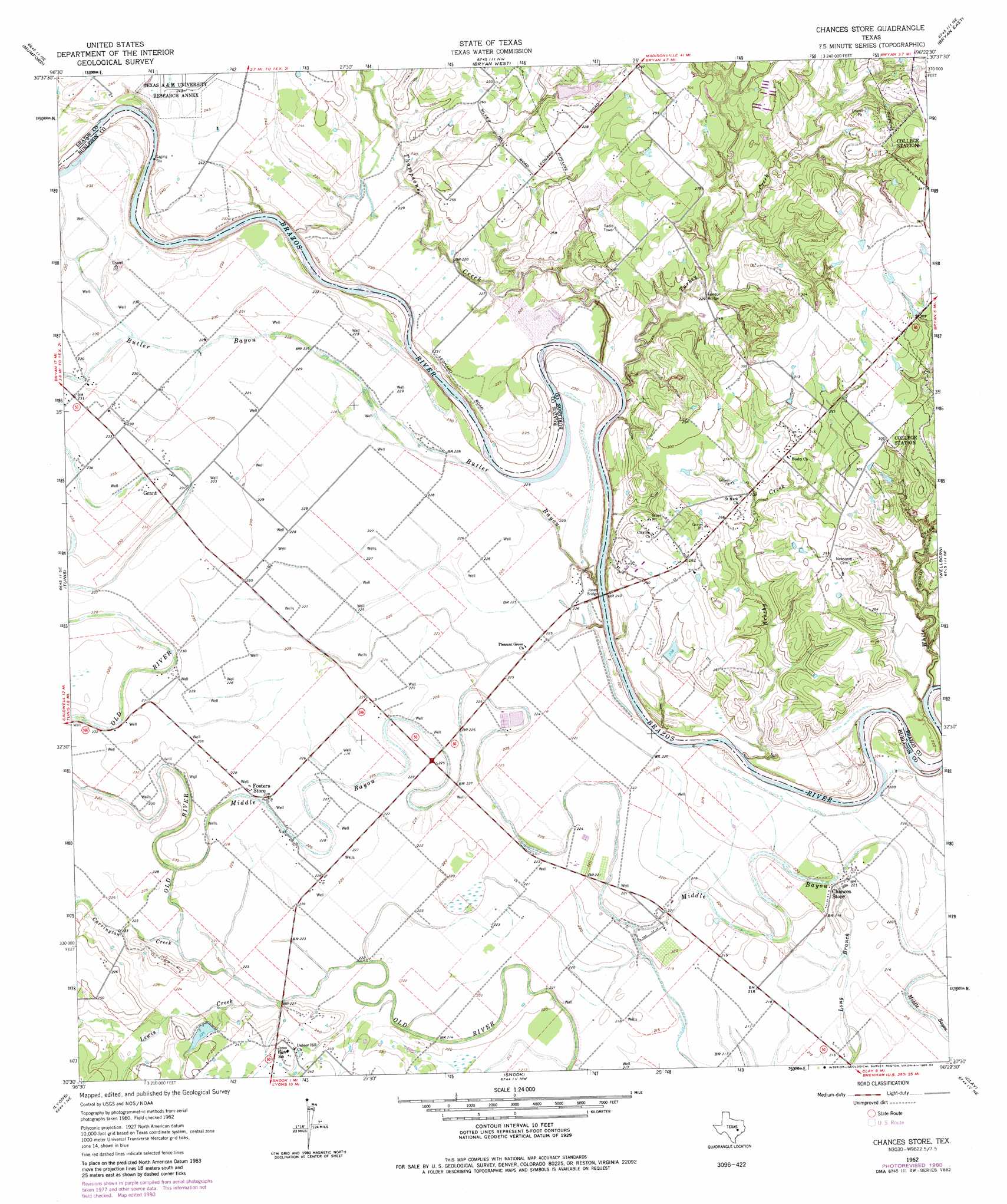
USGS Topo Quad 30096e4 - 1:24,000 scale
| Topo Map Name: | Chances Store |
| USGS Topo Quad ID: | 30096e4 |
| Print Size: | ca. 21 1/4" wide x 27" high |
| Southeast Coordinates: | 30.5° N latitude / 96.375° W longitude |
| Map Center Coordinates: | 30.5625° N latitude / 96.4375° W longitude |
| U.S. State: | TX |
| Filename: | o30096e4.jpg |
| Download Map JPG Image: | Chances Store topo map 1:24,000 scale |
| Map Type: | Topographic |
| Topo Series: | 7.5´ |
| Map Scale: | 1:24,000 |
| Source of Map Images: | United States Geological Survey (USGS) |
| Alternate Map Versions: |
Chances Store TX 1962, updated 1964 Download PDF Buy paper map Chances Store TX 1962, updated 1972 Download PDF Buy paper map Chances Store TX 1962, updated 1973 Download PDF Buy paper map Chances Store TX 1962, updated 1980 Download PDF Buy paper map Chances Store TX 1962, updated 1984 Download PDF Buy paper map Chances Store TX 2010 Download PDF Buy paper map Chances Store TX 2013 Download PDF Buy paper map Chances Store TX 2016 Download PDF Buy paper map |
1:24,000 Topo Quads surrounding Chances Store
Gause |
Hearne South |
Dunn Creek |
Kurten |
Clear Lake |
Goodwill |
Mumford |
Bryan West |
Bryan East |
Reliance |
Caldwell |
Tunis |
Chances Store |
Wellborn |
Ferguson Crossing |
Frenstat |
Lyons |
Snook |
Clay |
Millican |
Flag Pond |
Somerville |
Gay Hill |
Independence |
Washington |
> Back to 30096e1 at 1:100,000 scale
> Back to 30096a1 at 1:250,000 scale
> Back to U.S. Topo Maps home
Chances Store topo map: Gazetteer
Chances Store: Bridges
Jones Bridge elevation 57m 187′London Bridge elevation 68m 223′
Chances Store: Dams
Giesensclag Lake Dam elevation 71m 232′Linda Lake Dam elevation 79m 259′
Chances Store: Guts
Butler Bayou elevation 69m 226′Middle Bayou elevation 64m 209′
Chances Store: Parks
Steele-Milburn Field elevation 82m 269′Chances Store: Populated Places
Chances Store elevation 67m 219′Chances Store: Reservoirs
Giesensclag Lake elevation 71m 232′Linda Lake elevation 79m 259′
Chances Store: Streams
Brushy Creek elevation 62m 203′Carrington Creek elevation 65m 213′
Lewis Creek elevation 67m 219′
Thompsons Creek elevation 64m 209′
Turkey Creek elevation 60m 196′
White Creek elevation 56m 183′
Chances Store digital topo map on disk
Buy this Chances Store topo map showing relief, roads, GPS coordinates and other geographical features, as a high-resolution digital map file on DVD: