Dunn Creek Topo Map Texas
To zoom in, hover over the map of Dunn Creek
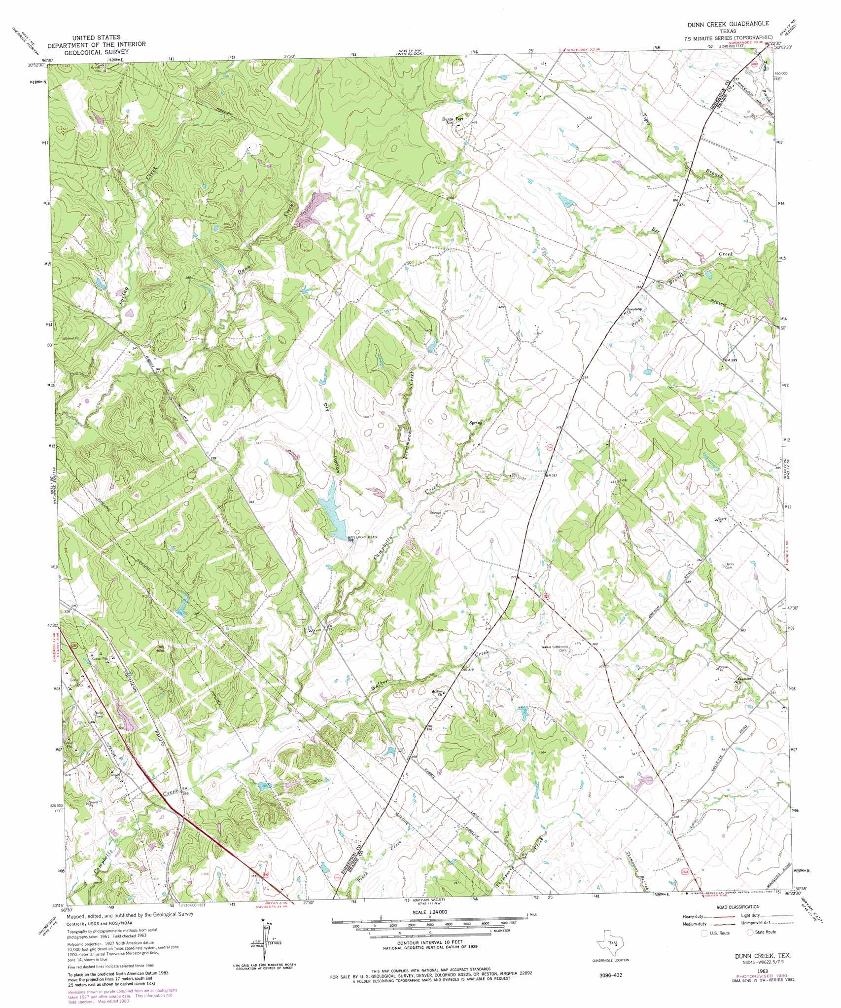
USGS Topo Quad 30096g4 - 1:24,000 scale
| Topo Map Name: | Dunn Creek |
| USGS Topo Quad ID: | 30096g4 |
| Print Size: | ca. 21 1/4" wide x 27" high |
| Southeast Coordinates: | 30.75° N latitude / 96.375° W longitude |
| Map Center Coordinates: | 30.8125° N latitude / 96.4375° W longitude |
| U.S. State: | TX |
| Filename: | o30096g4.jpg |
| Download Map JPG Image: | Dunn Creek topo map 1:24,000 scale |
| Map Type: | Topographic |
| Topo Series: | 7.5´ |
| Map Scale: | 1:24,000 |
| Source of Map Images: | United States Geological Survey (USGS) |
| Alternate Map Versions: |
Dunn Creek TX 1963, updated 1964 Download PDF Buy paper map Dunn Creek TX 1963, updated 1980 Download PDF Buy paper map Dunn Creek TX 2010 Download PDF Buy paper map Dunn Creek TX 2013 Download PDF Buy paper map Dunn Creek TX 2016 Download PDF Buy paper map |
1:24,000 Topo Quads surrounding Dunn Creek
Hammond |
Owensville |
Franklin |
Camp Creek Lake |
Hilltop Lakes |
Calvert |
Hearne North |
Wheelock |
Edge |
Canary |
Gause |
Hearne South |
Dunn Creek |
Kurten |
Clear Lake |
Goodwill |
Mumford |
Bryan West |
Bryan East |
Reliance |
Caldwell |
Tunis |
Chances Store |
Wellborn |
Ferguson Crossing |
> Back to 30096e1 at 1:100,000 scale
> Back to 30096a1 at 1:250,000 scale
> Back to U.S. Topo Maps home
Dunn Creek topo map: Gazetteer
Dunn Creek: Dams
P and M Bank Club Lake Dam elevation 107m 351′Peters Lake Dam elevation 113m 370′
Pryor Lake Dam elevation 122m 400′
Savoy-Gant Lake Dam elevation 89m 291′
Seale Lake Dam elevation 96m 314′
Dunn Creek: Populated Places
Dunns Fort elevation 140m 459′Dunn Creek: Reservoirs
P and M Bank Club Lake elevation 107m 351′Peters Lake elevation 113m 370′
Pryor Lake elevation 122m 400′
Savoy-Gant Lake elevation 89m 291′
Seale Lake elevation 96m 314′
Dunn Creek: Streams
Pecan Branch elevation 104m 341′Persimmon Creek elevation 98m 321′
Walker Creek elevation 84m 275′
Dunn Creek: Valleys
Dry Hollow elevation 92m 301′Dunn Creek digital topo map on disk
Buy this Dunn Creek topo map showing relief, roads, GPS coordinates and other geographical features, as a high-resolution digital map file on DVD: