Smithville Topo Map Texas
To zoom in, hover over the map of Smithville
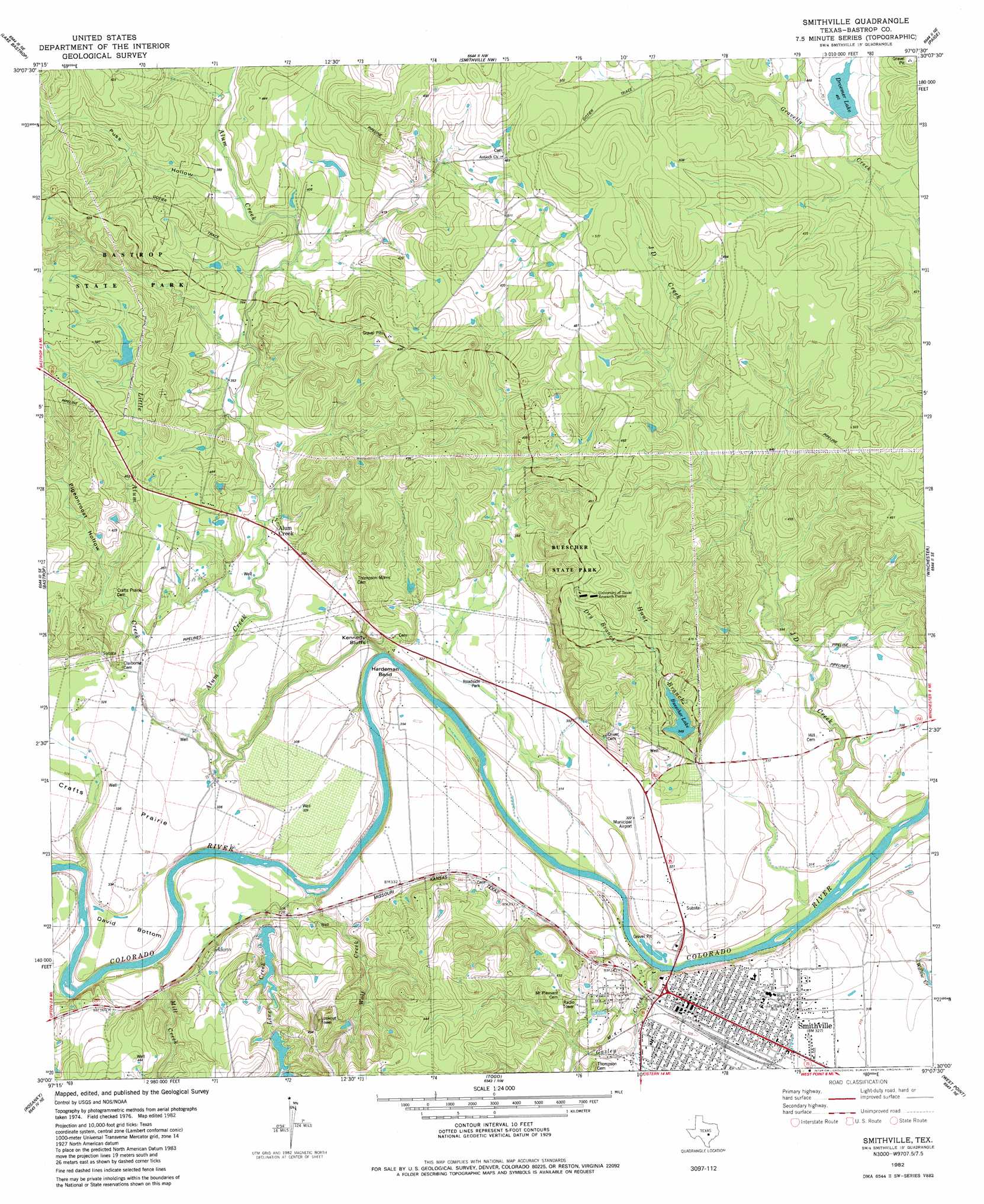
USGS Topo Quad 30097a2 - 1:24,000 scale
| Topo Map Name: | Smithville |
| USGS Topo Quad ID: | 30097a2 |
| Print Size: | ca. 21 1/4" wide x 27" high |
| Southeast Coordinates: | 30° N latitude / 97.125° W longitude |
| Map Center Coordinates: | 30.0625° N latitude / 97.1875° W longitude |
| U.S. State: | TX |
| Filename: | o30097a2.jpg |
| Download Map JPG Image: | Smithville topo map 1:24,000 scale |
| Map Type: | Topographic |
| Topo Series: | 7.5´ |
| Map Scale: | 1:24,000 |
| Source of Map Images: | United States Geological Survey (USGS) |
| Alternate Map Versions: |
Smithville TX 1982, updated 1982 Download PDF Buy paper map Smithville TX 1982, updated 1982 Download PDF Buy paper map Smithville TX 2010 Download PDF Buy paper map Smithville TX 2013 Download PDF Buy paper map Smithville TX 2016 Download PDF Buy paper map |
1:24,000 Topo Quads surrounding Smithville
Elgin West |
Elgin East |
Mcdade |
Fedor |
Lincoln |
Utley |
Lake Bastrop |
Smithville Nw |
Paige |
Giddings |
Bastrop Sw |
Bastrap |
Smithville |
Winchester |
Warda |
Red Rock |
Rosanky |
Togo |
West Point |
La Grange West |
Delhi |
Jeddo |
Cistern |
Muldoon |
Swiss Alp |
> Back to 30097a1 at 1:100,000 scale
> Back to 30096a1 at 1:250,000 scale
> Back to U.S. Topo Maps home
Smithville topo map: Gazetteer
Smithville: Airports
Smithville Municipal Airport elevation 98m 321′Smithville: Bends
Hardeman Bend elevation 91m 298′Smithville: Cliffs
Kennedy Bluffs elevation 100m 328′Smithville: Dams
A J Rod Dam elevation 109m 357′Buescher State Park Lake Dam elevation 106m 347′
Droemer Dam elevation 133m 436′
Harmon Dam elevation 144m 472′
Rod Lake Number 1 Dam elevation 119m 390′
Rod Lake Number 2 Dam elevation 120m 393′
Smithville: Lakes
Dancing Turtles Lake elevation 122m 400′Smithville: Parks
Buescher State Park elevation 146m 479′Smithville: Populated Places
Alum Creek elevation 106m 347′Smithville elevation 99m 324′
Smithville: Reservoirs
A J Rod Lake elevation 109m 357′Buescher Lake elevation 105m 344′
Buescher State Park Lake elevation 106m 347′
Droemer Lake elevation 133m 436′
Harmon Lake elevation 144m 472′
Rod Lake Number 1 elevation 119m 390′
Rod Lake Number 2 elevation 120m 393′
Smithville: Streams
Alum Creek elevation 85m 278′East Fork Gravelly Creek elevation 131m 429′
Gazley Creek elevation 85m 278′
Hunt Branch elevation 84m 275′
J D Creek elevation 83m 272′
Line Creek elevation 91m 298′
Little Alum Creek elevation 90m 295′
Mill Creek elevation 90m 295′
Reeds Creek elevation 88m 288′
West Fork Gravelly Creek elevation 131m 429′
Wolf Creek elevation 85m 278′
Smithville: Trails
Buescher State Park Hiking Trail elevation 116m 380′Smithville: Valleys
Pigeonroost Hollow elevation 109m 357′Smithville digital topo map on disk
Buy this Smithville topo map showing relief, roads, GPS coordinates and other geographical features, as a high-resolution digital map file on DVD: