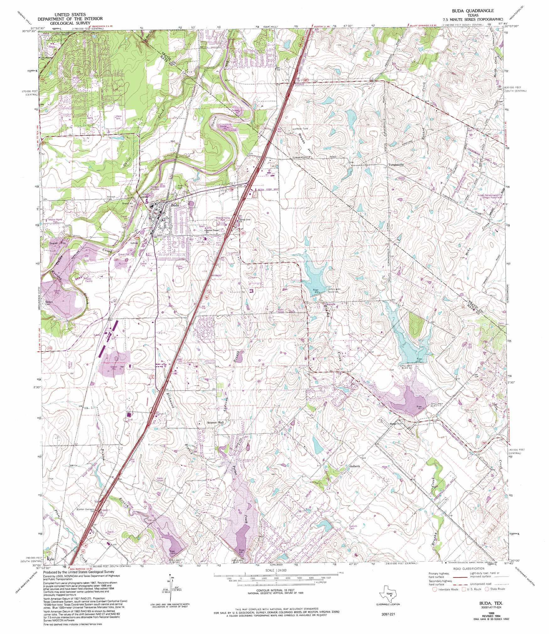
Buda Topo Map Texas
To zoom in, hover over the map of Buda
USGS Topo Quad 30097a7 - 1:24,000 scale
| Topo Map Name: | Buda |
| USGS Topo Quad ID: | 30097a7 |
| Print Size: | ca. 21 1/4" wide x 27" high |
| Southeast Coordinates: | 30° N latitude / 97.75° W longitude |
| Map Center Coordinates: | 30.0625° N latitude / 97.8125° W longitude |
| U.S. State: | TX |
| Filename: | o30097a7.jpg |
| Download Map JPG Image: | Buda topo map 1:24,000 scale |
| Map Type: | Topographic |
| Topo Series: | 7.5´ |
| Map Scale: | 1:24,000 |
| Source of Map Images: | United States Geological Survey (USGS) |
| Alternate Map Versions: |
Buda TX 1968, updated 1971 Download PDF Buy paper map Buda TX 1968, updated 1975 Download PDF Buy paper map Buda TX 1968, updated 1984 Download PDF Buy paper map Buda TX 1968, updated 1994 Download PDF Buy paper map Buda TX 2010 Download PDF Buy paper map Buda TX 2013 Download PDF Buy paper map Buda TX 2016 Download PDF Buy paper map |
1:24,000 Topo Quads surrounding Buda
Shingle Hills |
Bee Cave |
Austin West |
Austin East |
Manor |
Dripping Springs |
Signal Hill |
Oak Hill |
Montopolis |
Webberville |
Driftwood |
Mountain City |
Buda |
Creedmoor |
Lytton Springs |
Wimberley |
San Marcos North |
Uhland |
Lockhart North |
Dale |
Hunter |
San Marcos South |
Martindale |
Lockhart South |
Mcmahan |
> Back to 30097a1 at 1:100,000 scale
> Back to 30096a1 at 1:250,000 scale
> Back to U.S. Topo Maps home
Buda topo map: Gazetteer
Buda: Crossings
Interchange 217 elevation 213m 698′Buda: Dams
Barron Lake Dam elevation 190m 623′Heep Lake Dam elevation 203m 666′
Jan Land Company Lake Number 1 Dam elevation 183m 600′
Soil Conservation Service Site 10 Dam elevation 205m 672′
Soil Conservation Service Site 11 Dam elevation 192m 629′
Soil Conservation Service Site 12 Dam elevation 182m 597′
Soil Conservation Service Site 5 Dam elevation 193m 633′
Soil Conservation Service Site 6 Dam elevation 191m 626′
Texas No Name Number 10 Dam elevation 217m 711′
Texas No Name Number 9 Dam elevation 213m 698′
Buda: Populated Places
Buda elevation 214m 702′Goforth elevation 189m 620′
Hays elevation 222m 728′
Turnersville elevation 222m 728′
Buda: Reservoirs
Barron Lake elevation 190m 623′Heep Lake elevation 213m 698′
Lake Number 1 elevation 183m 600′
Soil Conservation Service Site 10 Reservoir elevation 205m 672′
Soil Conservation Service Site 12 Reservoir elevation 182m 597′
Soil Conservation Service Site 5 Reservoir elevation 193m 633′
Soil Conservation Service Site 6 Reservoir elevation 191m 626′
Buda: Springs
Manchaca Springs elevation 206m 675′Buda: Streams
Andrews Branch elevation 195m 639′Garlic Creek elevation 189m 620′
Mustang Branch elevation 214m 702′
Richmond Branch elevation 195m 639′
Buda: Summits
Woods Hill elevation 230m 754′Buda digital topo map on disk
Buy this Buda topo map showing relief, roads, GPS coordinates and other geographical features, as a high-resolution digital map file on DVD: