Lake Bastrop Topo Map Texas
To zoom in, hover over the map of Lake Bastrop
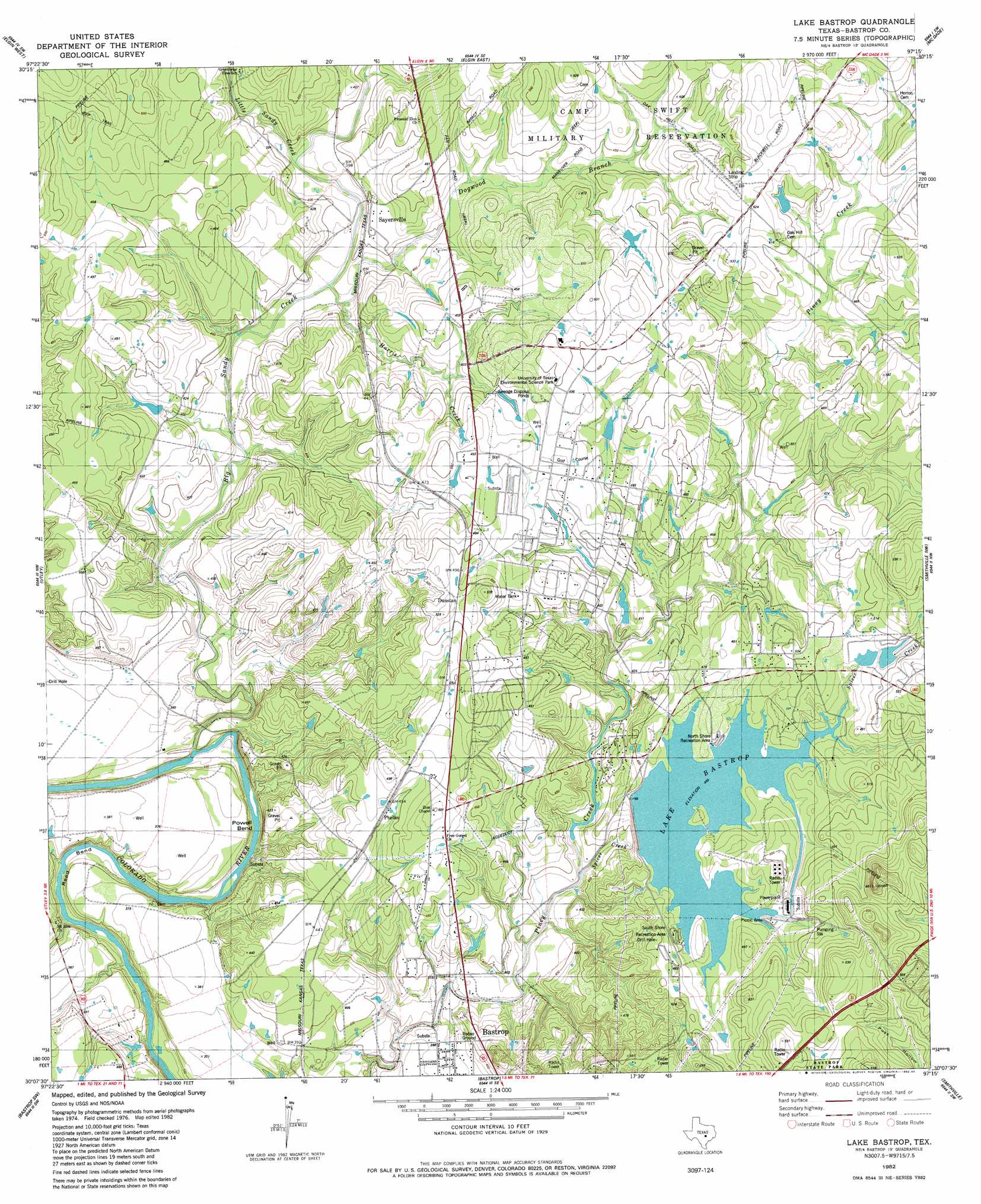
USGS Topo Quad 30097b3 - 1:24,000 scale
| Topo Map Name: | Lake Bastrop |
| USGS Topo Quad ID: | 30097b3 |
| Print Size: | ca. 21 1/4" wide x 27" high |
| Southeast Coordinates: | 30.125° N latitude / 97.25° W longitude |
| Map Center Coordinates: | 30.1875° N latitude / 97.3125° W longitude |
| U.S. State: | TX |
| Filename: | o30097b3.jpg |
| Download Map JPG Image: | Lake Bastrop topo map 1:24,000 scale |
| Map Type: | Topographic |
| Topo Series: | 7.5´ |
| Map Scale: | 1:24,000 |
| Source of Map Images: | United States Geological Survey (USGS) |
| Alternate Map Versions: |
Lake Bastrop TX 1982, updated 1982 Download PDF Buy paper map Lake Bastrop TX 1982, updated 1985 Download PDF Buy paper map Lake Bastrop TX 2010 Download PDF Buy paper map Lake Bastrop TX 2013 Download PDF Buy paper map Lake Bastrop TX 2016 Download PDF Buy paper map |
1:24,000 Topo Quads surrounding Lake Bastrop
Pflugerville East |
Coupland |
Structure |
Beaukiss |
Lexington |
Manor |
Elgin West |
Elgin East |
Mcdade |
Fedor |
Webberville |
Utley |
Lake Bastrop |
Smithville Nw |
Paige |
Lytton Springs |
Bastrop Sw |
Bastrap |
Smithville |
Winchester |
Dale |
Red Rock |
Rosanky |
Togo |
West Point |
> Back to 30097a1 at 1:100,000 scale
> Back to 30096a1 at 1:250,000 scale
> Back to U.S. Topo Maps home
Lake Bastrop topo map: Gazetteer
Lake Bastrop: Bends
Powell Bend elevation 113m 370′Reed Bend elevation 110m 360′
Lake Bastrop: Dams
Hicks Lake Dam elevation 147m 482′Lake Bastrop Dam elevation 134m 439′
Sanders Dam elevation 129m 423′
Tuck Lake Dam elevation 122m 400′
Lake Bastrop: Parks
Lake Bastrop - North Shores Park elevation 143m 469′Lake Bastrop - South Shores Park elevation 141m 462′
Lake Bastrop: Populated Places
Camp Swift elevation 134m 439′Phelan elevation 137m 449′
Pine Hills elevation 167m 547′
Sayersville elevation 126m 413′
Swiftex elevation 150m 492′
Lake Bastrop: Reservoirs
Hicks Lake elevation 147m 482′Lake Bastrop elevation 134m 439′
Sanders Lake elevation 129m 423′
Tuck Lake elevation 122m 400′
Lake Bastrop: Streams
Big Sandy Creek elevation 101m 331′Little Sandy Creek elevation 116m 380′
Spicer Creek elevation 116m 380′
Lake Bastrop digital topo map on disk
Buy this Lake Bastrop topo map showing relief, roads, GPS coordinates and other geographical features, as a high-resolution digital map file on DVD: