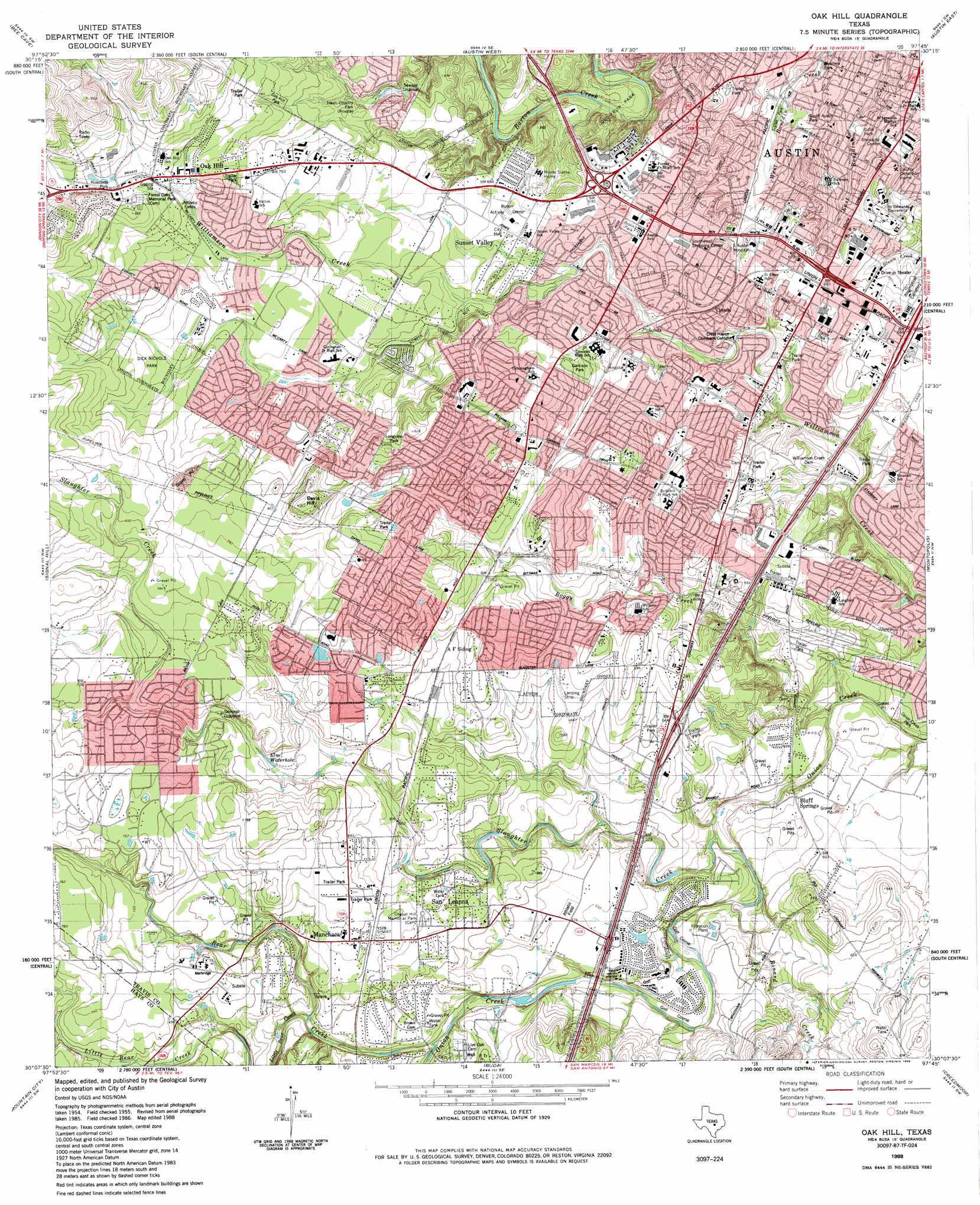
Oak Hill Topo Map Texas
To zoom in, hover over the map of Oak Hill
USGS Topo Quad 30097b7 - 1:24,000 scale
| Topo Map Name: | Oak Hill |
| USGS Topo Quad ID: | 30097b7 |
| Print Size: | ca. 21 1/4" wide x 27" high |
| Southeast Coordinates: | 30.125° N latitude / 97.75° W longitude |
| Map Center Coordinates: | 30.1875° N latitude / 97.8125° W longitude |
| U.S. State: | TX |
| Filename: | o30097b7.jpg |
| Download Map JPG Image: | Oak Hill topo map 1:24,000 scale |
| Map Type: | Topographic |
| Topo Series: | 7.5´ |
| Map Scale: | 1:24,000 |
| Source of Map Images: | United States Geological Survey (USGS) |
| Alternate Map Versions: |
Oak Hill TX 1955, updated 1956 Download PDF Buy paper map Oak Hill TX 1966, updated 1969 Download PDF Buy paper map Oak Hill TX 1966, updated 1986 Download PDF Buy paper map Oak Hill TX 1988, updated 1988 Download PDF Buy paper map Oak Hill TX 2010 Download PDF Buy paper map Oak Hill TX 2013 Download PDF Buy paper map Oak Hill TX 2016 Download PDF Buy paper map |
1:24,000 Topo Quads surrounding Oak Hill
Pace Bend |
Mansfield Dam |
Jollyville |
Pflugerville West |
Pflugerville East |
Shingle Hills |
Bee Cave |
Austin West |
Austin East |
Manor |
Dripping Springs |
Signal Hill |
Oak Hill |
Montopolis |
Webberville |
Driftwood |
Mountain City |
Buda |
Creedmoor |
Lytton Springs |
Wimberley |
San Marcos North |
Uhland |
Lockhart North |
Dale |
> Back to 30097a1 at 1:100,000 scale
> Back to 30096a1 at 1:250,000 scale
> Back to U.S. Topo Maps home
Oak Hill topo map: Gazetteer
Oak Hill: Crossings
Interchange 225A elevation 192m 629′Interchange 225C elevation 187m 613′
Interchange 226 elevation 197m 646′
Interchange 227 elevation 195m 639′
Interchange 228 elevation 199m 652′
Interchange 229 elevation 191m 626′
Interchange 230B elevation 203m 666′
Oak Hill: Lakes
Elm Waterhole elevation 211m 692′Oak Hill: Parks
Battle Bend Park elevation 190m 623′Burger Stadium - Austin Independent School District elevation 207m 679′
Chapel Hill Park elevation 211m 692′
Dick Nichols Park elevation 237m 777′
Dittmar Park elevation 208m 682′
Garrison Park elevation 211m 692′
Gillis Park elevation 168m 551′
Gus Fruh Park elevation 168m 551′
Joslin Park elevation 209m 685′
Longview Park elevation 236m 774′
Manchaca Optimist Youth Sports Complex elevation 213m 698′
Mary Moore Searight Park elevation 198m 649′
Odom Park elevation 208m 682′
Saint Edwards University Baseball Field elevation 187m 613′
Saint Edwards University Soccer Field elevation 202m 662′
Saint Edwards University Track Field elevation 194m 636′
Slaughter Creek Metropolitan Park elevation 247m 810′
South Austin Park elevation 180m 590′
South Boggy Creek Greenbelt Park elevation 197m 646′
Oak Hill: Populated Places
Bluff Springs elevation 176m 577′Ford Oaks elevation 218m 715′
Kincheonville elevation 232m 761′
Manchaca elevation 214m 702′
Oak Hill elevation 244m 800′
Onion Creek elevation 175m 574′
Pleasant Hill elevation 211m 692′
San Leanna elevation 204m 669′
Shady Hollow elevation 229m 751′
Sunset Valley elevation 203m 666′
Tanglewood Forest elevation 226m 741′
Vinson elevation 201m 659′
Williamson elevation 217m 711′
Oak Hill: Post Offices
Mockingbird Post Office elevation 225m 738′Oak Hill Station Post Office elevation 247m 810′
Oak Hill: Springs
Bluff Springs elevation 171m 561′Oak Hill: Streams
Bear Creek elevation 180m 590′Boggy Creek elevation 159m 521′
Little Bear Creek elevation 193m 633′
Rinard Creek elevation 167m 547′
Slaughter Creek elevation 165m 541′
Oak Hill: Summits
Davis Hill elevation 266m 872′Oak Hill: Trails
Dick Nichols Park Trail elevation 237m 777′Gaines Creek Park Trail elevation 221m 725′
J J Pickle Park Trail elevation 226m 741′
Manchaca School Jogging Trail elevation 214m 702′
Mary Moore Searight Park Trail elevation 188m 616′
Oak Hill digital topo map on disk
Buy this Oak Hill topo map showing relief, roads, GPS coordinates and other geographical features, as a high-resolution digital map file on DVD: