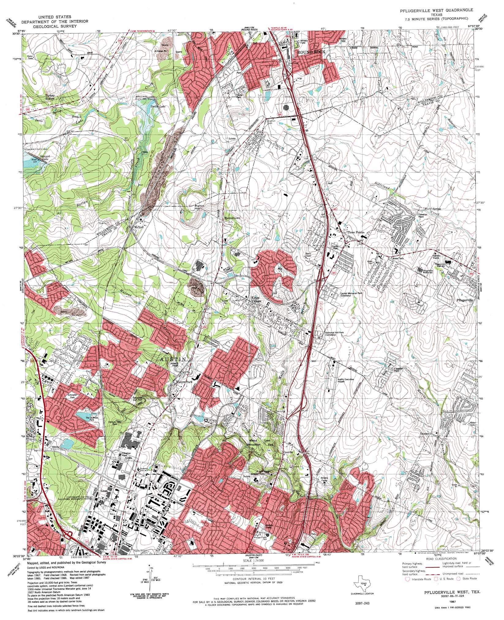
Pflugerville West Topo Map Texas
To zoom in, hover over the map of Pflugerville West
USGS Topo Quad 30097d6 - 1:24,000 scale
| Topo Map Name: | Pflugerville West |
| USGS Topo Quad ID: | 30097d6 |
| Print Size: | ca. 21 1/4" wide x 27" high |
| Southeast Coordinates: | 30.375° N latitude / 97.625° W longitude |
| Map Center Coordinates: | 30.4375° N latitude / 97.6875° W longitude |
| U.S. State: | TX |
| Filename: | o30097d6.jpg |
| Download Map JPG Image: | Pflugerville West topo map 1:24,000 scale |
| Map Type: | Topographic |
| Topo Series: | 7.5´ |
| Map Scale: | 1:24,000 |
| Source of Map Images: | United States Geological Survey (USGS) |
| Alternate Map Versions: |
Pflugerville West TX 1968, updated 1971 Download PDF Buy paper map Pflugerville West TX 1968, updated 1974 Download PDF Buy paper map Pflugerville West TX 1987, updated 1987 Download PDF Buy paper map Pflugerville West TX 1987, updated 1987 Download PDF Buy paper map Pflugerville West TX 2010 Download PDF Buy paper map Pflugerville West TX 2013 Download PDF Buy paper map Pflugerville West TX 2016 Download PDF Buy paper map |
1:24,000 Topo Quads surrounding Pflugerville West
Liberty Hill |
Leander Ne |
Georgetown |
Weir |
Granger |
Nameless |
Leander |
Round Rock |
Hutto |
Taylor |
Mansfield Dam |
Jollyville |
Pflugerville West |
Pflugerville East |
Coupland |
Bee Cave |
Austin West |
Austin East |
Manor |
Elgin West |
Signal Hill |
Oak Hill |
Montopolis |
Webberville |
Utley |
> Back to 30097a1 at 1:100,000 scale
> Back to 30096a1 at 1:250,000 scale
> Back to U.S. Topo Maps home
Pflugerville West topo map: Gazetteer
Pflugerville West: Airports
Austin Executive Airpark elevation 225m 738′Pflugerville West: Crossings
Interchange 243 elevation 222m 728′Interchange 244 elevation 202m 662′
Interchange 245 elevation 222m 728′
Interchange 246 elevation 242m 793′
Interchange 247 elevation 243m 797′
Interchange 248 elevation 255m 836′
Interchange 250 elevation 251m 823′
Interchange 251 elevation 243m 797′
Interchange 252A elevation 225m 738′
Pflugerville West: Dams
Mesa Park Quarries Dam elevation 243m 797′Soil Conservation Service Site 8 Dam elevation 256m 839′
Soil Conservation Service Site 9 Dam elevation 239m 784′
Pflugerville West: Parks
Austin Raceway Park elevation 264m 866′Balcones Community Park elevation 225m 738′
Chisholm Valley Park elevation 234m 767′
Connally Stadium elevation 227m 744′
Creekmont West Park elevation 228m 748′
Frontier Park elevation 238m 780′
Katherine Fleischer Park elevation 244m 800′
Kenningham Park elevation 228m 748′
Kuempel Stadium elevation 234m 767′
North Creek Park elevation 259m 849′
North Oaks Park elevation 211m 692′
Schroeter Park elevation 258m 846′
Walnut Creek Metropolitan Park elevation 196m 643′
Pflugerville West: Populated Places
Coxville elevation 213m 698′Dessau elevation 205m 672′
Dessau Fountains elevation 227m 744′
Eubank Acres elevation 223m 731′
Idyle Hour Acres elevation 225m 738′
Kings Village elevation 253m 830′
McNeil elevation 253m 830′
Merrelltown elevation 258m 846′
Three Points elevation 251m 823′
Turkey Hollow elevation 251m 823′
Walnut Forest elevation 210m 688′
Ward Spring elevation 222m 728′
Waters Park elevation 218m 715′
Wells Branch elevation 250m 820′
Windemere elevation 231m 757′
Pflugerville West: Post Offices
Pflugerville Post Office elevation 242m 793′Pflugerville West: Reservoirs
Ganzert Lake elevation 253m 830′Smith Lake elevation 239m 784′
Soil Conservation Service Site 8 Reservoir elevation 256m 839′
Soil Conservation Service Site 9 Reservoir elevation 239m 784′
Pflugerville West: Springs
Roger Spring elevation 240m 787′Pflugerville West: Streams
Davis Spring Branch elevation 240m 787′Rattan Creek elevation 225m 738′
Tar Branch elevation 187m 613′
Wells Branch elevation 184m 603′
Pflugerville West: Summits
Martin Hill elevation 284m 931′Pflugerville West: Trails
Balcones Park Trail elevation 241m 790′Gracywoods Park Trail elevation 205m 672′
Pflugerville Trail elevation 235m 770′
Pflugerville West digital topo map on disk
Buy this Pflugerville West topo map showing relief, roads, GPS coordinates and other geographical features, as a high-resolution digital map file on DVD: