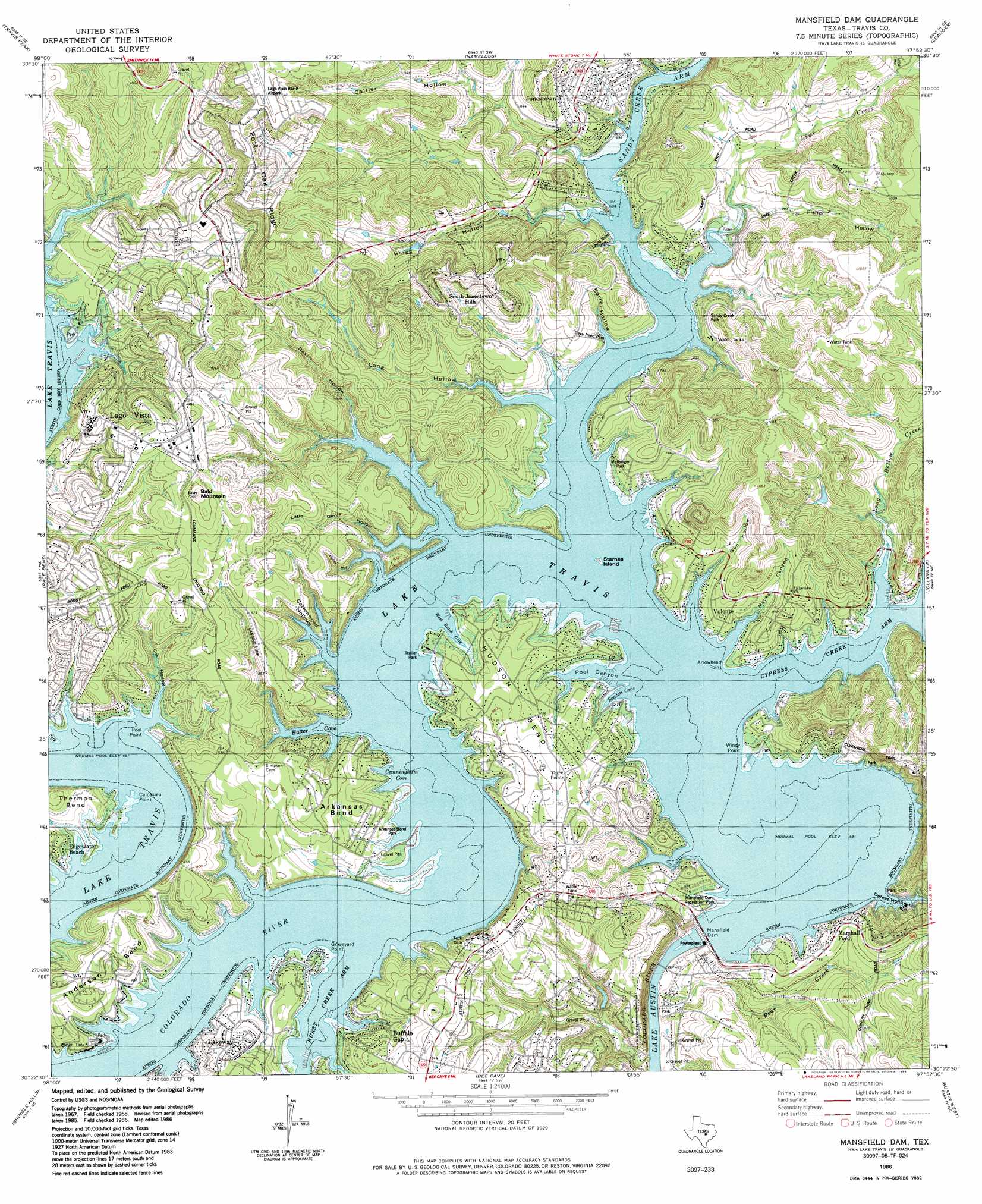
Mansfield Dam Topo Map Texas
To zoom in, hover over the map of Mansfield Dam
USGS Topo Quad 30097d8 - 1:24,000 scale
| Topo Map Name: | Mansfield Dam |
| USGS Topo Quad ID: | 30097d8 |
| Print Size: | ca. 21 1/4" wide x 27" high |
| Southeast Coordinates: | 30.375° N latitude / 97.875° W longitude |
| Map Center Coordinates: | 30.4375° N latitude / 97.9375° W longitude |
| U.S. State: | TX |
| Filename: | o30097d8.jpg |
| Download Map JPG Image: | Mansfield Dam topo map 1:24,000 scale |
| Map Type: | Topographic |
| Topo Series: | 7.5´ |
| Map Scale: | 1:24,000 |
| Source of Map Images: | United States Geological Survey (USGS) |
| Alternate Map Versions: |
Mansfield Dam TX 1968, updated 1971 Download PDF Buy paper map Mansfield Dam TX 1968, updated 1975 Download PDF Buy paper map Mansfield Dam TX 1968, updated 1986 Download PDF Buy paper map Mansfield Dam TX 1986, updated 1986 Download PDF Buy paper map Mansfield Dam TX 2010 Download PDF Buy paper map Mansfield Dam TX 2013 Download PDF Buy paper map Mansfield Dam TX 2016 Download PDF Buy paper map |
1:24,000 Topo Quads surrounding Mansfield Dam
Mormon Mill |
Bertram |
Liberty Hill |
Leander Ne |
Georgetown |
Smithwick |
Travis Peak |
Nameless |
Leander |
Round Rock |
Spicewood |
Pace Bend |
Mansfield Dam |
Jollyville |
Pflugerville West |
Hammetts Crossing |
Shingle Hills |
Bee Cave |
Austin West |
Austin East |
Henly |
Dripping Springs |
Signal Hill |
Oak Hill |
Montopolis |
> Back to 30097a1 at 1:100,000 scale
> Back to 30096a1 at 1:250,000 scale
> Back to U.S. Topo Maps home
Mansfield Dam topo map: Gazetteer
Mansfield Dam: Airports
Lago Vista Bar-K Airpark elevation 371m 1217′Winns Heliport elevation 222m 728′
Mansfield Dam: Bays
Beacon Cove elevation 208m 682′Cunningham Cove elevation 208m 682′
Cypress Creek Arm elevation 208m 682′
Hatter Cove elevation 208m 682′
Hurst Creek Arm elevation 208m 682′
Sandy Creek Arm elevation 208m 682′
West Beach Cove elevation 210m 688′
Mansfield Dam: Bends
Anderson Bend elevation 251m 823′Arkansas Bend elevation 243m 797′
Hudson Bend elevation 225m 738′
Mansfield Dam: Capes
Arrowhead Point elevation 218m 715′Calcasieu Point elevation 212m 695′
Graveyard Point elevation 218m 715′
Pool Point elevation 219m 718′
Windy Point elevation 218m 715′
Mansfield Dam: Dams
Apache Lake Dam elevation 188m 616′Mansfield Dam elevation 213m 698′
Marshall Ford Dam elevation 214m 702′
Mansfield Dam: Islands
Starnes Island elevation 208m 682′Mansfield Dam: Parks
Arkansas Bend Park elevation 218m 715′Bar K Park elevation 211m 692′
Bob Wentz - Windy Point Park elevation 218m 715′
Dave Reed Park elevation 238m 780′
Fritz Hughes Park elevation 166m 544′
Lago Vista Stadium elevation 263m 862′
Laura Reed Park elevation 230m 754′
Mansfield Dam Recreation Park elevation 222m 728′
McGregor Park elevation 223m 731′
Sandy Creek Park elevation 231m 757′
Tom Hughes Park elevation 225m 738′
Mansfield Dam: Populated Places
Buffalo Gap elevation 229m 751′Edgewater Beach elevation 224m 734′
Hudson Bend elevation 230m 754′
Jonestown elevation 248m 813′
Lago Vista elevation 236m 774′
Marshall Ford elevation 238m 780′
North Shore Acres elevation 245m 803′
Point Venture elevation 226m 741′
South Jonestown Hills elevation 256m 839′
Volente elevation 242m 793′
Mansfield Dam: Reservoirs
Apache Lake elevation 188m 616′Lake Travis elevation 214m 702′
Lake Travis elevation 208m 682′
Mansfield Dam: Streams
Bear Creek elevation 153m 501′Lime Creek elevation 213m 698′
Long Hollow Creek elevation 208m 682′
Mansfield Dam: Summits
Bald Mountain elevation 323m 1059′Comanche Peak elevation 325m 1066′
Mansfield Dam: Trails
Arkansas Bend Trail elevation 218m 715′Mansfield Dam: Valleys
Barrel Hollow elevation 209m 685′Collier Hollow elevation 212m 695′
Cottonwood Hollows elevation 208m 682′
Cox Hollow elevation 212m 695′
Defeat Hollow elevation 208m 682′
Devils Hollow elevation 208m 682′
Fisher Hollow elevation 216m 708′
Gragg Hollow elevation 208m 682′
Gun Hollow elevation 218m 715′
Little Devils Hollow elevation 208m 682′
Long Hollow elevation 208m 682′
Long Hollow elevation 256m 839′
Macks Canyon elevation 208m 682′
Mossy Hollow elevation 208m 682′
Pool Canyon elevation 208m 682′
Mansfield Dam digital topo map on disk
Buy this Mansfield Dam topo map showing relief, roads, GPS coordinates and other geographical features, as a high-resolution digital map file on DVD: