Thorndale Topo Map Texas
To zoom in, hover over the map of Thorndale
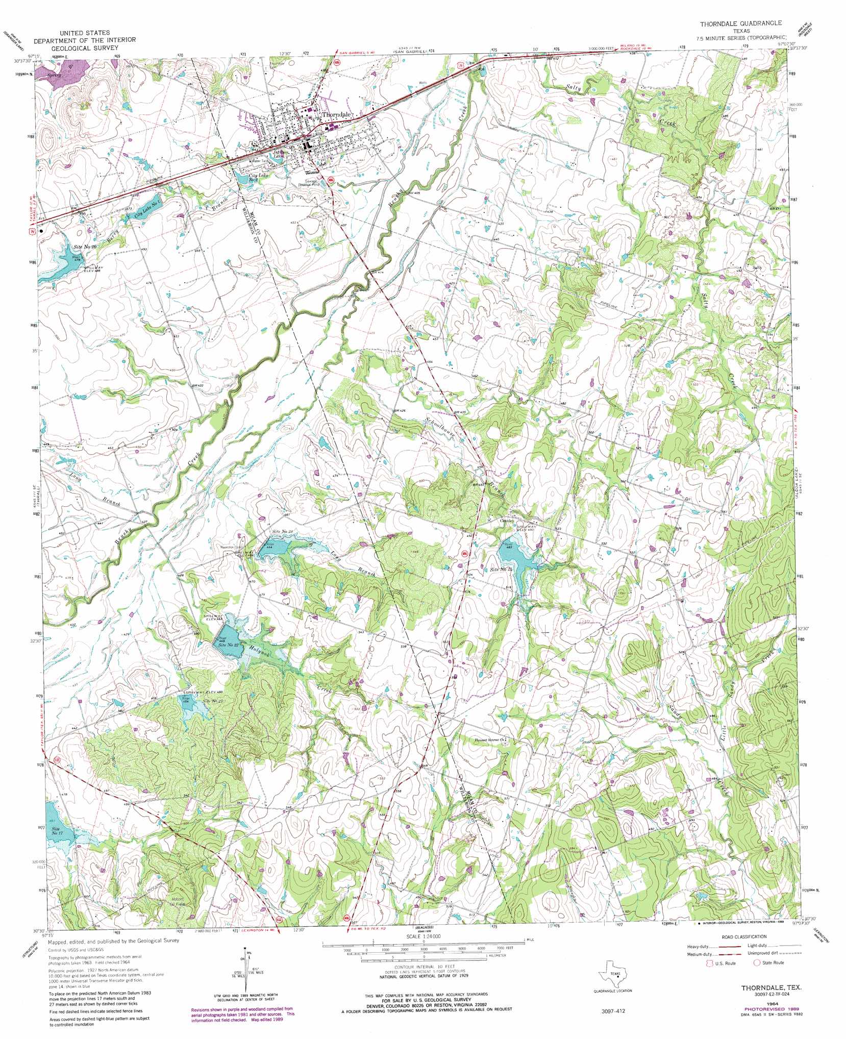
USGS Topo Quad 30097e2 - 1:24,000 scale
| Topo Map Name: | Thorndale |
| USGS Topo Quad ID: | 30097e2 |
| Print Size: | ca. 21 1/4" wide x 27" high |
| Southeast Coordinates: | 30.5° N latitude / 97.125° W longitude |
| Map Center Coordinates: | 30.5625° N latitude / 97.1875° W longitude |
| U.S. State: | TX |
| Filename: | o30097e2.jpg |
| Download Map JPG Image: | Thorndale topo map 1:24,000 scale |
| Map Type: | Topographic |
| Topo Series: | 7.5´ |
| Map Scale: | 1:24,000 |
| Source of Map Images: | United States Geological Survey (USGS) |
| Alternate Map Versions: |
Thorndale TX 1964, updated 1966 Download PDF Buy paper map Thorndale TX 1964, updated 1989 Download PDF Buy paper map Thorndale TX 2010 Download PDF Buy paper map Thorndale TX 2012 Download PDF Buy paper map Thorndale TX 2016 Download PDF Buy paper map |
1:24,000 Topo Quads surrounding Thorndale
Bartlett |
Davilla |
Sharp |
Pettibone |
Cameron |
Granger |
Friendship |
San Gabriel |
Rockdale West |
Rockdale East |
Taylor |
Thrall |
Thorndale |
Alcoa Lake |
Hicks |
Coupland |
Structure |
Beaukiss |
Lexington |
Tanglewood |
Elgin West |
Elgin East |
Mcdade |
Fedor |
Lincoln |
> Back to 30097e1 at 1:100,000 scale
> Back to 30096a1 at 1:250,000 scale
> Back to U.S. Topo Maps home
Thorndale topo map: Gazetteer
Thorndale: Dams
City Lake Number 1 Dam elevation 140m 459′Soil Conservation Service Site 20 Dam elevation 149m 488′
Soil Conservation Service Site 21 Dam elevation 141m 462′
Soil Conservation Service Site 22 Dam elevation 135m 442′
Soil Conservation Service Site 23 Dam elevation 137m 449′
Soil Conservation Service Site 24 Dam elevation 148m 485′
Thorndale: Lakes
Jackson Lake elevation 131m 429′Thorndale: Populated Places
Conoley elevation 151m 495′Salty elevation 152m 498′
Thorndale elevation 138m 452′
Thorndale: Reservoirs
City Lake Number 1 elevation 140m 459′City Lake Number One elevation 140m 459′
City Lake Number Two elevation 131m 429′
Site Number Twenty elevation 149m 488′
Site Number Twentyfour elevation 149m 488′
Site Number Twentyone elevation 141m 462′
Site Number Twentythree elevation 138m 452′
Site Number Twentytwo elevation 137m 449′
Soil Conservation Service Site 20 Reservoir elevation 149m 488′
Soil Conservation Service Site 21 Reservoir elevation 141m 462′
Soil Conservation Service Site 22 Reservoir elevation 135m 442′
Soil Conservation Service Site 23 Reservoir elevation 137m 449′
Soil Conservation Service Site 24 Reservoir elevation 148m 485′
Thorndale: Streams
Berry Branch elevation 122m 400′Holynok Creek elevation 124m 406′
Little Sandy Creek elevation 140m 459′
Long Branch elevation 127m 416′
Long Branch elevation 127m 416′
Schoolhouse Branch elevation 120m 393′
Thorndale digital topo map on disk
Buy this Thorndale topo map showing relief, roads, GPS coordinates and other geographical features, as a high-resolution digital map file on DVD: