Round Rock Topo Map Texas
To zoom in, hover over the map of Round Rock
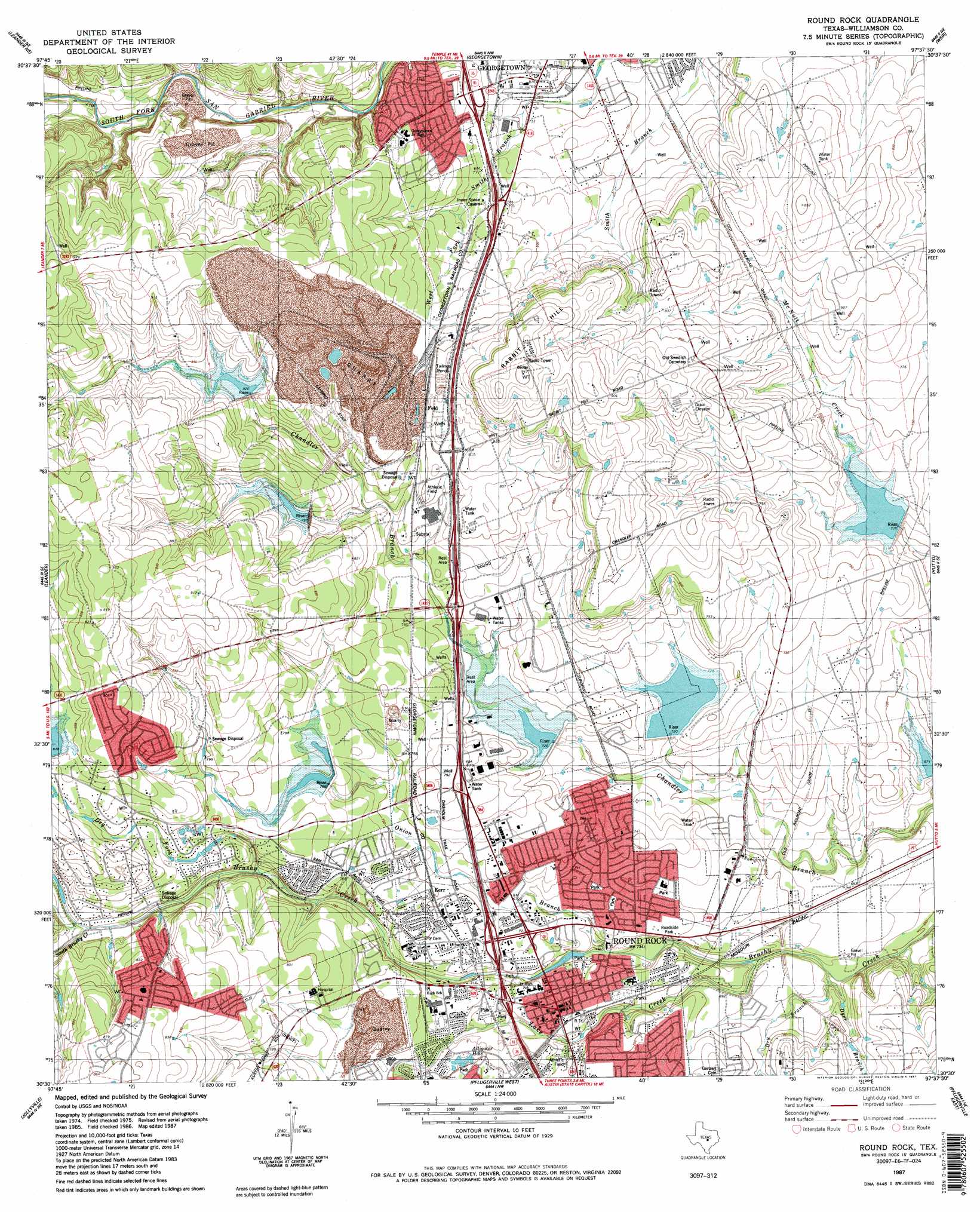
USGS Topo Quad 30097e6 - 1:24,000 scale
| Topo Map Name: | Round Rock |
| USGS Topo Quad ID: | 30097e6 |
| Print Size: | ca. 21 1/4" wide x 27" high |
| Southeast Coordinates: | 30.5° N latitude / 97.625° W longitude |
| Map Center Coordinates: | 30.5625° N latitude / 97.6875° W longitude |
| U.S. State: | TX |
| Filename: | o30097e6.jpg |
| Download Map JPG Image: | Round Rock topo map 1:24,000 scale |
| Map Type: | Topographic |
| Topo Series: | 7.5´ |
| Map Scale: | 1:24,000 |
| Source of Map Images: | United States Geological Survey (USGS) |
| Alternate Map Versions: |
Round Rock TX 1982, updated 1982 Download PDF Buy paper map Round Rock TX 1987, updated 1987 Download PDF Buy paper map Round Rock TX 1987, updated 1987 Download PDF Buy paper map Round Rock TX 2010 Download PDF Buy paper map Round Rock TX 2013 Download PDF Buy paper map Round Rock TX 2016 Download PDF Buy paper map |
1:24,000 Topo Quads surrounding Round Rock
Mahomet |
Florence |
Cobbs Cavern |
Jarrell |
Bartlett |
Liberty Hill |
Leander Ne |
Georgetown |
Weir |
Granger |
Nameless |
Leander |
Round Rock |
Hutto |
Taylor |
Mansfield Dam |
Jollyville |
Pflugerville West |
Pflugerville East |
Coupland |
Bee Cave |
Austin West |
Austin East |
Manor |
Elgin West |
> Back to 30097e1 at 1:100,000 scale
> Back to 30096a1 at 1:250,000 scale
> Back to U.S. Topo Maps home
Round Rock topo map: Gazetteer
Round Rock: Airports
Green Airport elevation 262m 859′Tri-Modal Air Park elevation 268m 879′
Round Rock: Crossings
Interchange 252B elevation 223m 731′Interchange 253 elevation 223m 731′
Interchange 254 elevation 239m 784′
Round Rock: Dams
Soil Conservation Service Site 10a Dam elevation 257m 843′Soil Conservation Service Site 10b Dam elevation 246m 807′
Soil Conservation Service Site 11 Dam elevation 217m 711′
Soil Conservation Service Site 12 Dam elevation 228m 748′
Soil Conservation Service Site 14 Dam elevation 220m 721′
Soil Conservation Service Site 16 Dam elevation 222m 728′
Soil Conservation Service Site 17 Dam elevation 205m 672′
Walsh Lake Dam elevation 234m 767′
Round Rock: Parks
Bustin Memorial Park elevation 222m 728′Dell Diamond elevation 207m 679′
Dragon Stadium elevation 227m 744′
Egger Park elevation 222m 728′
Lake Creek Park elevation 216m 708′
Mesa Village Park elevation 223m 731′
Old Settlers Park elevation 221m 725′
Round Rock High School Softball Field elevation 221m 725′
Roundrock West Park elevation 224m 734′
Stark Park elevation 220m 721′
Stella Park elevation 224m 734′
Round Rock: Populated Places
Brushy Creek elevation 252m 826′Old Round Rock (historical) elevation 218m 715′
Round Rock elevation 224m 734′
Round Rock: Post Offices
Round Rock Post Office and William M Owen House elevation 223m 731′Round Rock: Reservoirs
Soil Conservation Service Site 10a Reservoir elevation 257m 843′Soil Conservation Service Site 10b Reservoir elevation 246m 807′
Soil Conservation Service Site 11 Reservoir elevation 217m 711′
Soil Conservation Service Site 12 Reservoir elevation 228m 748′
Soil Conservation Service Site 14 Reservoir elevation 220m 721′
Soil Conservation Service Site 16 Reservoir elevation 222m 728′
Soil Conservation Service Site 17 Reservoir elevation 205m 672′
Walsh Lake elevation 234m 767′
Round Rock: Streams
Dry Branch elevation 205m 672′Dry Fork Creek elevation 224m 734′
Dyer Branch elevation 204m 669′
Lake Creek elevation 202m 662′
Onion Branch elevation 210m 688′
South Brushy Creek elevation 231m 757′
Round Rock: Summits
Rabbit Hill elevation 263m 862′Round Rock digital topo map on disk
Buy this Round Rock topo map showing relief, roads, GPS coordinates and other geographical features, as a high-resolution digital map file on DVD: