Granger Topo Map Texas
To zoom in, hover over the map of Granger
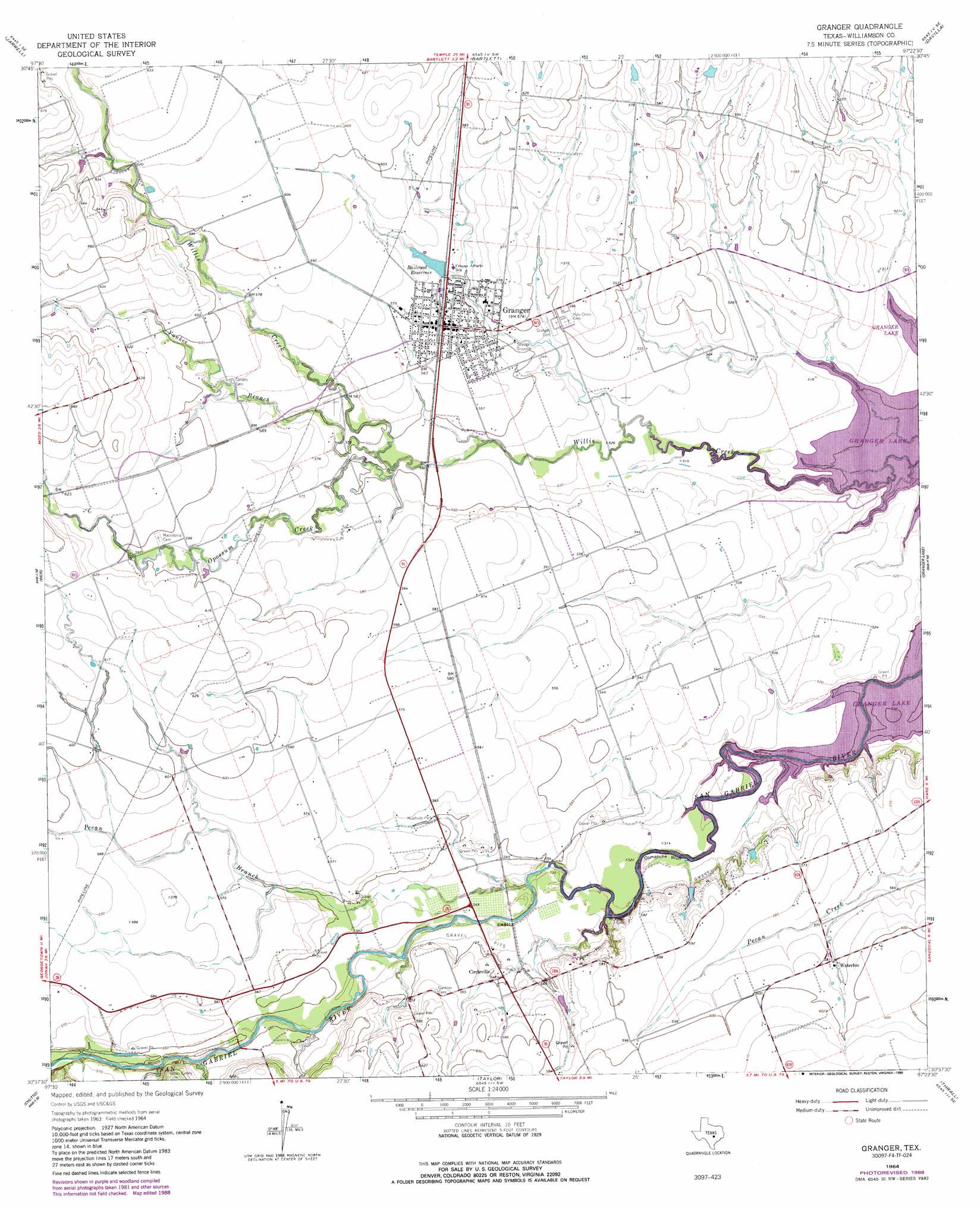
USGS Topo Quad 30097f4 - 1:24,000 scale
| Topo Map Name: | Granger |
| USGS Topo Quad ID: | 30097f4 |
| Print Size: | ca. 21 1/4" wide x 27" high |
| Southeast Coordinates: | 30.625° N latitude / 97.375° W longitude |
| Map Center Coordinates: | 30.6875° N latitude / 97.4375° W longitude |
| U.S. State: | TX |
| Filename: | o30097f4.jpg |
| Download Map JPG Image: | Granger topo map 1:24,000 scale |
| Map Type: | Topographic |
| Topo Series: | 7.5´ |
| Map Scale: | 1:24,000 |
| Source of Map Images: | United States Geological Survey (USGS) |
| Alternate Map Versions: |
Granger TX 1964, updated 1966 Download PDF Buy paper map Granger TX 1964, updated 1987 Download PDF Buy paper map Granger TX 1964, updated 1989 Download PDF Buy paper map Granger TX 2010 Download PDF Buy paper map Granger TX 2013 Download PDF Buy paper map Granger TX 2016 Download PDF Buy paper map |
1:24,000 Topo Quads surrounding Granger
Youngsport |
Salado |
Holland |
Little River |
Rogers |
Cobbs Cavern |
Jarrell |
Bartlett |
Davilla |
Sharp |
Georgetown |
Weir |
Granger |
Friendship |
San Gabriel |
Round Rock |
Hutto |
Taylor |
Thrall |
Thorndale |
Pflugerville West |
Pflugerville East |
Coupland |
Structure |
Beaukiss |
> Back to 30097e1 at 1:100,000 scale
> Back to 30096a1 at 1:250,000 scale
> Back to U.S. Topo Maps home
Granger topo map: Gazetteer
Granger: Airports
Vitek Field elevation 176m 577′Granger: Bridges
Hoxie Bridge elevation 143m 469′Granger: Cliffs
Comanche Bluff elevation 156m 511′Granger: Dams
Railroad Reservoir Dam elevation 170m 557′Granger: Parks
San Gabriel Wildlife Area elevation 160m 524′Willis Creek Park elevation 162m 531′
Willis Creek Wildlife Area elevation 159m 521′
Granger: Populated Places
Circleville elevation 166m 544′Granger elevation 176m 577′
Waterloo elevation 177m 580′
Granger: Reservoirs
Railroad Reservoir elevation 170m 557′Railroad Reservoir elevation 174m 570′
Granger: Streams
Opossum Creek elevation 164m 538′Pecan Branch elevation 159m 521′
Yankee Branch elevation 163m 534′
Granger digital topo map on disk
Buy this Granger topo map showing relief, roads, GPS coordinates and other geographical features, as a high-resolution digital map file on DVD: