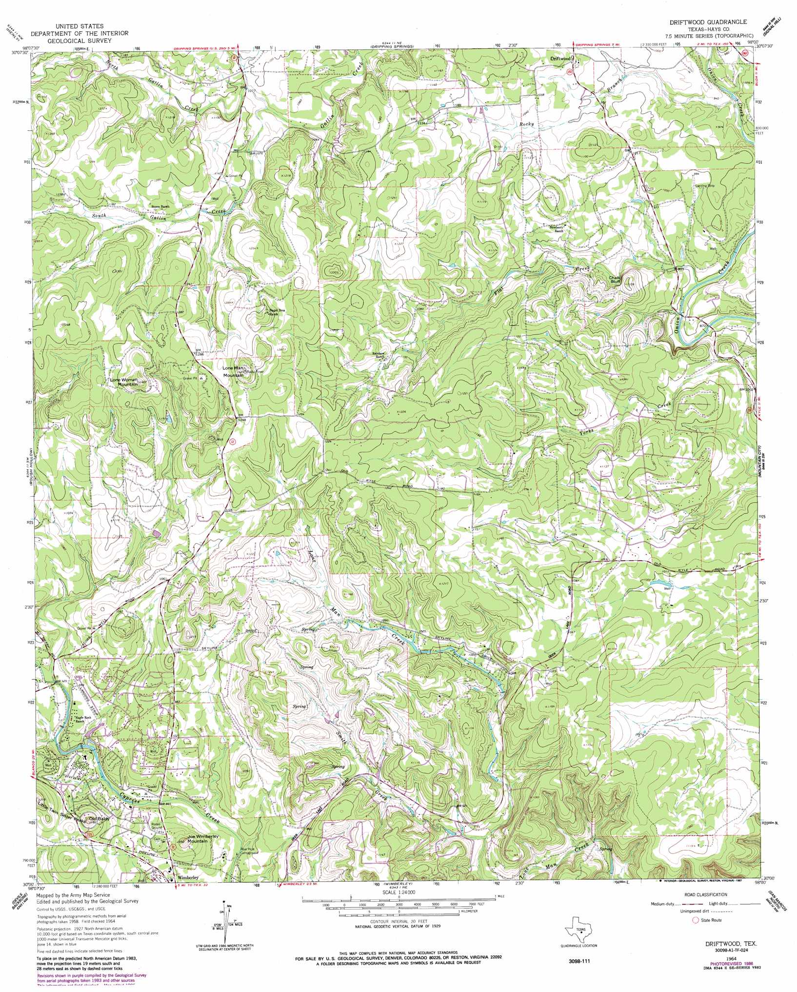
Driftwood Topo Map Texas
To zoom in, hover over the map of Driftwood
USGS Topo Quad 30098a1 - 1:24,000 scale
| Topo Map Name: | Driftwood |
| USGS Topo Quad ID: | 30098a1 |
| Print Size: | ca. 21 1/4" wide x 27" high |
| Southeast Coordinates: | 30° N latitude / 98° W longitude |
| Map Center Coordinates: | 30.0625° N latitude / 98.0625° W longitude |
| U.S. State: | TX |
| Filename: | o30098a1.jpg |
| Download Map JPG Image: | Driftwood topo map 1:24,000 scale |
| Map Type: | Topographic |
| Topo Series: | 7.5´ |
| Map Scale: | 1:24,000 |
| Source of Map Images: | United States Geological Survey (USGS) |
| Alternate Map Versions: |
Driftwood TX 1964, updated 1966 Download PDF Buy paper map Driftwood TX 1964, updated 1987 Download PDF Buy paper map Driftwood TX 1964, updated 1987 Download PDF Buy paper map Driftwood TX 2010 Download PDF Buy paper map Driftwood TX 2012 Download PDF Buy paper map Driftwood TX 2016 Download PDF Buy paper map |
1:24,000 Topo Quads surrounding Driftwood
Pedernales Falls |
Hammetts Crossing |
Shingle Hills |
Bee Cave |
Austin West |
Yeager Creek |
Henly |
Dripping Springs |
Signal Hill |
Oak Hill |
Payton |
Rough Hollow |
Driftwood |
Mountain City |
Buda |
Fischer |
Devils Backbone |
Wimberley |
San Marcos North |
Uhland |
Smithson Valley |
Sattler |
Hunter |
San Marcos South |
Martindale |
> Back to 30098a1 at 1:100,000 scale
> Back to 30098a1 at 1:250,000 scale
> Back to U.S. Topo Maps home
Driftwood topo map: Gazetteer
Driftwood: Airports
Woodcreek Resort Airport elevation 297m 974′Driftwood: Cliffs
Chalk Bluff elevation 325m 1066′Driftwood: Populated Places
Driftwood elevation 318m 1043′Woodcreek elevation 293m 961′
Driftwood: Streams
Flat Creek elevation 273m 895′North Gatlin Creek elevation 323m 1059′
Rocky Branch elevation 278m 912′
Smith Creek elevation 266m 872′
South Gatlin Creek elevation 323m 1059′
Driftwood: Summits
Joe Wimberley Mountain elevation 323m 1059′Little Twin Sister Peaks elevation 360m 1181′
Lone Man Mountain elevation 416m 1364′
Lone Woman Mountain elevation 423m 1387′
Old Baldy elevation 359m 1177′
Driftwood digital topo map on disk
Buy this Driftwood topo map showing relief, roads, GPS coordinates and other geographical features, as a high-resolution digital map file on DVD: