Monument Hill Topo Map Texas
To zoom in, hover over the map of Monument Hill
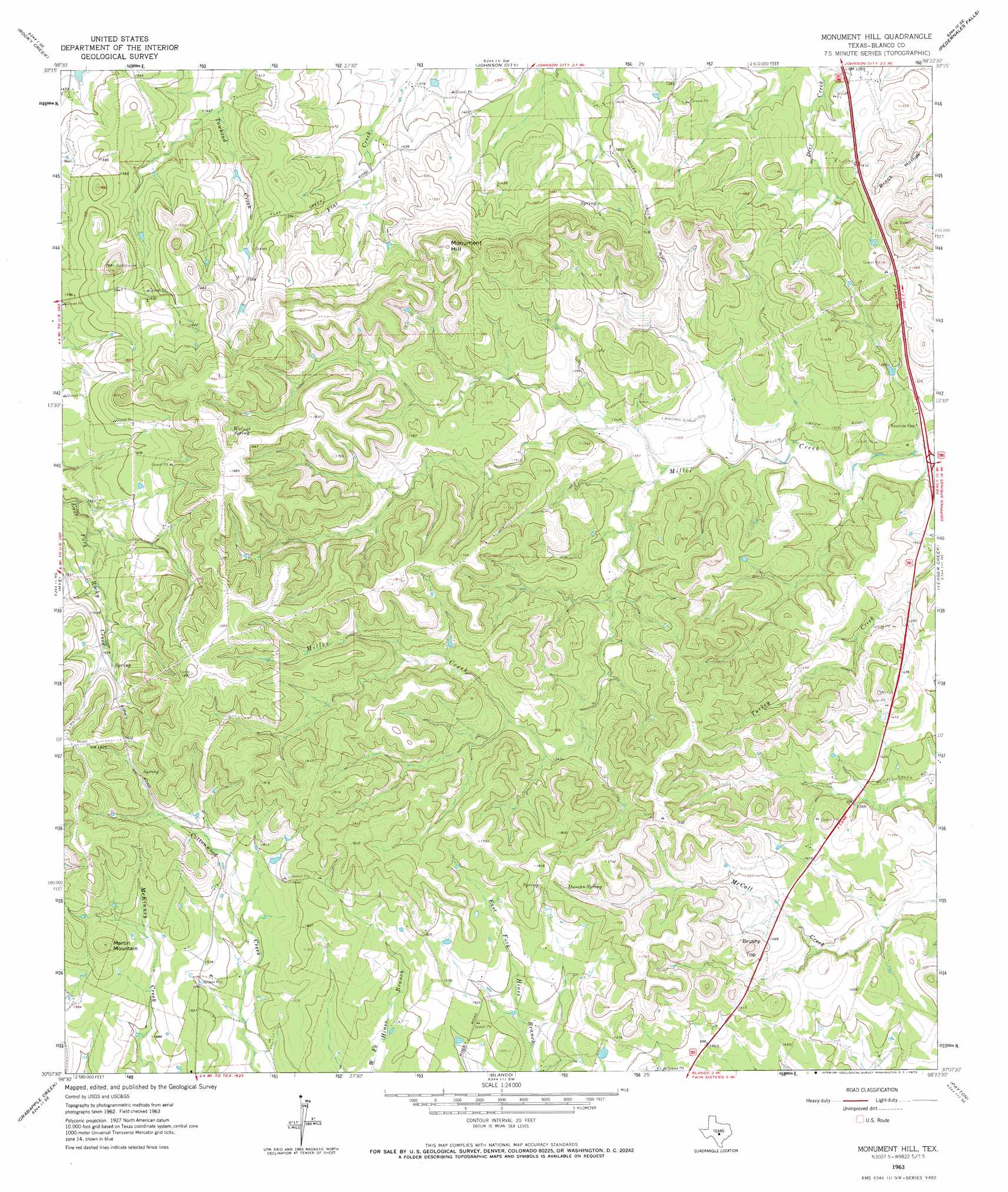
USGS Topo Quad 30098b4 - 1:24,000 scale
| Topo Map Name: | Monument Hill |
| USGS Topo Quad ID: | 30098b4 |
| Print Size: | ca. 21 1/4" wide x 27" high |
| Southeast Coordinates: | 30.125° N latitude / 98.375° W longitude |
| Map Center Coordinates: | 30.1875° N latitude / 98.4375° W longitude |
| U.S. State: | TX |
| Filename: | o30098b4.jpg |
| Download Map JPG Image: | Monument Hill topo map 1:24,000 scale |
| Map Type: | Topographic |
| Topo Series: | 7.5´ |
| Map Scale: | 1:24,000 |
| Source of Map Images: | United States Geological Survey (USGS) |
| Alternate Map Versions: |
Monument Hill TX 1963, updated 1965 Download PDF Buy paper map Monument Hill TX 1963, updated 1973 Download PDF Buy paper map Monument Hill TX 2010 Download PDF Buy paper map Monument Hill TX 2012 Download PDF Buy paper map Monument Hill TX 2016 Download PDF Buy paper map |
1:24,000 Topo Quads surrounding Monument Hill
Willow City |
Blowout |
Howell Mountain |
Round Mountain |
Spicewood |
Cave Creek School |
Rocky Creek |
Johnson City |
Pedernales Falls |
Hammetts Crossing |
Stonewall |
Hye |
Monument Hill |
Yeager Creek |
Henly |
Whitworth Ranch |
Crabapple Creek |
Blanco |
Payton |
Rough Hollow |
Sisterdale |
Kendalia |
Spring Branch |
Fischer |
Devils Backbone |
> Back to 30098a1 at 1:100,000 scale
> Back to 30098a1 at 1:250,000 scale
> Back to U.S. Topo Maps home
Monument Hill topo map: Gazetteer
Monument Hill: Airports
Bamberger Ranch Airport elevation 462m 1515′Charlie Thomas Ranch Airport elevation 447m 1466′
Keller Ranch Airport elevation 477m 1564′
Monument Hill: Dams
Tatum Lake Dam elevation 434m 1423′Monument Hill: Reservoirs
Tatum Lake elevation 434m 1423′Monument Hill: Springs
Duncan Spring elevation 526m 1725′Walnut Spring elevation 531m 1742′
Monument Hill: Summits
Brushy Top elevation 497m 1630′Martin Mountain elevation 546m 1791′
Monument Hill elevation 549m 1801′
Monument Hill digital topo map on disk
Buy this Monument Hill topo map showing relief, roads, GPS coordinates and other geographical features, as a high-resolution digital map file on DVD: