Travis Peak Topo Map Texas
To zoom in, hover over the map of Travis Peak
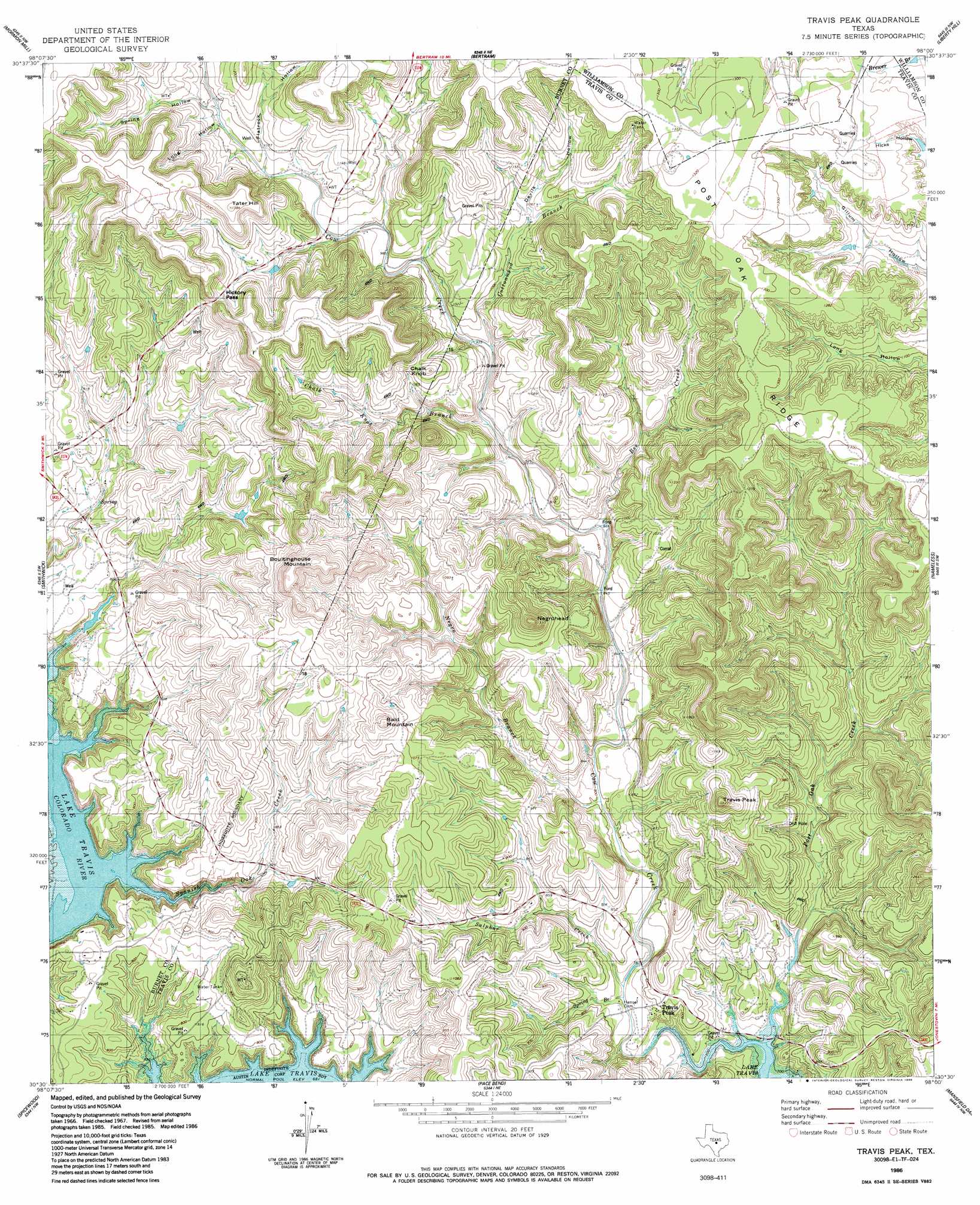
USGS Topo Quad 30098e1 - 1:24,000 scale
| Topo Map Name: | Travis Peak |
| USGS Topo Quad ID: | 30098e1 |
| Print Size: | ca. 21 1/4" wide x 27" high |
| Southeast Coordinates: | 30.5° N latitude / 98° W longitude |
| Map Center Coordinates: | 30.5625° N latitude / 98.0625° W longitude |
| U.S. State: | TX |
| Filename: | o30098e1.jpg |
| Download Map JPG Image: | Travis Peak topo map 1:24,000 scale |
| Map Type: | Topographic |
| Topo Series: | 7.5´ |
| Map Scale: | 1:24,000 |
| Source of Map Images: | United States Geological Survey (USGS) |
| Alternate Map Versions: |
Travis Peak TX 1966, updated 1969 Download PDF Buy paper map Travis Peak TX 1966, updated 1977 Download PDF Buy paper map Travis Peak TX 1986, updated 1986 Download PDF Buy paper map Travis Peak TX 1986, updated 1986 Download PDF Buy paper map Travis Peak TX 2010 Download PDF Buy paper map Travis Peak TX 2012 Download PDF Buy paper map Travis Peak TX 2016 Download PDF Buy paper map |
1:24,000 Topo Quads surrounding Travis Peak
Council Creek |
Burnet |
Joppa |
Mahomet |
Florence |
Longhorn Cavern |
Mormon Mill |
Bertram |
Liberty Hill |
Leander Ne |
Marble Falls |
Smithwick |
Travis Peak |
Nameless |
Leander |
Round Mountain |
Spicewood |
Pace Bend |
Mansfield Dam |
Jollyville |
Pedernales Falls |
Hammetts Crossing |
Shingle Hills |
Bee Cave |
Austin West |
> Back to 30098e1 at 1:100,000 scale
> Back to 30098a1 at 1:250,000 scale
> Back to U.S. Topo Maps home
Travis Peak topo map: Gazetteer
Travis Peak: Gaps
Hickory Pass elevation 382m 1253′Travis Peak: Ridges
Post Oak Ridge elevation 398m 1305′Travis Peak: Streams
Bee Creek elevation 263m 862′Chalk Knob Branch elevation 278m 912′
Cottonwood Branch elevation 293m 961′
Negro Branch elevation 238m 780′
Post Oak Creek elevation 208m 682′
Spanish Oak Creek elevation 208m 682′
Spring Branch elevation 224m 734′
Sulphur Creek elevation 224m 734′
Travis Peak: Summits
Bald Mountain elevation 383m 1256′Boultinghouse Mountain elevation 418m 1371′
Chalk Knob elevation 367m 1204′
Negrohead elevation 405m 1328′
Tater Hill elevation 422m 1384′
Travis Peak elevation 382m 1253′
Travis Peak: Trails
Turkey Bend Trail elevation 239m 784′Travis Peak: Valleys
Devils Hollow elevation 315m 1033′Flatrock Hollow elevation 323m 1059′
Long Hollow elevation 328m 1076′
Spring Hollow elevation 328m 1076′
Travis Peak digital topo map on disk
Buy this Travis Peak topo map showing relief, roads, GPS coordinates and other geographical features, as a high-resolution digital map file on DVD: