Marble Falls Topo Map Texas
To zoom in, hover over the map of Marble Falls
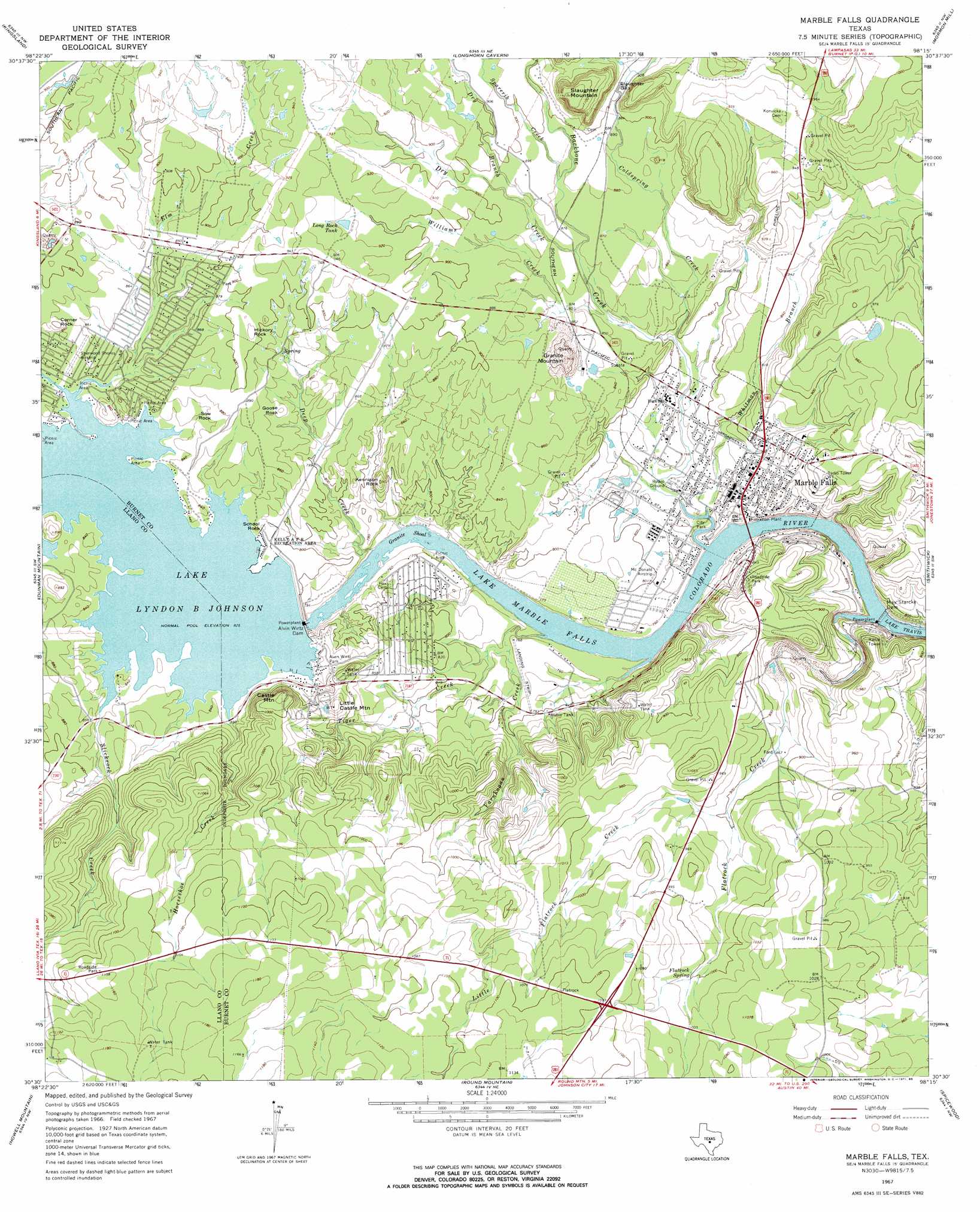
USGS Topo Quad 30098e3 - 1:24,000 scale
| Topo Map Name: | Marble Falls |
| USGS Topo Quad ID: | 30098e3 |
| Print Size: | ca. 21 1/4" wide x 27" high |
| Southeast Coordinates: | 30.5° N latitude / 98.25° W longitude |
| Map Center Coordinates: | 30.5625° N latitude / 98.3125° W longitude |
| U.S. State: | TX |
| Filename: | o30098e3.jpg |
| Download Map JPG Image: | Marble Falls topo map 1:24,000 scale |
| Map Type: | Topographic |
| Topo Series: | 7.5´ |
| Map Scale: | 1:24,000 |
| Source of Map Images: | United States Geological Survey (USGS) |
| Alternate Map Versions: |
Marble Falls TX 1967, updated 1971 Download PDF Buy paper map Marble Falls TX 1967, updated 1985 Download PDF Buy paper map Marble Falls TX 2010 Download PDF Buy paper map Marble Falls TX 2012 Download PDF Buy paper map Marble Falls TX 2016 Download PDF Buy paper map |
1:24,000 Topo Quads surrounding Marble Falls
Lone Grove |
Lake Buchanan |
Council Creek |
Burnet |
Joppa |
Cap Mountain |
Kingsland |
Longhorn Cavern |
Mormon Mill |
Bertram |
Click |
Dunman Mountain |
Marble Falls |
Smithwick |
Travis Peak |
Blowout |
Howell Mountain |
Round Mountain |
Spicewood |
Pace Bend |
Rocky Creek |
Johnson City |
Pedernales Falls |
Hammetts Crossing |
Shingle Hills |
> Back to 30098e1 at 1:100,000 scale
> Back to 30098a1 at 1:250,000 scale
> Back to U.S. Topo Maps home
Marble Falls topo map: Gazetteer
Marble Falls: Airports
Granite Shoals Municipal Airport elevation 256m 839′Horseshoe Bay Airpark elevation 332m 1089′
Slaughter Ranch Airport elevation 270m 885′
Marble Falls: Bars
Granite Shoal elevation 223m 731′Marble Falls: Dams
Alvin Wirtz Dam elevation 227m 744′Max Starcke Dam elevation 223m 731′
Meadowlakes Number 1 Dam elevation 231m 757′
Meadowlakes Number 2 Dam elevation 231m 757′
Marble Falls: Gaps
Slaughter Gap elevation 278m 912′Marble Falls: Parks
Alvin Wirtz Park elevation 257m 843′Kelly A F B Recreation Area elevation 252m 826′
Lakeside Park elevation 231m 757′
Marble Falls City Park elevation 228m 748′
Marble Falls High School Stadium elevation 252m 826′
Marble Falls: Pillars
Corner Rock elevation 276m 905′Goose Rock elevation 269m 882′
Hickory Rock elevation 281m 921′
School Rock elevation 256m 839′
Sow Rock elevation 265m 869′
Marble Falls: Populated Places
Cottonwood Shores elevation 253m 830′Horseshoe Bay elevation 258m 846′
Marble Falls elevation 251m 823′
Meadowlakes elevation 245m 803′
Sherwood Shores elevation 261m 856′
Marble Falls: Post Offices
Marble Falls Post Office elevation 257m 843′Marble Falls: Reservoirs
Lake Lyndon B Johnson elevation 227m 744′Lake Marble Falls elevation 211m 692′
Long Rock Tank elevation 280m 918′
Meadowlakes Number 1 Lake elevation 231m 757′
Meadowlakes Number 2 Lake elevation 231m 757′
Marble Falls: Springs
Flatrock Spring elevation 305m 1000′Marble Falls: Streams
Backbone Creek elevation 223m 731′Coldspring Creek elevation 237m 777′
Deep Creek elevation 223m 731′
Dry Branch elevation 263m 862′
Dry Creek elevation 258m 846′
Elm Creek elevation 252m 826′
Flatrock Creek elevation 223m 731′
Horseshoe Creek elevation 253m 830′
Little Flatrock Creek elevation 274m 898′
Slickrock Creek elevation 252m 826′
Sparerib Creek elevation 268m 879′
Tiger Creek elevation 227m 744′
Varnhagan Creek elevation 223m 731′
Whitman Branch elevation 226m 741′
Williams Creek elevation 248m 813′
Marble Falls: Summits
Castle Mountain elevation 320m 1049′Granite Mountain elevation 294m 964′
Kennison Rock elevation 270m 885′
Little Castle Mountain elevation 303m 994′
Slaughter Mountain elevation 347m 1138′
Marble Falls digital topo map on disk
Buy this Marble Falls topo map showing relief, roads, GPS coordinates and other geographical features, as a high-resolution digital map file on DVD: