Dunman Mountain Topo Map Texas
To zoom in, hover over the map of Dunman Mountain
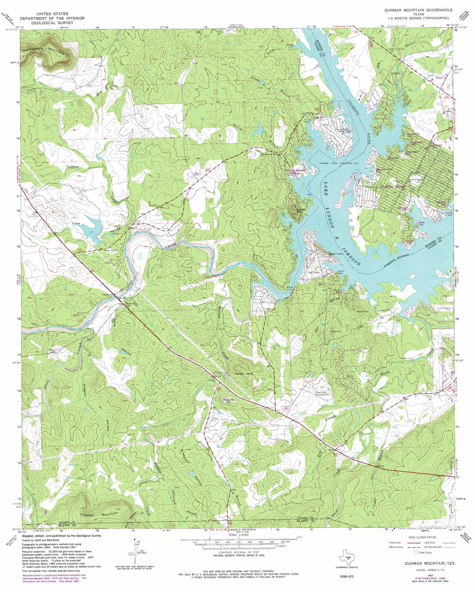
USGS Topo Quad 30098e4 - 1:24,000 scale
| Topo Map Name: | Dunman Mountain |
| USGS Topo Quad ID: | 30098e4 |
| Print Size: | ca. 21 1/4" wide x 27" high |
| Southeast Coordinates: | 30.5° N latitude / 98.375° W longitude |
| Map Center Coordinates: | 30.5625° N latitude / 98.4375° W longitude |
| U.S. State: | TX |
| Filename: | o30098e4.jpg |
| Download Map JPG Image: | Dunman Mountain topo map 1:24,000 scale |
| Map Type: | Topographic |
| Topo Series: | 7.5´ |
| Map Scale: | 1:24,000 |
| Source of Map Images: | United States Geological Survey (USGS) |
| Alternate Map Versions: |
Dunman Mountain TX 1967, updated 1970 Download PDF Buy paper map Dunman Mountain TX 1967, updated 1982 Download PDF Buy paper map Dunman Mountain TX 2010 Download PDF Buy paper map Dunman Mountain TX 2012 Download PDF Buy paper map Dunman Mountain TX 2016 Download PDF Buy paper map |
1:24,000 Topo Quads surrounding Dunman Mountain
Llano North |
Lone Grove |
Lake Buchanan |
Council Creek |
Burnet |
Llano South |
Cap Mountain |
Kingsland |
Longhorn Cavern |
Mormon Mill |
Oxford |
Click |
Dunman Mountain |
Marble Falls |
Smithwick |
Willow City |
Blowout |
Howell Mountain |
Round Mountain |
Spicewood |
Cave Creek School |
Rocky Creek |
Johnson City |
Pedernales Falls |
Hammetts Crossing |
> Back to 30098e1 at 1:100,000 scale
> Back to 30098a1 at 1:250,000 scale
> Back to U.S. Topo Maps home
Dunman Mountain topo map: Gazetteer
Dunman Mountain: Airports
Sunrise Beach Airport elevation 258m 846′Dunman Mountain: Dams
Barry Dam elevation 274m 898′Freight Development Company Lake Dam elevation 282m 925′
Dunman Mountain: Populated Places
Granite Shoals elevation 268m 879′Highland Haven elevation 257m 843′
Sunrise Beach Village elevation 257m 843′
Dunman Mountain: Post Offices
Horsehow Bay Post Office elevation 279m 915′Dunman Mountain: Reservoirs
Barry Lake elevation 274m 898′Freight Development Company Lake elevation 282m 925′
Dunman Mountain: Streams
Arant Creek elevation 252m 826′Cedar Branch elevation 280m 918′
Dry Branch elevation 268m 879′
Dry Creek elevation 252m 826′
Pecan Creek elevation 252m 826′
Richards Branch elevation 280m 918′
Sandy Branch elevation 252m 826′
Sandy Creek elevation 252m 826′
Spring Branch elevation 252m 826′
Station Creek elevation 254m 833′
Upshaw Creek elevation 259m 849′
Walnut Creek elevation 252m 826′
West Walnut Creek elevation 311m 1020′
White Creek elevation 268m 879′
Dunman Mountain: Summits
Dunman Mountain elevation 387m 1269′Hardin Hills elevation 317m 1040′
Little Sandy Mountain elevation 272m 892′
Mesquite Hill elevation 312m 1023′
Sandy Mountain elevation 316m 1036′
Dunman Mountain: Valleys
Buffalo Hollow elevation 285m 935′Deer Hollow elevation 254m 833′
Hogpen Hollow elevation 273m 895′
Larrimore Hollow elevation 303m 994′
Lime Hollow elevation 262m 859′
Ship Hollow elevation 264m 866′
Dunman Mountain digital topo map on disk
Buy this Dunman Mountain topo map showing relief, roads, GPS coordinates and other geographical features, as a high-resolution digital map file on DVD: