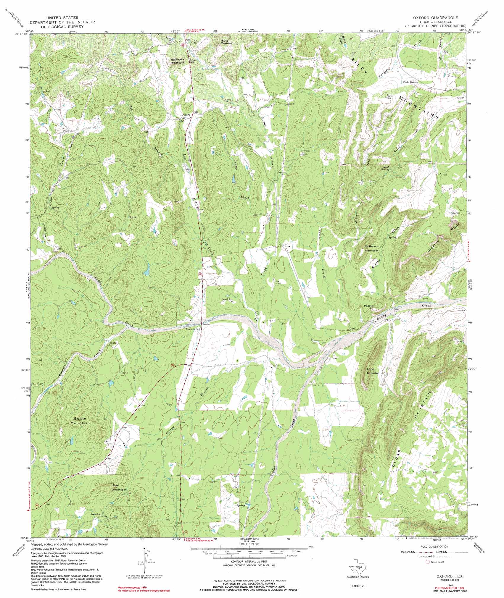
Oxford Topo Map Texas
To zoom in, hover over the map of Oxford
USGS Topo Quad 30098e6 - 1:24,000 scale
| Topo Map Name: | Oxford |
| USGS Topo Quad ID: | 30098e6 |
| Print Size: | ca. 21 1/4" wide x 27" high |
| Southeast Coordinates: | 30.5° N latitude / 98.625° W longitude |
| Map Center Coordinates: | 30.5625° N latitude / 98.6875° W longitude |
| U.S. State: | TX |
| Filename: | o30098e6.jpg |
| Download Map JPG Image: | Oxford topo map 1:24,000 scale |
| Map Type: | Topographic |
| Topo Series: | 7.5´ |
| Map Scale: | 1:24,000 |
| Source of Map Images: | United States Geological Survey (USGS) |
| Alternate Map Versions: |
Oxford TX 1967, updated 1969 Download PDF Buy paper map Oxford TX 1967, updated 1991 Download PDF Buy paper map Oxford TX 2010 Download PDF Buy paper map Oxford TX 2012 Download PDF Buy paper map Oxford TX 2016 Download PDF Buy paper map |
1:24,000 Topo Quads surrounding Oxford
Smoothingiron Mountain |
Valley Spring |
Llano North |
Lone Grove |
Lake Buchanan |
Castell |
Scotts Crossing |
Llano South |
Cap Mountain |
Kingsland |
House Mountain |
Enchanted Rock |
Oxford |
Click |
Dunman Mountain |
Cherry Mountain |
Crabapple |
Willow City |
Blowout |
Howell Mountain |
Fredericksburg West |
Fredericksburg East |
Cave Creek School |
Rocky Creek |
Johnson City |
> Back to 30098e1 at 1:100,000 scale
> Back to 30098a1 at 1:250,000 scale
> Back to U.S. Topo Maps home
Oxford topo map: Gazetteer
Oxford: Cliffs
Hickory Bluff elevation 460m 1509′Oxford: Gaps
Fool Gap elevation 418m 1371′Oxford: Populated Places
Oxford elevation 408m 1338′Oxford: Springs
Raab Spring elevation 433m 1420′Oxford: Streams
Crabapple Creek elevation 352m 1154′Crump Creek elevation 360m 1181′
Goldmine Creek elevation 364m 1194′
Grape Creek elevation 363m 1190′
Hog Branch elevation 378m 1240′
Hondo Creek elevation 341m 1118′
Johnson Creek elevation 331m 1085′
Legion Creek elevation 335m 1099′
Lost Hollow Creek elevation 341m 1118′
Riley Creek elevation 413m 1354′
Silver Creek elevation 334m 1095′
Willow Branch elevation 338m 1108′
Oxford: Summits
Bowie Mountain elevation 452m 1482′Cedar Mountain elevation 541m 1774′
Fool Mountain elevation 459m 1505′
Lone Mountain elevation 477m 1564′
McBrown Mountain elevation 455m 1492′
Pluto Mountain elevation 501m 1643′
Potato Hill elevation 415m 1361′
Railbrake Mountain elevation 483m 1584′
Oxford: Valleys
Coulee Hollow elevation 329m 1079′Oxford digital topo map on disk
Buy this Oxford topo map showing relief, roads, GPS coordinates and other geographical features, as a high-resolution digital map file on DVD: