Scotts Crossing Topo Map Texas
To zoom in, hover over the map of Scotts Crossing
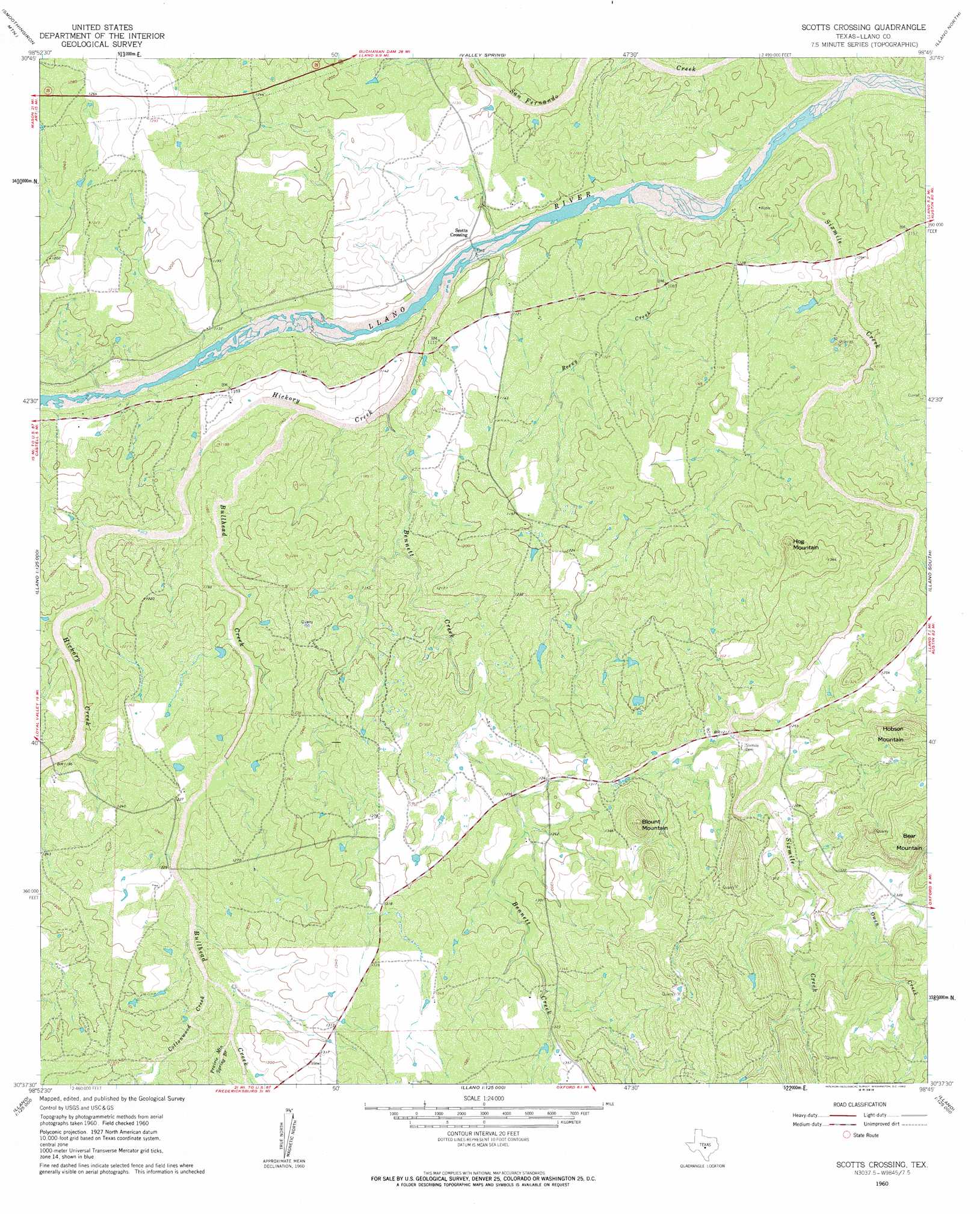
USGS Topo Quad 30098f7 - 1:24,000 scale
| Topo Map Name: | Scotts Crossing |
| USGS Topo Quad ID: | 30098f7 |
| Print Size: | ca. 21 1/4" wide x 27" high |
| Southeast Coordinates: | 30.625° N latitude / 98.75° W longitude |
| Map Center Coordinates: | 30.6875° N latitude / 98.8125° W longitude |
| U.S. State: | TX |
| Filename: | o30098f7.jpg |
| Download Map JPG Image: | Scotts Crossing topo map 1:24,000 scale |
| Map Type: | Topographic |
| Topo Series: | 7.5´ |
| Map Scale: | 1:24,000 |
| Source of Map Images: | United States Geological Survey (USGS) |
| Alternate Map Versions: |
Scotts Crossing TX 1960, updated 1962 Download PDF Buy paper map Scotts Crossing TX 2010 Download PDF Buy paper map Scotts Crossing TX 2012 Download PDF Buy paper map Scotts Crossing TX 2016 Download PDF Buy paper map |
1:24,000 Topo Quads surrounding Scotts Crossing
Fredonia |
Pontotoc |
Magill Mountain |
Cherokee |
Indian Hills |
Fly Gap |
Smoothingiron Mountain |
Valley Spring |
Llano North |
Lone Grove |
Art |
Castell |
Scotts Crossing |
Llano South |
Cap Mountain |
Loyal Valley |
House Mountain |
Enchanted Rock |
Oxford |
Click |
Cherry Spring |
Cherry Mountain |
Crabapple |
Willow City |
Blowout |
> Back to 30098e1 at 1:100,000 scale
> Back to 30098a1 at 1:250,000 scale
> Back to U.S. Topo Maps home
Scotts Crossing topo map: Gazetteer
Scotts Crossing: Populated Places
Scotts Crossing elevation 333m 1092′Scotts Crossing: Streams
Bennett Creek elevation 335m 1099′Bullhead Creek elevation 340m 1115′
Cottonwood Creek elevation 378m 1240′
Hickory Creek elevation 329m 1079′
Owen Creek elevation 387m 1269′
Prairie Mountain Spring Branch elevation 383m 1256′
Rocky Creek elevation 325m 1066′
San Fernando Creek elevation 314m 1030′
Sixmile Creek elevation 316m 1036′
Scotts Crossing: Summits
Bear Mountain elevation 470m 1541′Blount Mountain elevation 459m 1505′
Hobson Mountain elevation 469m 1538′
Hog Mountain elevation 415m 1361′
Scotts Crossing digital topo map on disk
Buy this Scotts Crossing topo map showing relief, roads, GPS coordinates and other geographical features, as a high-resolution digital map file on DVD: