Smoothingiron Mountain Topo Map Texas
To zoom in, hover over the map of Smoothingiron Mountain
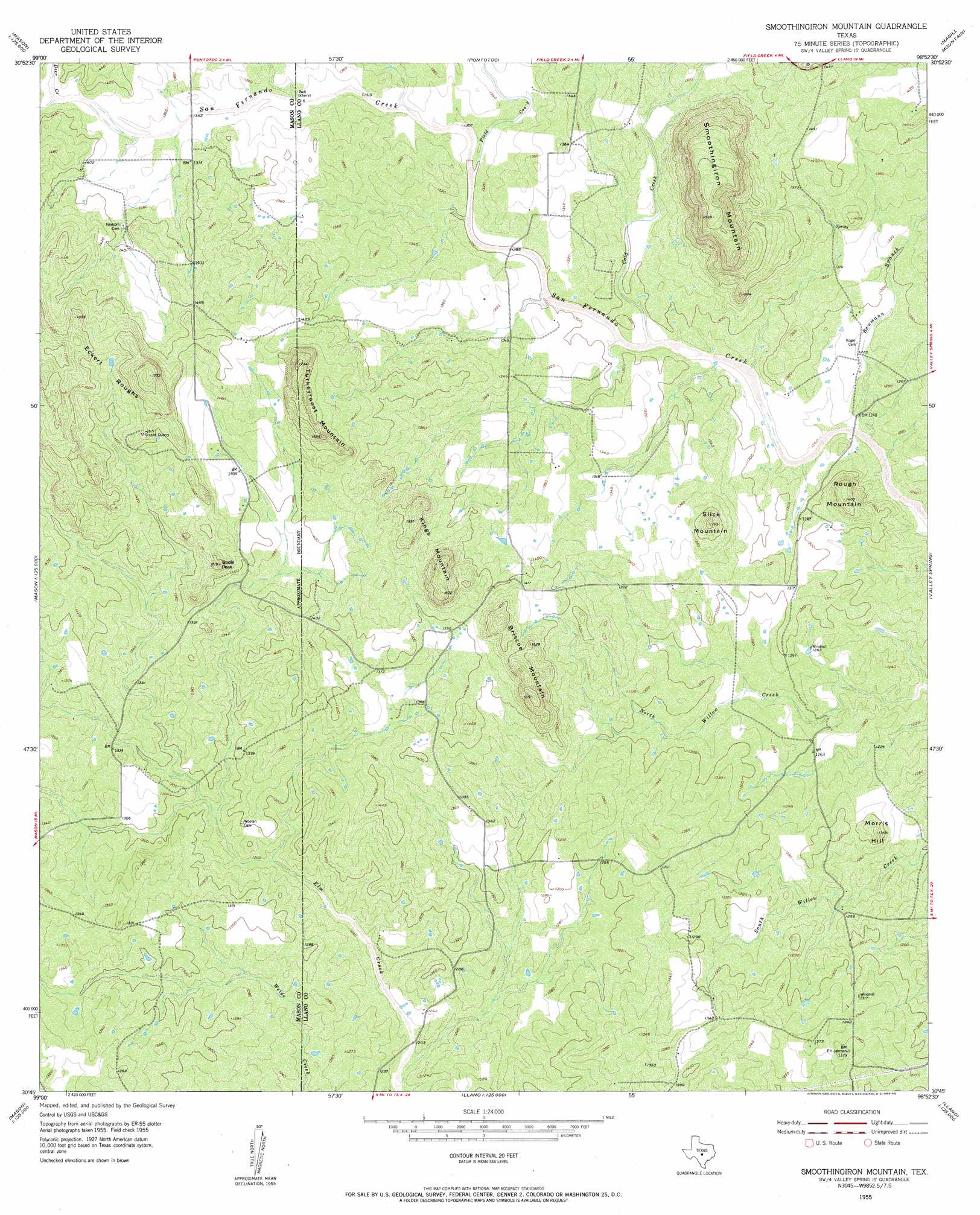
USGS Topo Quad 30098g8 - 1:24,000 scale
| Topo Map Name: | Smoothingiron Mountain |
| USGS Topo Quad ID: | 30098g8 |
| Print Size: | ca. 21 1/4" wide x 27" high |
| Southeast Coordinates: | 30.75° N latitude / 98.875° W longitude |
| Map Center Coordinates: | 30.8125° N latitude / 98.9375° W longitude |
| U.S. State: | TX |
| Filename: | o30098g8.jpg |
| Download Map JPG Image: | Smoothingiron Mountain topo map 1:24,000 scale |
| Map Type: | Topographic |
| Topo Series: | 7.5´ |
| Map Scale: | 1:24,000 |
| Source of Map Images: | United States Geological Survey (USGS) |
| Alternate Map Versions: |
Smoothingiron Mountain TX 1955, updated 1956 Download PDF Buy paper map Smoothingiron Mountain TX 1955, updated 1956 Download PDF Buy paper map Smoothingiron Mountain TX 2010 Download PDF Buy paper map Smoothingiron Mountain TX 2012 Download PDF Buy paper map Smoothingiron Mountain TX 2016 Download PDF Buy paper map |
1:24,000 Topo Quads surrounding Smoothingiron Mountain
Voca |
Pecan Springs |
Brady Mountain |
Buffalo Knob |
Bear Hollow |
Spy Rock |
Fredonia |
Pontotoc |
Magill Mountain |
Cherokee |
Purdy Hill |
Fly Gap |
Smoothingiron Mountain |
Valley Spring |
Llano North |
Mason |
Art |
Castell |
Scotts Crossing |
Llano South |
Panther Creek |
Loyal Valley |
House Mountain |
Enchanted Rock |
Oxford |
> Back to 30098e1 at 1:100,000 scale
> Back to 30098a1 at 1:250,000 scale
> Back to U.S. Topo Maps home
Smoothingiron Mountain topo map: Gazetteer
Smoothingiron Mountain: Streams
Baumann Branch elevation 375m 1230′Cold Creek elevation 389m 1276′
Field Creek elevation 396m 1299′
North Fork San Fernando Creek elevation 415m 1361′
South Fork San Fernando Creek elevation 415m 1361′
Smoothingiron Mountain: Summits
Bodie Peak elevation 486m 1594′Briscoe Mountain elevation 500m 1640′
Kings Mountain elevation 509m 1669′
Morris Hill elevation 414m 1358′
Rough Mountain elevation 447m 1466′
Slick Mountain elevation 464m 1522′
Smoothingiron Mountain elevation 556m 1824′
Turkeyroost Mountain elevation 524m 1719′
Smoothingiron Mountain digital topo map on disk
Buy this Smoothingiron Mountain topo map showing relief, roads, GPS coordinates and other geographical features, as a high-resolution digital map file on DVD: