Boneyard Draw Topo Map Texas
To zoom in, hover over the map of Boneyard Draw
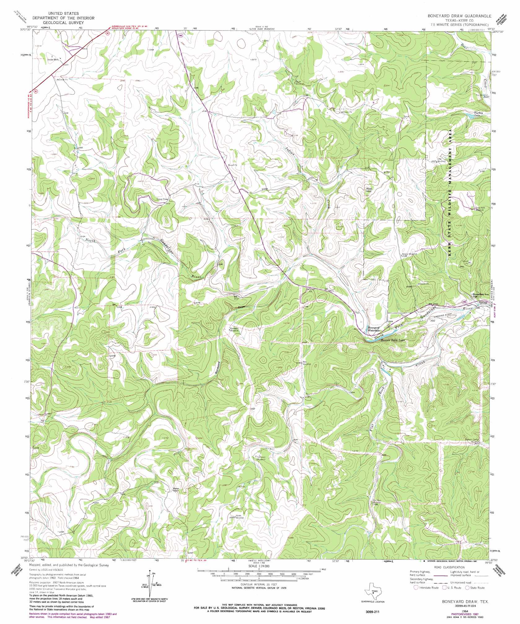
USGS Topo Quad 30099a5 - 1:24,000 scale
| Topo Map Name: | Boneyard Draw |
| USGS Topo Quad ID: | 30099a5 |
| Print Size: | ca. 21 1/4" wide x 27" high |
| Southeast Coordinates: | 30° N latitude / 99.5° W longitude |
| Map Center Coordinates: | 30.0625° N latitude / 99.5625° W longitude |
| U.S. State: | TX |
| Filename: | o30099a5.jpg |
| Download Map JPG Image: | Boneyard Draw topo map 1:24,000 scale |
| Map Type: | Topographic |
| Topo Series: | 7.5´ |
| Map Scale: | 1:24,000 |
| Source of Map Images: | United States Geological Survey (USGS) |
| Alternate Map Versions: |
Boneyard Draw TX 1964, updated 1966 Download PDF Buy paper map Boneyard Draw TX 1964, updated 1987 Download PDF Buy paper map Boneyard Draw TX 2010 Download PDF Buy paper map Boneyard Draw TX 2013 Download PDF Buy paper map Boneyard Draw TX 2016 Download PDF Buy paper map |
1:24,000 Topo Quads surrounding Boneyard Draw
Junction Se |
Allen Creek |
Mudge Draw |
Old Noxville |
Harper West |
Horse Camp Waterhole |
Y O Ranch |
Live Oak Ranch |
Contrary Creek |
Mountain Home |
Earwood Creek |
Garven Store |
Boneyard Draw |
Bee Caves Creek |
Hunt |
Bee Cave Hollow |
Hillcrest Ranch |
Well Hollow |
Diamond S Ranch |
Echo Hill Ranch |
Owl Hollow |
Circle Bluff |
Sabinal Canyon |
Love Creek |
A Bar A Ranch |
> Back to 30099a1 at 1:100,000 scale
> Back to 30098a1 at 1:250,000 scale
> Back to U.S. Topo Maps home
Boneyard Draw topo map: Gazetteer
Boneyard Draw: Airports
Stowers Ranch Airport elevation 608m 1994′Boneyard Draw: Lakes
Boneyard Waterhole elevation 603m 1978′Bonnie Belle Lake elevation 601m 1971′
Boneyard Draw: Parks
Kerr Wildlife Management Area elevation 650m 2132′Boneyard Draw: Populated Places
Stowers Corner Windmill elevation 630m 2066′Boneyard Draw: Reservoirs
Turkey Lake elevation 633m 2076′Boneyard Draw: Springs
Fish and Wildlife Springs elevation 635m 2083′Boneyard Draw: Streams
Flat Rock Creek elevation 594m 1948′Indian Creek elevation 609m 1998′
Boneyard Draw: Summits
Red Hill elevation 679m 2227′Boneyard Draw: Valleys
Boneyard Draw elevation 615m 2017′Boneyard Draw digital topo map on disk
Buy this Boneyard Draw topo map showing relief, roads, GPS coordinates and other geographical features, as a high-resolution digital map file on DVD: