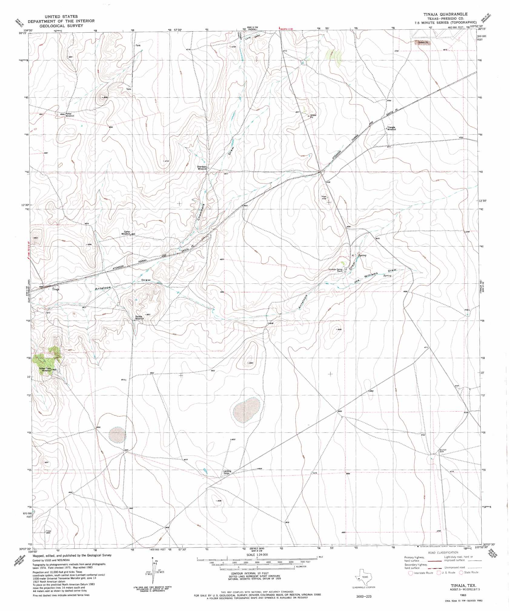
Tinaja Topo Map Texas
To zoom in, hover over the map of Tinaja
USGS Topo Quad 30103b8 - 1:24,000 scale
| Topo Map Name: | Tinaja |
| USGS Topo Quad ID: | 30103b8 |
| Print Size: | ca. 21 1/4" wide x 27" high |
| Southeast Coordinates: | 30.125° N latitude / 103.875° W longitude |
| Map Center Coordinates: | 30.1875° N latitude / 103.9375° W longitude |
| U.S. State: | TX |
| Filename: | o30103b8.jpg |
| Download Map JPG Image: | Tinaja topo map 1:24,000 scale |
| Map Type: | Topographic |
| Topo Series: | 7.5´ |
| Map Scale: | 1:24,000 |
| Source of Map Images: | United States Geological Survey (USGS) |
| Alternate Map Versions: |
Tinaja TX 1983, updated 1983 Download PDF Buy paper map Tinaja TX 2010 Download PDF Buy paper map Tinaja TX 2012 Download PDF Buy paper map Tinaja TX 2016 Download PDF Buy paper map |
1:24,000 Topo Quads surrounding Tinaja
Burro Draw |
Smith Hills |
Mano Prieto Mountain |
Mitre Peak |
Alpine North |
Aragon |
Marfa |
Nopal |
Paisano |
Alpine South |
Oak Creek |
San Estaban Lake |
Tinaja |
Tinaja Ne |
Cathedral Mountain |
San Estaban Lake Sw |
Frenchman Hills |
Devils Den |
Cactus Flat |
Goat Mountain |
Cerros Priestos |
Plata Ne |
Jordan Gap |
Paradise Draw |
Duff Springs |
> Back to 30103a1 at 1:100,000 scale
> Back to 30102a1 at 1:250,000 scale
> Back to U.S. Topo Maps home
Tinaja topo map: Gazetteer
Tinaja: Airports
Alta Vista Ranch Airport elevation 1434m 4704′Tinaja: Arroyos
Chambers Draw elevation 1384m 4540′Tinaja: Populated Places
Tinaja elevation 1380m 4527′Tinaja: Springs
Antelope Springs elevation 1428m 4685′Tinaja: Streams
Long Draw elevation 1425m 4675′Tinaja: Valleys
Colquitt Draw elevation 1425m 4675′Colquitt Draw elevation 1384m 4540′
Long Draw elevation 1425m 4675′
Tinaja digital topo map on disk
Buy this Tinaja topo map showing relief, roads, GPS coordinates and other geographical features, as a high-resolution digital map file on DVD: