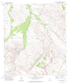
Big Aguja Mountain Topo Map Texas
To zoom in, hover over the map of Big Aguja Mountain
USGS Topo Quad 30103g7 - 1:24,000 scale
| Topo Map Name: | Big Aguja Mountain |
| USGS Topo Quad ID: | 30103g7 |
| Print Size: | ca. 21 1/4" wide x 27" high |
| Southeast Coordinates: | 30.75° N latitude / 103.75° W longitude |
| Map Center Coordinates: | 30.8125° N latitude / 103.8125° W longitude |
| U.S. State: | TX |
| Filename: | o30103g7.jpg |
| Download Map JPG Image: | Big Aguja Mountain topo map 1:24,000 scale |
| Map Type: | Topographic |
| Topo Series: | 7.5´ |
| Map Scale: | 1:24,000 |
| Source of Map Images: | United States Geological Survey (USGS) |
| Alternate Map Versions: |
Big Aguja Mountain TX 1972, updated 1974 Download PDF Buy paper map Big Aguja Mountain TX 2010 Download PDF Buy paper map Big Aguja Mountain TX 2012 Download PDF Buy paper map Big Aguja Mountain TX 2016 Download PDF Buy paper map |
1:24,000 Topo Quads surrounding Big Aguja Mountain
> Back to 30103e1 at 1:100,000 scale
> Back to 30102a1 at 1:250,000 scale
> Back to U.S. Topo Maps home
Big Aguja Mountain topo map: Gazetteer
Big Aguja Mountain: Dams
T and P Railroad Lake Dam elevation 1520m 4986′Big Aguja Mountain: Lakes
T and P Lake elevation 1232m 4041′Big Aguja Mountain: Reservoirs
Big Tank elevation 1157m 3795′Catfish Tank elevation 1170m 3838′
Company Tank elevation 1559m 5114′
Little Hell Tank elevation 1218m 3996′
T and P Lake elevation 1520m 4986′
Big Aguja Mountain: Springs
Augustine Spring elevation 1113m 3651′Big Aguja Springs elevation 1378m 4520′
Cottonwood Spring elevation 1108m 3635′
Cow Heaven Spring elevation 1363m 4471′
Dark Canyon Springs elevation 1236m 4055′
Dual Spring elevation 1133m 3717′
Ojo Grande Spring elevation 1289m 4229′
Old Camp Spring elevation 1108m 3635′
Seven Springs elevation 1162m 3812′
Walnut Spring elevation 1252m 4107′
Big Aguja Mountain: Summits
Big Aguja Mountain elevation 1710m 5610′Star Mountain elevation 1935m 6348′
Big Aguja Mountain: Valleys
Catclaw Canyon elevation 1264m 4146′Dry Canyon elevation 1292m 4238′
Second Water Canyon elevation 1295m 4248′
Big Aguja Mountain digital topo map on disk
Buy this Big Aguja Mountain topo map showing relief, roads, GPS coordinates and other geographical features, as a high-resolution digital map file on DVD:


