Little Aguja Mountain Topo Map Texas
To zoom in, hover over the map of Little Aguja Mountain
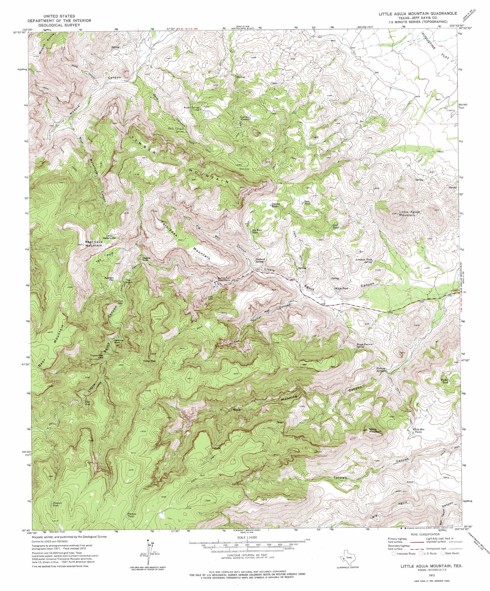
USGS Topo Quad 30103g8 - 1:24,000 scale
| Topo Map Name: | Little Aguja Mountain |
| USGS Topo Quad ID: | 30103g8 |
| Print Size: | ca. 21 1/4" wide x 27" high |
| Southeast Coordinates: | 30.75° N latitude / 103.875° W longitude |
| Map Center Coordinates: | 30.8125° N latitude / 103.9375° W longitude |
| U.S. State: | TX |
| Filename: | o30103g8.jpg |
| Download Map JPG Image: | Little Aguja Mountain topo map 1:24,000 scale |
| Map Type: | Topographic |
| Topo Series: | 7.5´ |
| Map Scale: | 1:24,000 |
| Source of Map Images: | United States Geological Survey (USGS) |
| Alternate Map Versions: |
Little Aguja Mountain TX 1972, updated 1975 Download PDF Buy paper map Little Aguja Mountain TX 2010 Download PDF Buy paper map Little Aguja Mountain TX 2012 Download PDF Buy paper map Little Aguja Mountain TX 2016 Download PDF Buy paper map |
1:24,000 Topo Quads surrounding Little Aguja Mountain
Kent |
Gomez Peak |
Sotol Hill |
Meier Hills |
Saragosa |
Echo Canyon |
Buckhorn Mountain |
Antelope Flat |
Toyahvale |
Balmorhea |
Robbers Roost Canyon |
Friend Mountain |
Little Aguja Mountain |
Big Aguja Mountain |
Barrilla Mountains West |
Mount Livermore |
Mount Locke |
Casket Mountain |
Swayback Mountain |
Major Peak |
Paradise Mountain |
Blue Mountain |
Fort Davis |
Fort Davis Se |
Henderson Mesa |
> Back to 30103e1 at 1:100,000 scale
> Back to 30102a1 at 1:250,000 scale
> Back to U.S. Topo Maps home
Little Aguja Mountain topo map: Gazetteer
Little Aguja Mountain: Flats
Ezras Bedground elevation 1740m 5708′Rustlers Flat elevation 1567m 5141′
The Park elevation 1624m 5328′
Trickey Gap Park elevation 1529m 5016′
Little Aguja Mountain: Gaps
The Notch elevation 1460m 4790′Trickey Gap elevation 1853m 6079′
Little Aguja Mountain: Lakes
Blue Hole elevation 1558m 5111′Little Aguja Mountain: Pillars
Balance Rock elevation 1545m 5068′Needle Rock elevation 1465m 4806′
Little Aguja Mountain: Reservoirs
Big Bear Tank elevation 1510m 4954′Carmac Tank elevation 1892m 6207′
Deer Tank elevation 1497m 4911′
Jack Tank elevation 1361m 4465′
Jimenez Tank elevation 1913m 6276′
Laguna Tank elevation 1526m 5006′
Walker Tank elevation 1616m 5301′
White Mountain Tanks elevation 1460m 4790′
White Tank elevation 1284m 4212′
Little Aguja Mountain: Springs
Airplane Tank Spring elevation 1294m 4245′Dark Canyon Spring elevation 1449m 4753′
Fishing Springs elevation 1274m 4179′
House Pasture Spring elevation 1437m 4714′
Orchard Spring elevation 1382m 4534′
Little Aguja Mountain: Summits
Bear Cave Mountain elevation 1952m 6404′Bear Mountain elevation 1970m 6463′
Forbidden Mountain elevation 1684m 5524′
Little Aguja Mountain elevation 1548m 5078′
Timber Mountain elevation 1947m 6387′
White Mountain elevation 1788m 5866′
Little Aguja Mountain: Valleys
Bear Canyon elevation 1351m 4432′Blue Waterhouse Canyon elevation 1329m 4360′
Bob Manning Canyon elevation 1230m 4035′
Dark Canyon elevation 1278m 4192′
Million Dollar Canyon elevation 1293m 4242′
Pig Pen Canyon elevation 1327m 4353′
Wood Canyon elevation 1324m 4343′
Little Aguja Mountain digital topo map on disk
Buy this Little Aguja Mountain topo map showing relief, roads, GPS coordinates and other geographical features, as a high-resolution digital map file on DVD: