Paradise Mountain Topo Map Texas
To zoom in, hover over the map of Paradise Mountain
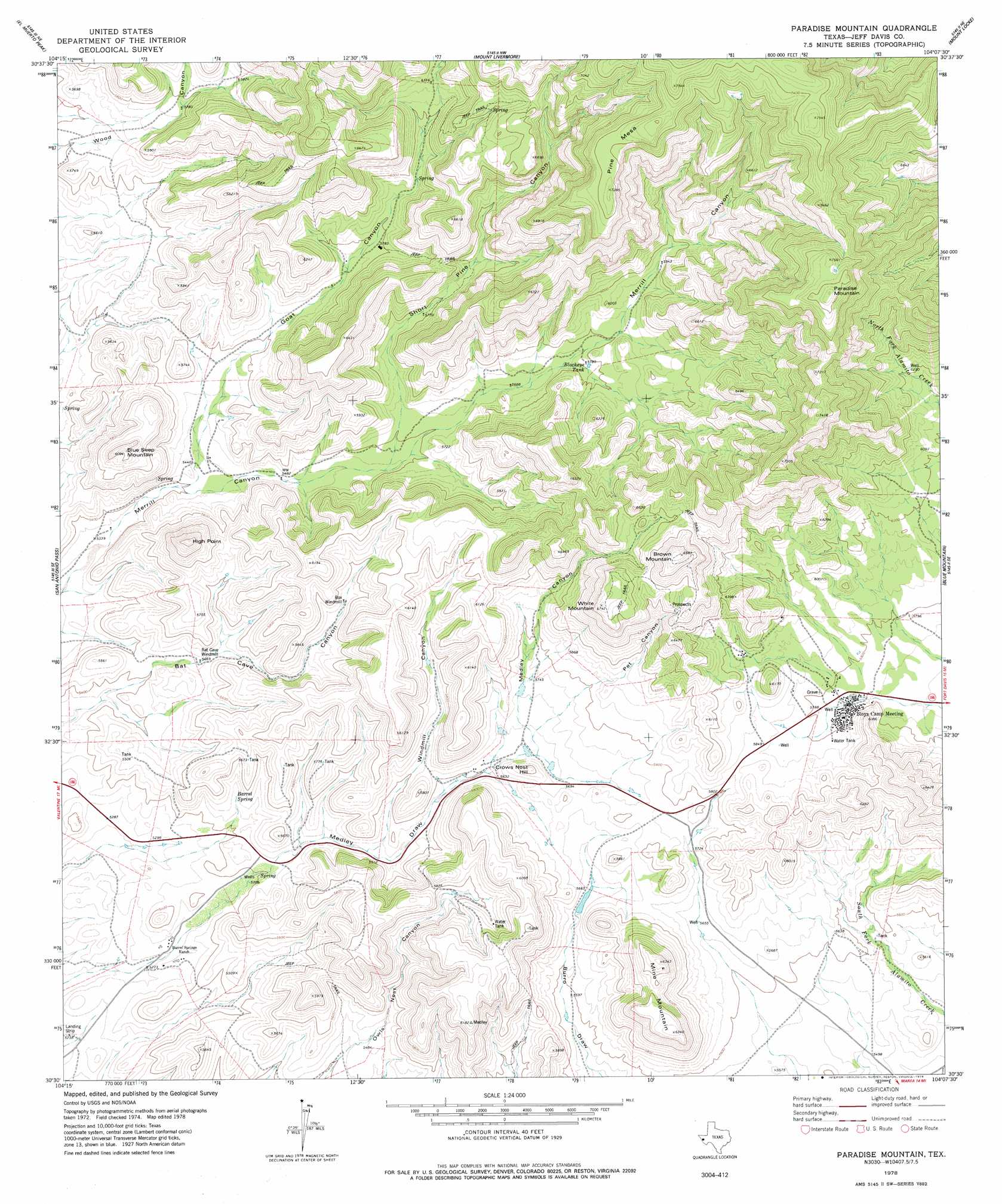
USGS Topo Quad 30104e2 - 1:24,000 scale
| Topo Map Name: | Paradise Mountain |
| USGS Topo Quad ID: | 30104e2 |
| Print Size: | ca. 21 1/4" wide x 27" high |
| Southeast Coordinates: | 30.5° N latitude / 104.125° W longitude |
| Map Center Coordinates: | 30.5625° N latitude / 104.1875° W longitude |
| U.S. State: | TX |
| Filename: | o30104e2.jpg |
| Download Map JPG Image: | Paradise Mountain topo map 1:24,000 scale |
| Map Type: | Topographic |
| Topo Series: | 7.5´ |
| Map Scale: | 1:24,000 |
| Source of Map Images: | United States Geological Survey (USGS) |
| Alternate Map Versions: |
Paradise Mountain TX 1978, updated 1978 Download PDF Buy paper map Paradise Mountain TX 2010 Download PDF Buy paper map Paradise Mountain TX 2012 Download PDF Buy paper map Paradise Mountain TX 2016 Download PDF Buy paper map |
1:24,000 Topo Quads surrounding Paradise Mountain
Boggy Draw |
Bare Mountain |
Robbers Roost Canyon |
Friend Mountain |
Little Aguja Mountain |
Horseshoe Butte |
El Muerto Peak |
Mount Livermore |
Mount Locke |
Casket Mountain |
Valentine East |
San Antonio Pass |
Paradise Mountain |
Blue Mountain |
Fort Davis |
Deer Peak |
Ryan |
Burro Draw |
Smith Hills |
Mano Prieto Mountain |
Ryan Sw |
Oak Hills North |
Aragon |
Marfa |
Nopal |
> Back to 30104e1 at 1:100,000 scale
> Back to 30104a1 at 1:250,000 scale
> Back to U.S. Topo Maps home
Paradise Mountain topo map: Gazetteer
Paradise Mountain: Reservoirs
Blackeye Tank elevation 1762m 5780′Paradise Mountain: Springs
Barrel Spring elevation 1669m 5475′Barrel Springs elevation 1681m 5515′
Paradise Mountain: Summits
Blue Seep Mountain elevation 1858m 6095′Brown Mountain elevation 2126m 6975′
Crows Nest Hill elevation 1782m 5846′
High Point elevation 1911m 6269′
Mine Mountain elevation 1930m 6332′
Paradise Mountain elevation 2354m 7723′
Pine Mesa elevation 2223m 7293′
White Mountain elevation 2051m 6729′
Paradise Mountain: Valleys
Goat Canyon elevation 1656m 5433′Medley Canyon elevation 1732m 5682′
Pet Canyon elevation 1799m 5902′
Short Pine Canyon elevation 1707m 5600′
Windmill Canyon elevation 1682m 5518′
Paradise Mountain digital topo map on disk
Buy this Paradise Mountain topo map showing relief, roads, GPS coordinates and other geographical features, as a high-resolution digital map file on DVD: