Buckhorn Mountain Topo Map Texas
To zoom in, hover over the map of Buckhorn Mountain
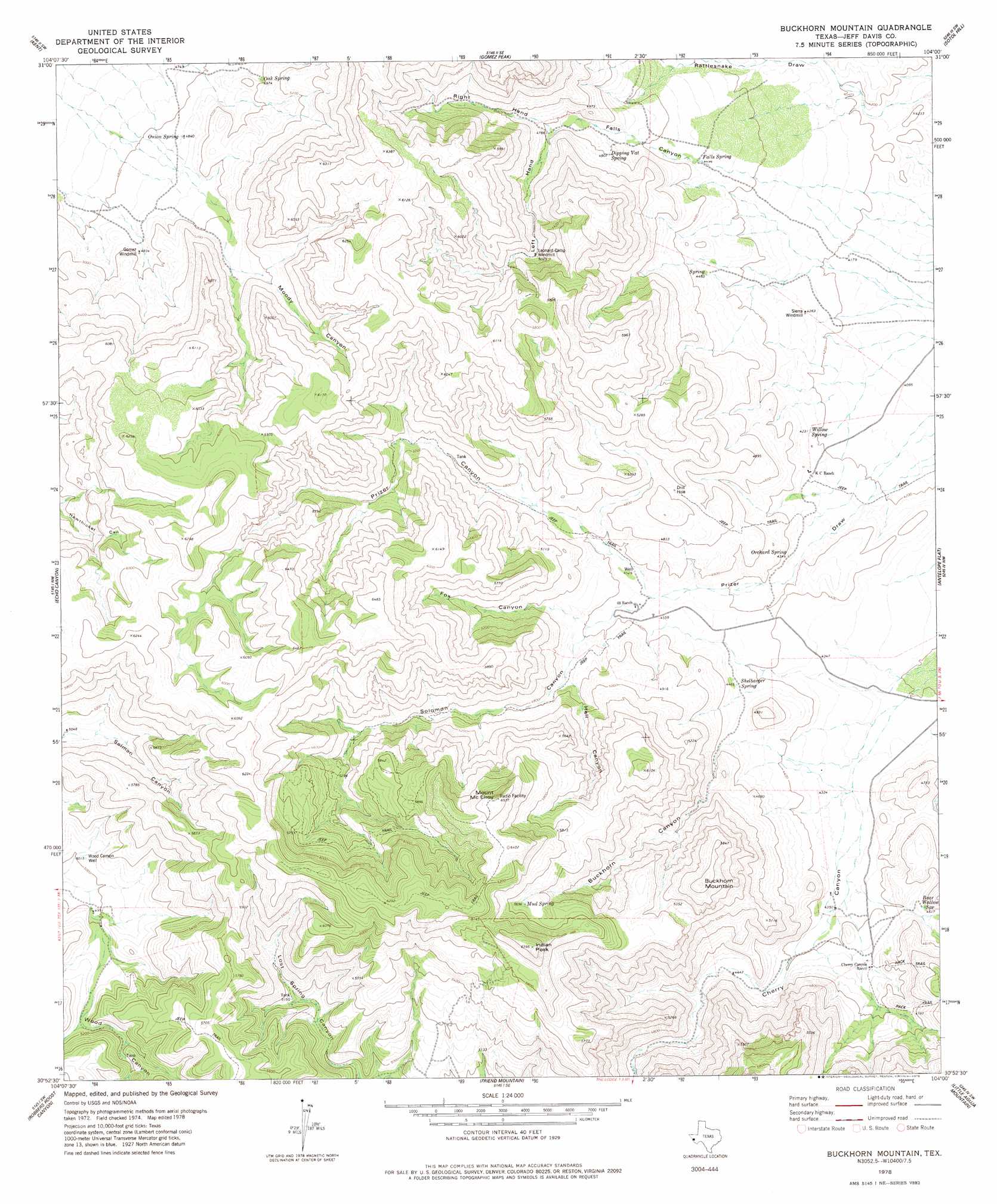
USGS Topo Quad 30104h1 - 1:24,000 scale
| Topo Map Name: | Buckhorn Mountain |
| USGS Topo Quad ID: | 30104h1 |
| Print Size: | ca. 21 1/4" wide x 27" high |
| Southeast Coordinates: | 30.875° N latitude / 104° W longitude |
| Map Center Coordinates: | 30.9375° N latitude / 104.0625° W longitude |
| U.S. State: | TX |
| Filename: | o30104h1.jpg |
| Download Map JPG Image: | Buckhorn Mountain topo map 1:24,000 scale |
| Map Type: | Topographic |
| Topo Series: | 7.5´ |
| Map Scale: | 1:24,000 |
| Source of Map Images: | United States Geological Survey (USGS) |
| Alternate Map Versions: |
Buckhorn Mountain TX 1978, updated 1978 Download PDF Buy paper map Buckhorn Mountain TX 2010 Download PDF Buy paper map Buckhorn Mountain TX 2012 Download PDF Buy paper map Buckhorn Mountain TX 2016 Download PDF Buy paper map |
1:24,000 Topo Quads surrounding Buckhorn Mountain
Panther Canyon |
Iron Mountain |
San Martine |
Gozar |
Florenzo Hill |
Fencepost Draw |
Kent |
Gomez Peak |
Sotol Hill |
Meier Hills |
Herds Pass |
Echo Canyon |
Buckhorn Mountain |
Antelope Flat |
Toyahvale |
Bare Mountain |
Robbers Roost Canyon |
Friend Mountain |
Little Aguja Mountain |
Big Aguja Mountain |
El Muerto Peak |
Mount Livermore |
Mount Locke |
Casket Mountain |
Swayback Mountain |
> Back to 30104e1 at 1:100,000 scale
> Back to 30104a1 at 1:250,000 scale
> Back to U.S. Topo Maps home
Buckhorn Mountain topo map: Gazetteer
Buckhorn Mountain: Springs
Bear Wallow Spring elevation 1373m 4504′Dipping Vat Spring elevation 1463m 4799′
Falls Spring elevation 1370m 4494′
Mud Spring elevation 1741m 5711′
Oak Spring elevation 1526m 5006′
Onion Spring elevation 1475m 4839′
Orchard Spring elevation 1321m 4333′
Shelbarger Spring elevation 1360m 4461′
Willow Spring elevation 1288m 4225′
Buckhorn Mountain: Summits
Buckhorn Mountain elevation 1807m 5928′Indian Peak elevation 1943m 6374′
Mount McElroy elevation 1992m 6535′
Buckhorn Mountain: Valleys
Buckhorn Canyon elevation 1384m 4540′Falls Canyon elevation 1378m 4520′
Fox Canyon elevation 1437m 4714′
Hell Canyon elevation 1447m 4747′
Left Hand Falls Canyon elevation 1456m 4776′
Moody Canyon elevation 1584m 5196′
Prizer Draw elevation 1248m 4094′
Right Hand Falls Canyon elevation 1456m 4776′
Solomon Canyon elevation 1411m 4629′
Willow Canyon elevation 1509m 4950′
Buckhorn Mountain: Wells
Wood Canyon Well elevation 1529m 5016′Buckhorn Mountain digital topo map on disk
Buy this Buckhorn Mountain topo map showing relief, roads, GPS coordinates and other geographical features, as a high-resolution digital map file on DVD: