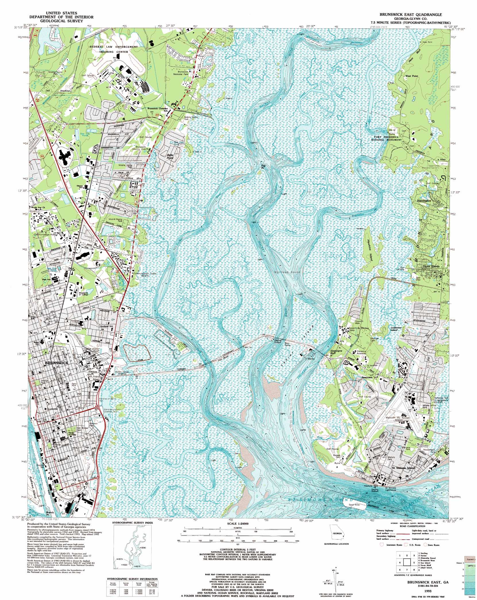
Brunswick East Topo Map Georgia
To zoom in, hover over the map of Brunswick East
USGS Topo Quad 31081b4 - 1:24,000 scale
| Topo Map Name: | Brunswick East |
| USGS Topo Quad ID: | 31081b4 |
| Print Size: | ca. 21 1/4" wide x 27" high |
| Southeast Coordinates: | 31.125° N latitude / 81.375° W longitude |
| Map Center Coordinates: | 31.1875° N latitude / 81.4375° W longitude |
| U.S. State: | GA |
| Filename: | o31081b4.jpg |
| Download Map JPG Image: | Brunswick East topo map 1:24,000 scale |
| Map Type: | Topographic |
| Topo Series: | 7.5´ |
| Map Scale: | 1:24,000 |
| Source of Map Images: | United States Geological Survey (USGS) |
| Alternate Map Versions: |
Brunswick East GA 1956, updated 1959 Download PDF Buy paper map Brunswick East GA 1979, updated 1980 Download PDF Buy paper map Brunswick East GA 1979, updated 1987 Download PDF Buy paper map Brunswick East GA 1979, updated 1988 Download PDF Buy paper map Brunswick East GA 1993, updated 1995 Download PDF Buy paper map Brunswick East GA 2011 Download PDF Buy paper map Brunswick East GA 2014 Download PDF Buy paper map |
1:24,000 Topo Quads surrounding Brunswick East
Everett |
Cox |
Ridgeville |
Doboy Sound |
Cabretta Inlet |
Thalmann |
Sterling |
Darien |
Altamaha Sound |
|
Bladen |
Brunswick West |
Brunswick East |
Sea Island |
|
Waverly |
Dover Bluff |
Jekyll Island |
||
Woodbine |
Kingsland Ne |
Cumberland Island North |
> Back to 31081a1 at 1:100,000 scale
> Back to 31080a1 at 1:250,000 scale
> Back to U.S. Topo Maps home
Brunswick East topo map: Gazetteer
Brunswick East: Airports
Malcolm McKinnon Airport elevation 4m 13′Brunswick East: Bays
Manhead Sound elevation 0m 0′Oglethorpe Bay elevation 0m 0′
Saint Simons Sound elevation 0m 0′
Brunswick East: Capes
Belle Point elevation 3m 9′Brandy Point elevation 0m 0′
Fog Point elevation 0m 0′
West Point elevation 1m 3′
Brunswick East: Channels
Clubbs Creek elevation 0m 0′Jove Creek elevation 0m 0′
Plantation Creek elevation 0m 0′
Terry Creek elevation 0m 0′
Brunswick East: Cliffs
Gascoigne Bluff elevation 3m 9′Pikes Bluff elevation 2m 6′
Brunswick East: Guts
Frederica River elevation 0m 0′Little River elevation 0m 0′
Brunswick East: Islands
Hawkins Island elevation 2m 6′Lanier Island elevation 1m 3′
Ledbetter Island elevation 3m 9′
Brunswick East: Parks
Altama Park elevation 5m 16′Bloody Marsh Site elevation 1m 3′
Brunswick Old Town Historic District elevation 2m 6′
Butler Field Park elevation 3m 9′
Butter Field Park elevation 3m 9′
Coffin Park elevation 1m 3′
Demere Park elevation 3m 9′
Dixville Park elevation 3m 9′
Epworth Park elevation 4m 13′
Fort Frederica National Monument elevation 3m 9′
Gateway Park elevation 2m 6′
Goodyear Park elevation 4m 13′
Halifax Square elevation 3m 9′
Hanover Park elevation 3m 9′
Hillsboro Square elevation 3m 9′
Kaiser Park elevation 4m 13′
Kay Square elevation 3m 9′
Madge Merritt Park elevation 4m 13′
Marshes of Glynn Overlook Park elevation 1m 3′
Marshes of Glynn Park elevation 1m 3′
Massingale Park elevation 3m 9′
Miller Park elevation 1m 3′
Neptune Park elevation 0m 0′
Orange Park elevation 3m 9′
Palmetto Park elevation 3m 9′
Paula Park elevation 4m 13′
Saint Marks Square elevation 3m 9′
Twitty Park elevation 4m 13′
Urbana Park elevation 3m 9′
Windsor Park elevation 2m 6′
Windsor Park elevation 2m 6′
Brunswick East: Populated Places
Azalea Gardens elevation 2m 6′Back Landing elevation 3m 9′
Bel Air elevation 4m 13′
Belle Point Estates elevation 4m 13′
Beverly Shores elevation 4m 13′
Blackbanks elevation 4m 13′
Brunswick elevation 3m 9′
Brunswick Villa elevation 4m 13′
Cabana Court Mobile Home Park elevation 3m 9′
Central Park elevation 2m 6′
College Park elevation 4m 13′
Country Club Estates elevation 1m 3′
Country Club Park elevation 5m 16′
Cypress Mills elevation 2m 6′
Demere Hammock elevation 1m 3′
Demere Park elevation 3m 9′
Devenwood elevation 3m 9′
Druid Oaks elevation 3m 9′
Druid Oaks Mobile Home Park elevation 2m 6′
East End elevation 3m 9′
Ebo Landing elevation 1m 3′
El Dorado elevation 2m 6′
Epworth Acres elevation 4m 13′
Fairway Oaks elevation 4m 13′
Glynco Annex elevation 6m 19′
Glynn Haven elevation 4m 13′
Glynnvilla elevation 3m 9′
Golf Retreat elevation 3m 9′
Gordon Oaks Homes elevation 3m 9′
Island Retreat elevation 3m 9′
Island View elevation 1m 3′
Jewtown elevation 4m 13′
Kelvin Grove elevation 3m 9′
Kensington Park elevation 6m 19′
King City elevation 1m 3′
Kings Terrace elevation 4m 13′
Kinstle elevation 5m 16′
Magnolia Park elevation 4m 13′
Mallory Park elevation 4m 13′
McIntyre Court elevation 3m 9′
Oglethorpe Park elevation 3m 9′
Pine Forest elevation 6m 19′
Pineview elevation 6m 19′
Riverside elevation 1m 3′
Riverview elevation 3m 9′
Saint Clair Estates elevation 5m 16′
Saint Simon Mills elevation 3m 9′
Saint Simons elevation 3m 9′
Saint Simons Heights elevation 5m 16′
Silver Lake elevation 5m 16′
Suburban Estates elevation 4m 13′
The Meadows elevation 2m 6′
Thornhill Mobile Home Park elevation 3m 9′
Transvilla Mobile Home Park elevation 3m 9′
Waverly Pines Park elevation 7m 22′
Wesley Oaks elevation 2m 6′
Windward Acres elevation 4m 13′
Wymberly-On-The-Marsh elevation 4m 13′
Youngwood elevation 2m 6′
Brunswick East: Post Offices
Brunswick Post Office elevation 3m 9′Brunswick East: Streams
Back River elevation 0m 0′Belle Point Creek elevation 0m 0′
Cedar Point Creek elevation 0m 0′
Crooked Creek elevation 0m 0′
Cypress Mill Creek elevation 0m 0′
Dunbar Creek elevation 1m 3′
Dupree Creek elevation 0m 0′
Grant Creek elevation 0m 0′
Hawkins Creek elevation 0m 0′
Hog Crawl Creek elevation 1m 3′
King Creek elevation 0m 0′
Mackay River elevation 0m 0′
Troup Creek elevation 0m 0′
Brunswick East: Swamps
Marshes of Glynn elevation 0m 0′Brunswick East digital topo map on disk
Buy this Brunswick East topo map showing relief, roads, GPS coordinates and other geographical features, as a high-resolution digital map file on DVD: