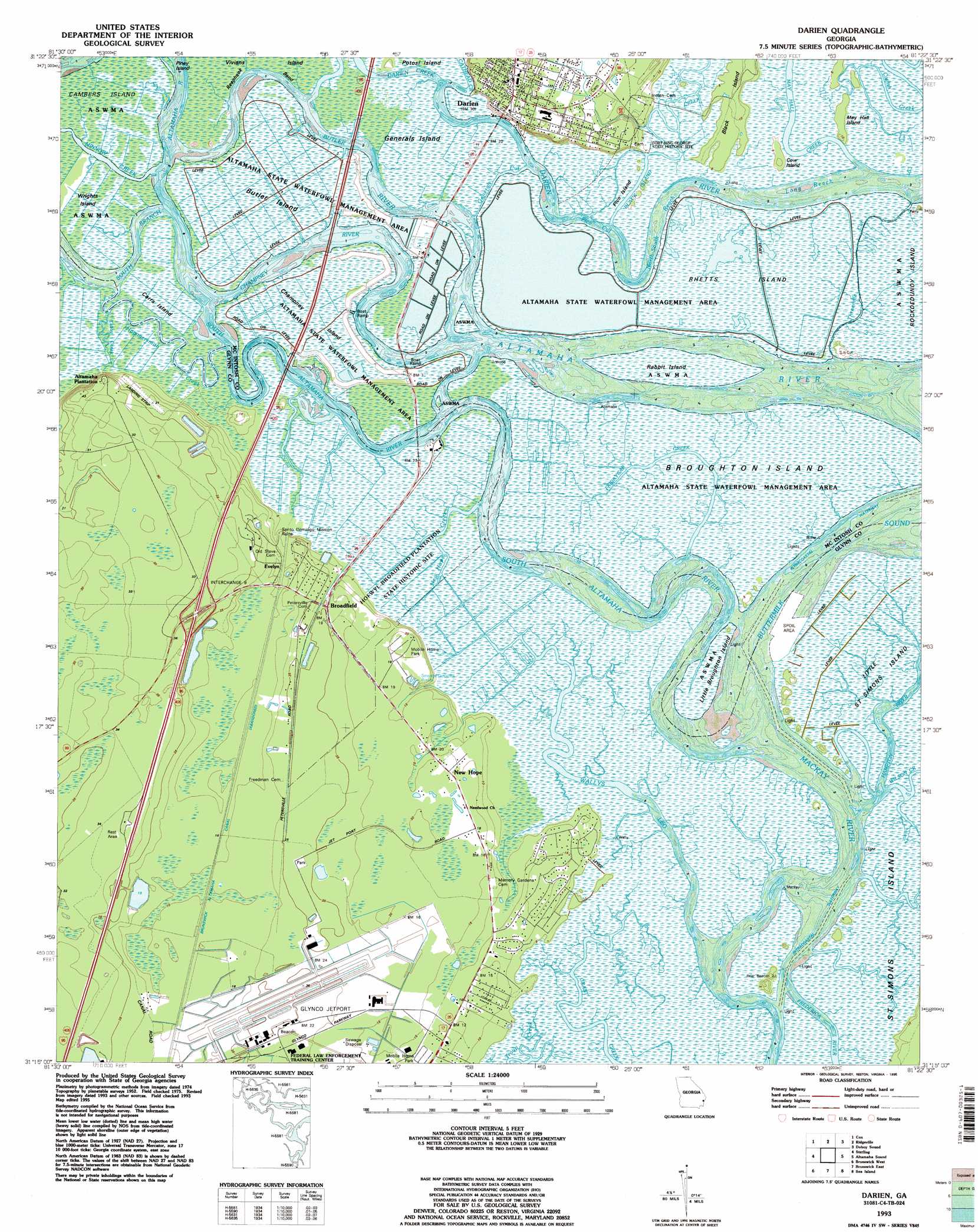
Darien Topo Map Georgia
To zoom in, hover over the map of Darien
USGS Topo Quad 31081c4 - 1:24,000 scale
| Topo Map Name: | Darien |
| USGS Topo Quad ID: | 31081c4 |
| Print Size: | ca. 21 1/4" wide x 27" high |
| Southeast Coordinates: | 31.25° N latitude / 81.375° W longitude |
| Map Center Coordinates: | 31.3125° N latitude / 81.4375° W longitude |
| U.S. State: | GA |
| Filename: | o31081c4.jpg |
| Download Map JPG Image: | Darien topo map 1:24,000 scale |
| Map Type: | Topographic |
| Topo Series: | 7.5´ |
| Map Scale: | 1:24,000 |
| Source of Map Images: | United States Geological Survey (USGS) |
| Alternate Map Versions: |
Darien GA 1956, updated 1959 Download PDF Buy paper map Darien GA 1956, updated 1964 Download PDF Buy paper map Darien GA 1979, updated 1979 Download PDF Buy paper map Darien GA 1993, updated 1995 Download PDF Buy paper map Darien GA 2011 Download PDF Buy paper map Darien GA 2014 Download PDF Buy paper map |
1:24,000 Topo Quads surrounding Darien
Bug Island |
Townsend |
Eulonia |
Shellman Bluff |
Sapelo Sound |
Everett |
Cox |
Ridgeville |
Doboy Sound |
Cabretta Inlet |
Thalmann |
Sterling |
Darien |
Altamaha Sound |
|
Bladen |
Brunswick West |
Brunswick East |
Sea Island |
|
Waverly |
Dover Bluff |
Jekyll Island |
> Back to 31081a1 at 1:100,000 scale
> Back to 31080a1 at 1:250,000 scale
> Back to U.S. Topo Maps home
Darien topo map: Gazetteer
Darien: Airports
Glynco Jetport Airport elevation 8m 26′Darien: Bays
Buttermilk Sound elevation 0m 0′Darien: Bends
Pico Cut elevation 0m 0′Reaphook Bend elevation 1m 3′
Darien: Canals
Brunswick-Altamaha Canal elevation 4m 13′Darien: Channels
Butler River elevation 0m 0′Catfish Creek elevation 0m 0′
Champney River elevation 0m 0′
Hammersmith Creek elevation 1m 3′
Intracoastal Waterway elevation 0m 0′
Long Reach elevation 0m 0′
North-South Reach elevation 0m 0′
Threemile Cut elevation 1m 3′
Wallys Leg elevation 0m 0′
Wood Cut elevation 0m 0′
Darien: Crossings
Exit 9 elevation 14m 45′Darien: Guts
Black Island Creek elevation 1m 3′Generals Cut elevation 0m 0′
May Hall Creek elevation 0m 0′
Darien: Islands
Black Island elevation 2m 6′Broughton Island elevation 0m 0′
Butler Island elevation 0m 0′
Cambers Island elevation 0m 0′
Carrs Island elevation 1m 3′
Champney Island elevation 1m 3′
Eagle Island elevation 3m 9′
Generals Island elevation 0m 0′
Little Broughton Island elevation 0m 0′
May Hall Island elevation 1m 3′
Pico Island elevation 1m 3′
Piney Island elevation 0m 0′
Rabbit Island elevation 0m 0′
Rhetts Island elevation 1m 3′
Darien: Parks
Columbus Square elevation 9m 29′Fort King George State Historic Site elevation 1m 3′
Jefferson Square (historical) elevation 6m 19′
Oglethorpe Square elevation 9m 29′
Vernon Square elevation 9m 29′
Vernon Square-Columbus Square Historic District elevation 9m 29′
Darien: Populated Places
Bel-Air elevation 6m 19′Boys Estate elevation 8m 26′
Broadfield elevation 6m 19′
Darien elevation 9m 29′
Evelyn elevation 8m 26′
Marshes-of-Mackay elevation 4m 13′
New Hope elevation 5m 16′
New Hope Mobile Home Park elevation 4m 13′
North End elevation 4m 13′
Oglethorpe Manor elevation 3m 9′
Darien: Post Offices
Darien Post Office elevation 8m 26′Darien: Streams
Cathead Creek elevation 0m 0′Darien Creek elevation 0m 0′
Fridaycap Creek elevation 0m 0′
New Hope Creek elevation 0m 0′
South Altamaha River elevation 0m 0′
Wilson Creek elevation 0m 0′
Darien digital topo map on disk
Buy this Darien topo map showing relief, roads, GPS coordinates and other geographical features, as a high-resolution digital map file on DVD: