Doboy Sound Topo Map Georgia
To zoom in, hover over the map of Doboy Sound
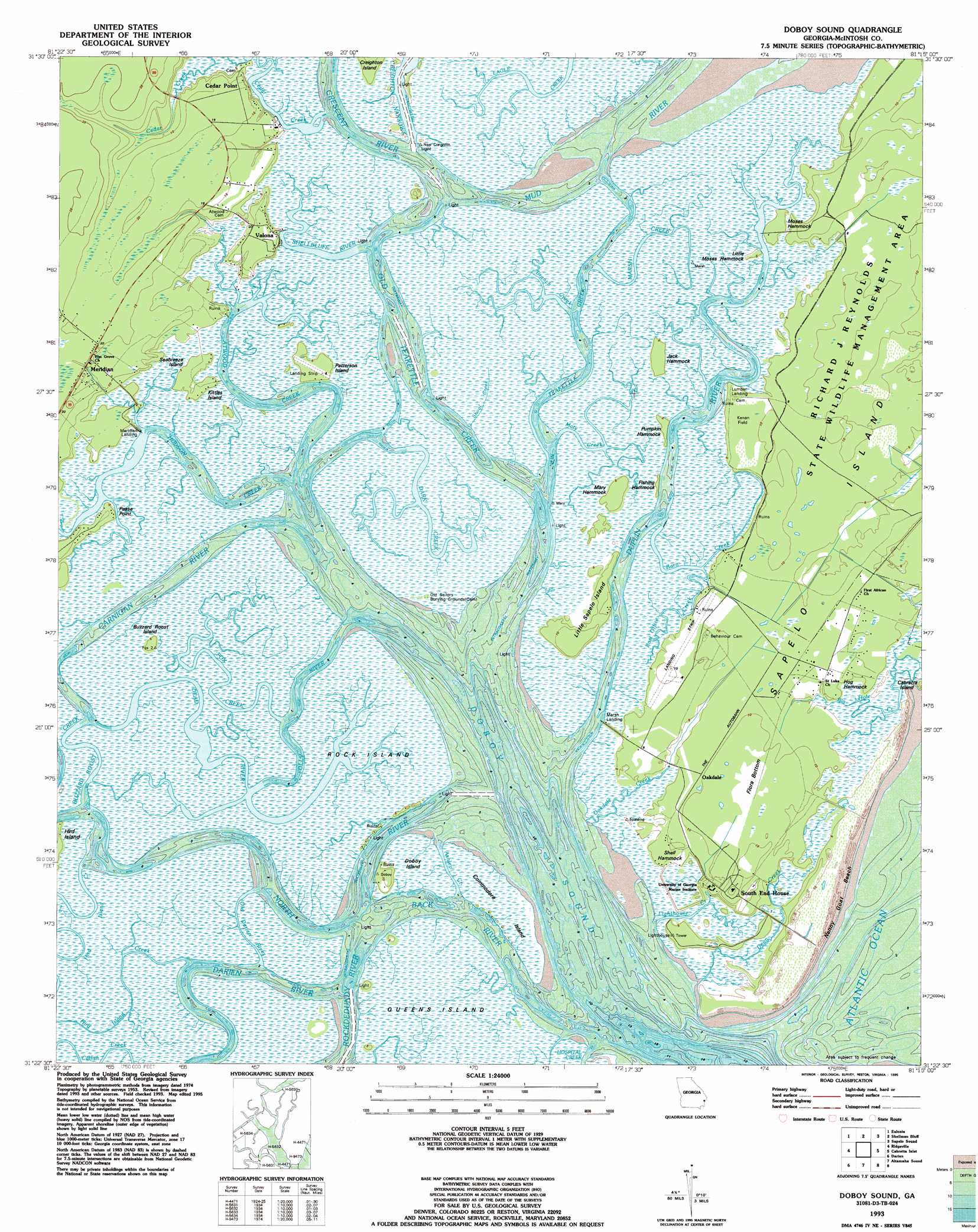
USGS Topo Quad 31081d3 - 1:24,000 scale
| Topo Map Name: | Doboy Sound |
| USGS Topo Quad ID: | 31081d3 |
| Print Size: | ca. 21 1/4" wide x 27" high |
| Southeast Coordinates: | 31.375° N latitude / 81.25° W longitude |
| Map Center Coordinates: | 31.4375° N latitude / 81.3125° W longitude |
| U.S. State: | GA |
| Filename: | o31081d3.jpg |
| Download Map JPG Image: | Doboy Sound topo map 1:24,000 scale |
| Map Type: | Topographic |
| Topo Series: | 7.5´ |
| Map Scale: | 1:24,000 |
| Source of Map Images: | United States Geological Survey (USGS) |
| Alternate Map Versions: |
Doboy Sound GA 1954, updated 1959 Download PDF Buy paper map Doboy Sound GA 1954, updated 1974 Download PDF Buy paper map Doboy Sound GA 1979, updated 1979 Download PDF Buy paper map Doboy Sound GA 1979, updated 1979 Download PDF Buy paper map Doboy Sound GA 1993, updated 1995 Download PDF Buy paper map Doboy Sound GA 2011 Download PDF Buy paper map Doboy Sound GA 2014 Download PDF Buy paper map |
1:24,000 Topo Quads surrounding Doboy Sound
East Of Ludowici |
Riceboro |
Seabrook |
Saint Catherines Sound |
|
Townsend |
Eulonia |
Shellman Bluff |
Sapelo Sound |
|
Cox |
Ridgeville |
Doboy Sound |
Cabretta Inlet |
|
Sterling |
Darien |
Altamaha Sound |
||
Brunswick West |
Brunswick East |
Sea Island |
> Back to 31081a1 at 1:100,000 scale
> Back to 31080a1 at 1:250,000 scale
> Back to U.S. Topo Maps home
Doboy Sound topo map: Gazetteer
Doboy Sound: Airports
Patterson Island Airport elevation 1m 3′Sapelo Island Airport elevation 2m 6′
Doboy Sound: Bays
Doboy Sound elevation 0m 0′Doboy Sound: Beaches
Nanny Goat Beach elevation 2m 6′Doboy Sound: Capes
Pease Point elevation 1m 3′Doboy Sound: Channels
Back River elevation 0m 0′Barn Creek elevation 1m 3′
Carnigan River elevation 0m 0′
Creighton Narrows elevation 0m 0′
New Teakettle Creek elevation 1m 3′
North River elevation 0m 0′
Old Darien River elevation 0m 0′
Old Teakettle Creek elevation 0m 0′
Shellbluff River elevation 0m 0′
Doboy Sound: Flats
Flora Bottom elevation 3m 9′Kenan Field elevation 2m 6′
Doboy Sound: Guts
Ashley Creek elevation 0m 0′Buzzard Roost Creek elevation 0m 0′
Dead River elevation 1m 3′
Folly River elevation 3m 9′
Post Office Creek elevation 1m 3′
Shoal Creek elevation 0m 0′
Doboy Sound: Islands
Buzzard Roost Island elevation 1m 3′Commodore Island elevation 1m 3′
Doboy Island elevation 1m 3′
Fishing Hammock elevation 1m 3′
Hog Hammock elevation 1m 3′
Jack Hammock elevation 1m 3′
Little Moses Hammock elevation 1m 3′
Little Sapelo Island elevation 4m 13′
Mary Hammock elevation 1m 3′
Moses Hammock elevation 1m 3′
Patterson Island elevation 1m 3′
Pumpkin Hammock elevation 1m 3′
Queens Island elevation 0m 0′
Rock Island elevation 1m 3′
Doboy Sound: Parks
Richard J Reynolds State Wildlife Refuge elevation 3m 9′Sapelo Island National Estuarine Sanctuary elevation 1m 3′
Doboy Sound: Populated Places
Cedar Point elevation 4m 13′Doboy (historical) elevation 2m 6′
Sapelo Island elevation 3m 9′
Valona elevation 4m 13′
Doboy Sound: Streams
Atwood Creek elevation 0m 0′Branch Creek elevation 0m 0′
Cedar Creek elevation 0m 0′
Crescent River elevation 0m 0′
Dark Creek elevation 1m 3′
Dean Creek elevation 0m 0′
Duplin River elevation 0m 0′
Fox Creek elevation 0m 0′
Hudson Creek elevation 0m 0′
Lighthouse Creek elevation 0m 0′
Marsh Creek elevation 1m 3′
Mary Creek elevation 1m 3′
Doboy Sound digital topo map on disk
Buy this Doboy Sound topo map showing relief, roads, GPS coordinates and other geographical features, as a high-resolution digital map file on DVD: