Cox Topo Map Georgia
To zoom in, hover over the map of Cox
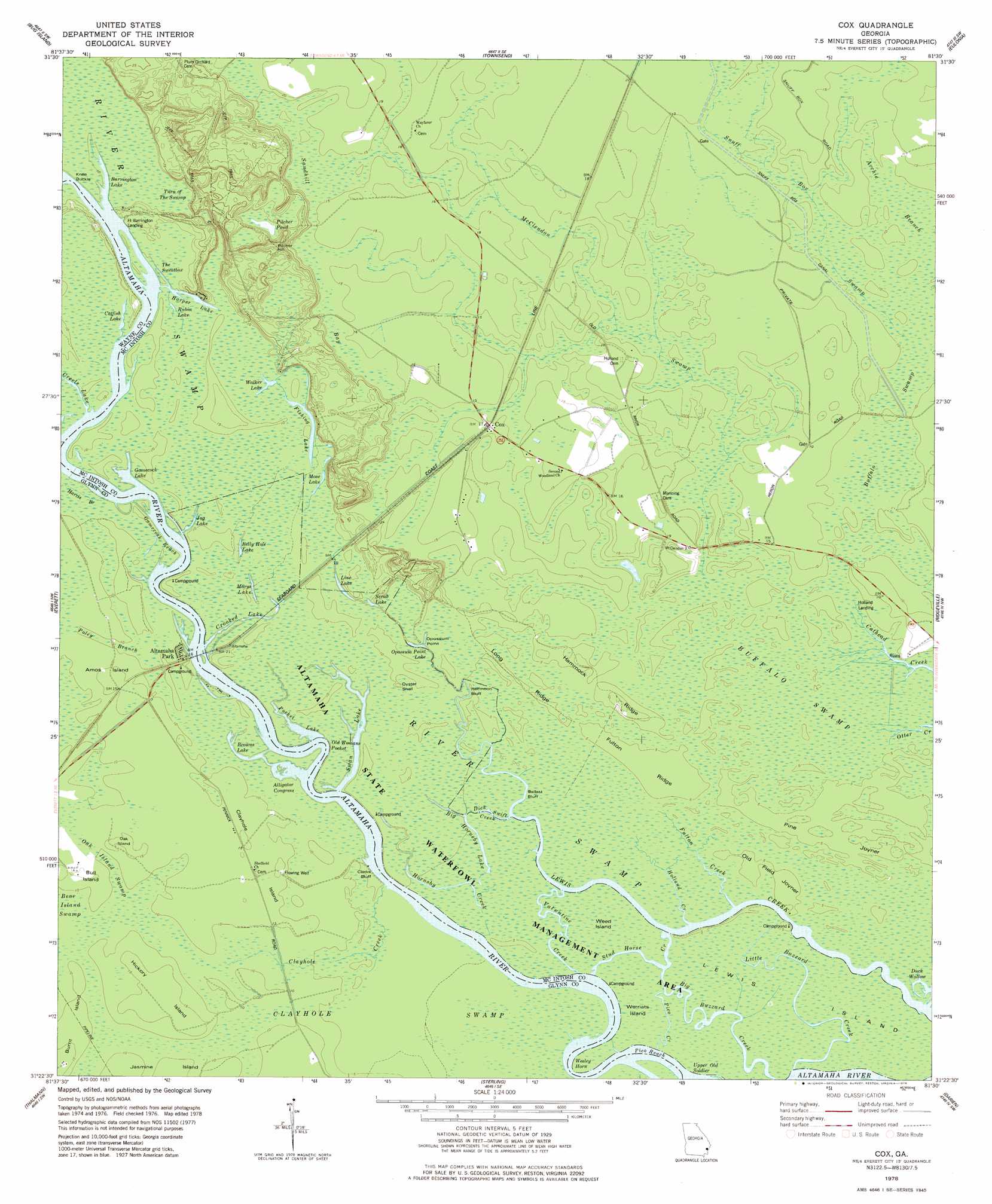
USGS Topo Quad 31081d5 - 1:24,000 scale
| Topo Map Name: | Cox |
| USGS Topo Quad ID: | 31081d5 |
| Print Size: | ca. 21 1/4" wide x 27" high |
| Southeast Coordinates: | 31.375° N latitude / 81.5° W longitude |
| Map Center Coordinates: | 31.4375° N latitude / 81.5625° W longitude |
| U.S. State: | GA |
| Filename: | o31081d5.jpg |
| Download Map JPG Image: | Cox topo map 1:24,000 scale |
| Map Type: | Topographic |
| Topo Series: | 7.5´ |
| Map Scale: | 1:24,000 |
| Source of Map Images: | United States Geological Survey (USGS) |
| Alternate Map Versions: |
Cox GA 1978, updated 1978 Download PDF Buy paper map Cox GA 2011 Download PDF Buy paper map Cox GA 2014 Download PDF Buy paper map |
1:24,000 Topo Quads surrounding Cox
Doctortown |
Ludowici |
East Of Ludowici |
Riceboro |
Seabrook |
Jesup East |
Bug Island |
Townsend |
Eulonia |
Shellman Bluff |
Manningtown |
Everett |
Cox |
Ridgeville |
Doboy Sound |
Browntown |
Thalmann |
Sterling |
Darien |
Altamaha Sound |
Waynesville |
Bladen |
Brunswick West |
Brunswick East |
Sea Island |
> Back to 31081a1 at 1:100,000 scale
> Back to 31080a1 at 1:250,000 scale
> Back to U.S. Topo Maps home
Cox topo map: Gazetteer
Cox: Areas
The Sweatbox elevation 3m 9′Turn of the Swamp elevation 4m 13′
Cox: Bends
Knee Buckle elevation 3m 9′Old Womans Pocket elevation 0m 0′
Wesley Horn elevation 0m 0′
Cox: Capes
Opossum Point elevation 1m 3′Cox: Channels
Gamecock Reach elevation 1m 3′Pico Reach elevation 0m 0′
Cox: Cliffs
Ballast Bluff elevation 1m 3′Clarks Bluff elevation 1m 3′
Halfmoon Bluff elevation 1m 3′
Cox: Crossings
Fort Barrington Ferry (historical) elevation 2m 6′Cox: Flats
Old Field Joyner elevation 1m 3′Pine Joyner elevation 1m 3′
Cox: Guts
Little Buzzard Creek elevation 1m 3′Pico Creek elevation 1m 3′
Stud Horse Creek elevation 0m 0′
Valentine Creek elevation 1m 3′
Cox: Islands
Amos Island elevation 5m 16′Bull Island elevation 3m 9′
Burnt Island elevation 4m 13′
Clayhole Island elevation 4m 13′
Hickory Island elevation 5m 16′
Lewis Island elevation 1m 3′
Oak Island elevation 4m 13′
Weed Island elevation 1m 3′
Werriats Island elevation 1m 3′
Cox: Lakes
Alligator Congress elevation 0m 0′Barrington Lake elevation 2m 6′
Belly Hole Lake elevation 3m 9′
Big Hornsby Lake elevation 1m 3′
Browns Lake elevation 0m 0′
Catfish Lake elevation 3m 9′
Crooked Lake elevation 1m 3′
Duck Wallow elevation 1m 3′
Fishing Lake elevation 3m 9′
Gamecock Lake elevation 1m 3′
Harper Lake elevation 3m 9′
Jug Lake elevation 1m 3′
Line Lake elevation 1m 3′
Marys Lake elevation 1m 3′
Mose Lake elevation 3m 9′
Opossum Point Lake elevation 1m 3′
Pilcher Pond elevation 8m 26′
Pocket Lake elevation 0m 0′
Rubin Lake elevation 3m 9′
Scrub Lake elevation 1m 3′
Walker Lake elevation 2m 6′
Cox: Populated Places
Altamaha Park elevation 4m 13′Cox elevation 4m 13′
Cox: Ridges
Fulton Ridge elevation 1m 3′Hammock Ridge elevation 1m 3′
Long Ridge elevation 1m 3′
Cox: Streams
Big Buzzard Creek elevation 1m 3′Buffalo Creek elevation 1m 3′
Clayhole Creek elevation 1m 3′
Dick Swift Creek elevation 1m 3′
Fulton Creek elevation 0m 0′
Harris Branch elevation 1m 3′
Holland Creek elevation 0m 0′
Hornsby Creek elevation 1m 3′
McClendon Creek elevation 1m 3′
Poley Branch elevation 2m 6′
Cox: Summits
Oyster Shell elevation 5m 16′Pilcher Hill elevation 20m 65′
Cox: Swamps
Archie Branch elevation 3m 9′Buffalo Swamp elevation 3m 9′
McClendon Swamp elevation 0m 0′
Oak Island Swamp elevation 3m 9′
Sandhill Bay elevation 4m 13′
Snuff Box Swamp elevation 3m 9′
Upper Old Soldier elevation 1m 3′
Cox digital topo map on disk
Buy this Cox topo map showing relief, roads, GPS coordinates and other geographical features, as a high-resolution digital map file on DVD: