Saint Catherines Sound Topo Map Georgia
To zoom in, hover over the map of Saint Catherines Sound
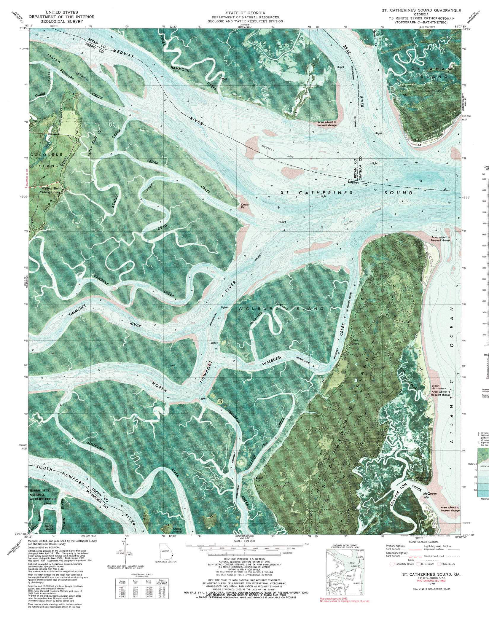
USGS Topo Quad 31081f2 - 1:24,000 scale
| Topo Map Name: | Saint Catherines Sound |
| USGS Topo Quad ID: | 31081f2 |
| Print Size: | ca. 21 1/4" wide x 27" high |
| Southeast Coordinates: | 31.625° N latitude / 81.125° W longitude |
| Map Center Coordinates: | 31.6875° N latitude / 81.1875° W longitude |
| U.S. State: | GA |
| Filename: | p31081f2.jpg |
| Download Map JPG Image: | Saint Catherines Sound topo map 1:24,000 scale |
| Map Type: | Orthophoto |
| Topo Series: | 7.5´ |
| Map Scale: | 1:24,000 |
| Source of Map Images: | United States Geological Survey (USGS) |
| Alternate Map Versions: |
St Catherines Sound GA 1954, updated 1958 Download PDF Buy paper map St Catherines Sound GA 1954, updated 1970 Download PDF Buy paper map St Catherines Sound GA 1979, updated 1980 Download PDF Buy paper map St Catherines Sound GA 1979, updated 1980 Download PDF Buy paper map Saint Catherines Sound GA 2011 Download PDF Buy paper map Saint Catherines Sound GA 2014 Download PDF Buy paper map |
1:24,000 Topo Quads surrounding Saint Catherines Sound
Limerick Nw |
Richmond Hill |
Burroughs |
Isle Of Hope |
Wassaw Sound |
Dorchester |
Limerick Se |
Oak Level |
Raccoon Key |
|
Riceboro |
Seabrook |
Saint Catherines Sound |
||
Eulonia |
Shellman Bluff |
Sapelo Sound |
||
Ridgeville |
Doboy Sound |
Cabretta Inlet |
> Back to 31081e1 at 1:100,000 scale
> Back to 31080a1 at 1:250,000 scale
> Back to U.S. Topo Maps home
Saint Catherines Sound topo map: Gazetteer
Saint Catherines Sound: Airports
Youmans Landing Airfield elevation 4m 13′Saint Catherines Sound: Bars
Medway Spit elevation 0m 0′Middle Ground elevation 0m 0′
Saint Catherines Sound: Bays
McQueen Inlet elevation 0m 0′Saint Catherines Sound elevation 0m 0′
Saint Catherines Sound: Capes
Cedar Point elevation 1m 3′Saint Catherines Sound: Channels
Timmons River elevation 0m 0′Walburg Creek elevation 0m 0′
Saint Catherines Sound: Cliffs
Yellow Bluff elevation 4m 13′Saint Catherines Sound: Islands
Black Hammock elevation 0m 0′McQueen Hammock elevation 0m 0′
Moss Island elevation 1m 3′
Saint Catherines Island elevation 4m 13′
Walburg Island elevation 1m 3′
Saint Catherines Sound: Streams
Ashley Creek elevation 0m 0′Bear River elevation 0m 0′
Cattle Pen Creek elevation 0m 0′
Cedar Creek elevation 0m 0′
Dead Creek elevation 0m 0′
Gould Creek elevation 0m 0′
Jacobs Creek elevation 0m 0′
Jones Hammock Creek elevation 1m 3′
Medway River elevation 0m 0′
Necessary Creek elevation 0m 0′
Newell Creek elevation 0m 0′
North Newport River elevation 0m 0′
Sunbury Creek elevation 0m 0′
Vandyke Creek elevation 0m 0′
Yellow Bluff Creek elevation 1m 3′
Saint Catherines Sound digital topo map on disk
Buy this Saint Catherines Sound topo map showing relief, roads, GPS coordinates and other geographical features, as a high-resolution digital map file on DVD: