Oak Level Topo Map Georgia
To zoom in, hover over the map of Oak Level
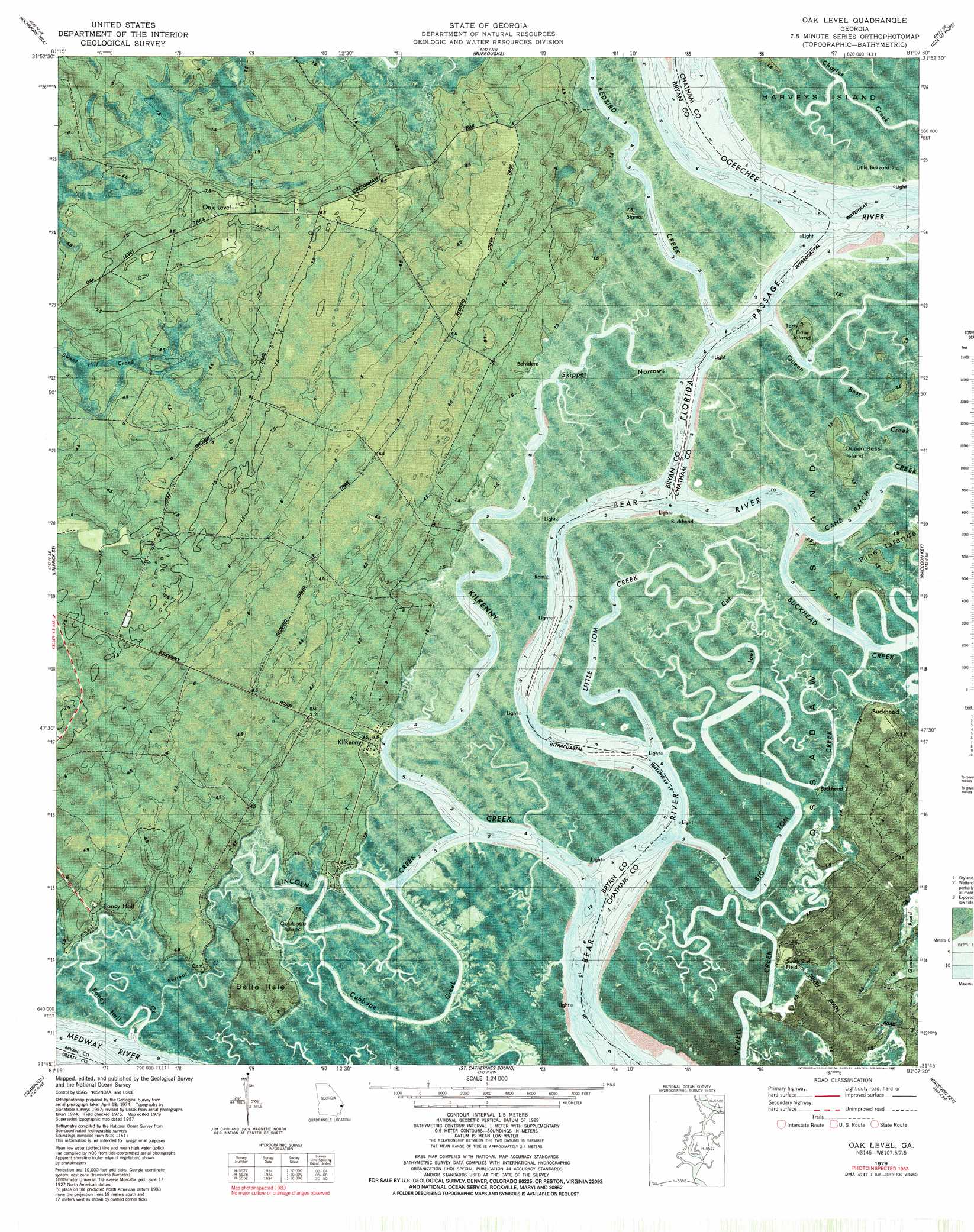
USGS Topo Quad 31081g2 - 1:24,000 scale
| Topo Map Name: | Oak Level |
| USGS Topo Quad ID: | 31081g2 |
| Print Size: | ca. 21 1/4" wide x 27" high |
| Southeast Coordinates: | 31.75° N latitude / 81.125° W longitude |
| Map Center Coordinates: | 31.8125° N latitude / 81.1875° W longitude |
| U.S. State: | GA |
| Filename: | p31081g2.jpg |
| Download Map JPG Image: | Oak Level topo map 1:24,000 scale |
| Map Type: | Orthophoto |
| Topo Series: | 7.5´ |
| Map Scale: | 1:24,000 |
| Source of Map Images: | United States Geological Survey (USGS) |
| Alternate Map Versions: |
Oak Level GA 1957, updated 1959 Download PDF Buy paper map Oak Level GA 1957, updated 1965 Download PDF Buy paper map Oak Level GA 1979, updated 1987 Download PDF Buy paper map Oak Level GA 1979, updated 1987 Download PDF Buy paper map Oak Level GA 2011 Download PDF Buy paper map Oak Level GA 2014 Download PDF Buy paper map |
1:24,000 Topo Quads surrounding Oak Level
Meldrim Sw |
Meldrim Se |
Garden City |
Savannah |
Fort Pulaski |
Limerick Nw |
Richmond Hill |
Burroughs |
Isle Of Hope |
Wassaw Sound |
Dorchester |
Limerick Se |
Oak Level |
Raccoon Key |
|
Riceboro |
Seabrook |
Saint Catherines Sound |
||
Eulonia |
Shellman Bluff |
Sapelo Sound |
> Back to 31081e1 at 1:100,000 scale
> Back to 31080a1 at 1:250,000 scale
> Back to U.S. Topo Maps home
Oak Level topo map: Gazetteer
Oak Level: Channels
Charles Creek elevation 0m 0′Florida Passage elevation 0m 0′
Skipper Narrows elevation 1m 3′
Oak Level: Cliffs
Kilkenny Bluff elevation 3m 9′Oak Level: Islands
Bear Island elevation 3m 9′Belle Isle elevation 3m 9′
Cubbage Island elevation 1m 3′
Pine Islands elevation 1m 3′
Queen Bess Island elevation 1m 3′
Oak Level: Parks
South End Field elevation 3m 9′Oak Level: Populated Places
Buckhead elevation 3m 9′Cottonham (historical) elevation 4m 13′
Fancy Hall elevation 4m 13′
Oak Level elevation 8m 26′
Sweet Hill elevation 7m 22′
Oak Level: Streams
Big Tom Creek elevation 0m 0′Buckhead Creek elevation 0m 0′
Cane Patch Creek elevation 0m 0′
Cubbage Creek elevation 0m 0′
Fancy Hall Creek elevation 0m 0′
Kilkenny Creek elevation 0m 0′
Lincoln Creek elevation 0m 0′
Little Tom Creek elevation 0m 0′
Queen Bess Creek elevation 0m 0′
Redbird Creek elevation 0m 0′
Retreat Creek elevation 0m 0′
Oak Level digital topo map on disk
Buy this Oak Level topo map showing relief, roads, GPS coordinates and other geographical features, as a high-resolution digital map file on DVD: