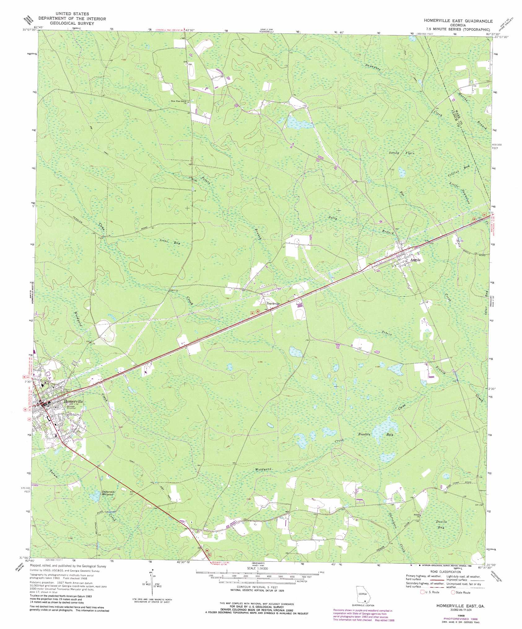
Homerville East Topo Map Georgia
To zoom in, hover over the map of Homerville East
USGS Topo Quad 31082a6 - 1:24,000 scale
| Topo Map Name: | Homerville East |
| USGS Topo Quad ID: | 31082a6 |
| Print Size: | ca. 21 1/4" wide x 27" high |
| Southeast Coordinates: | 31° N latitude / 82.625° W longitude |
| Map Center Coordinates: | 31.0625° N latitude / 82.6875° W longitude |
| U.S. State: | GA |
| Filename: | o31082a6.jpg |
| Download Map JPG Image: | Homerville East topo map 1:24,000 scale |
| Map Type: | Topographic |
| Topo Series: | 7.5´ |
| Map Scale: | 1:24,000 |
| Source of Map Images: | United States Geological Survey (USGS) |
| Alternate Map Versions: |
Homerville East GA 1968, updated 1969 Download PDF Buy paper map Homerville East GA 1968, updated 1970 Download PDF Buy paper map Homerville East GA 1968, updated 1988 Download PDF Buy paper map Homerville East GA 2011 Download PDF Buy paper map Homerville East GA 2014 Download PDF Buy paper map |
1:24,000 Topo Quads surrounding Homerville East
Kirkland |
Pearson |
Axson |
Talmo |
Dixie Union |
Henderson Still |
Sandy Bottom |
Cogdell |
Pine Valley |
Waycross West |
Sirmans |
Homerville West |
Homerville East |
Manor |
Waycross Sw |
Stockton |
Du Pont |
Midway |
Spooner |
Cravens Island |
Haylow |
Thelma |
Headlight |
Colon |
The Pocket |
> Back to 31082a1 at 1:100,000 scale
> Back to 31082a1 at 1:250,000 scale
> Back to U.S. Topo Maps home
Homerville East topo map: Gazetteer
Homerville East: Bays
Bunkle Bay elevation 47m 154′Homerville East: Flats
Sandy Flats elevation 49m 160′Homerville East: Populated Places
Argyle elevation 49m 160′Homerville elevation 54m 177′
Paletree elevation 52m 170′
Traisville elevation 50m 164′
Homerville East: Post Offices
Homerville Post Office elevation 54m 177′Homerville East: Reservoirs
Dickerson Millpond elevation 50m 164′Homerville East: Streams
Box Creek elevation 45m 147′Peters Branch elevation 46m 150′
Polly Branch elevation 48m 157′
Woodyard Creek elevation 48m 157′
Homerville East: Swamps
Collins Bay elevation 48m 157′Devils Bay elevation 47m 154′
Isiac Bay elevation 54m 177′
Homerville East digital topo map on disk
Buy this Homerville East topo map showing relief, roads, GPS coordinates and other geographical features, as a high-resolution digital map file on DVD: