Hoboken West Topo Map Georgia
To zoom in, hover over the map of Hoboken West
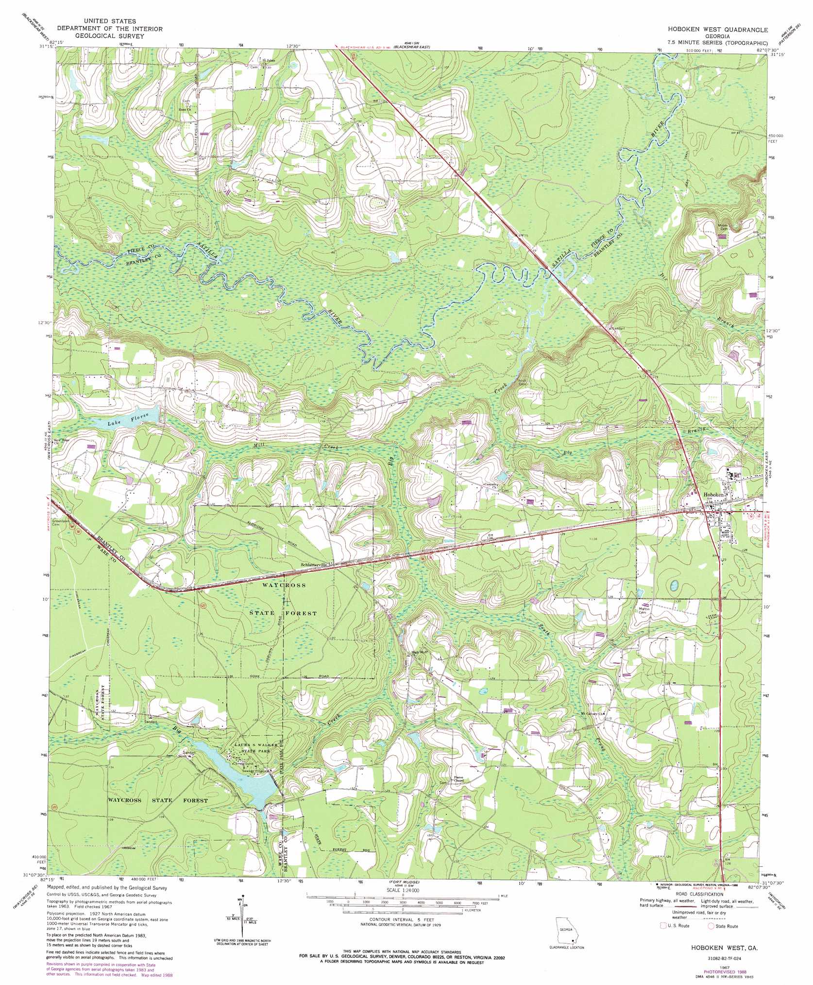
USGS Topo Quad 31082b2 - 1:24,000 scale
| Topo Map Name: | Hoboken West |
| USGS Topo Quad ID: | 31082b2 |
| Print Size: | ca. 21 1/4" wide x 27" high |
| Southeast Coordinates: | 31.125° N latitude / 82.125° W longitude |
| Map Center Coordinates: | 31.1875° N latitude / 82.1875° W longitude |
| U.S. State: | GA |
| Filename: | o31082b2.jpg |
| Download Map JPG Image: | Hoboken West topo map 1:24,000 scale |
| Map Type: | Topographic |
| Topo Series: | 7.5´ |
| Map Scale: | 1:24,000 |
| Source of Map Images: | United States Geological Survey (USGS) |
| Alternate Map Versions: |
Hoboken West GA 1967, updated 1969 Download PDF Buy paper map Hoboken West GA 1967, updated 1988 Download PDF Buy paper map Hoboken West GA 2011 Download PDF Buy paper map Hoboken West GA 2014 Download PDF Buy paper map |
1:24,000 Topo Quads surrounding Hoboken West
Crawley |
Mershon |
Patterson |
Screven |
Mckinnon |
Dixie Union |
Blackshear West |
Blackshear East |
Patterson Se |
Hortense |
Waycross West |
Waycross East |
Hoboken West |
Hoboken East |
Nahunta |
Waycross Sw |
Waycross Se |
Fort Mudge |
Winokur |
Boons Lake |
Cravens Island |
Dinner Pond |
Double Lakes |
Newell |
Burnt Fort |
> Back to 31082a1 at 1:100,000 scale
> Back to 31082a1 at 1:250,000 scale
> Back to U.S. Topo Maps home
Hoboken West topo map: Gazetteer
Hoboken West: Bridges
Altman Bridge (historical) elevation 18m 59′Dowling Bridge (historical) elevation 19m 62′
Sand Slough Bridge (historical) elevation 19m 62′
Hoboken West: Channels
Blue Hole Reach elevation 19m 62′Dark Hole Reach elevation 18m 59′
Hoboken West: Cliffs
Clay Bluff elevation 21m 68′Higans Bluff elevation 19m 62′
Jumping Bluff elevation 19m 62′
Yellow Bluff elevation 18m 59′
Hoboken West: Dams
Lake Floree Dam elevation 30m 98′Laura S Walker State Park Lake Dam elevation 32m 104′
Hoboken West: Lakes
Gold Lake elevation 21m 68′Hoboken West: Parks
Laura S Walker State Park elevation 38m 124′Hoboken West: Populated Places
Hoboken elevation 40m 131′Schlatterville elevation 39m 127′
Hoboken West: Reservoirs
Lake Floree elevation 38m 124′Laura S Walker Lake elevation 32m 104′
Hoboken West: Streams
Big Branch elevation 18m 59′Big Creek elevation 19m 62′
Dix Branch elevation 18m 59′
Mill Creek elevation 20m 65′
South Prong Big Creek elevation 23m 75′
Hoboken West digital topo map on disk
Buy this Hoboken West topo map showing relief, roads, GPS coordinates and other geographical features, as a high-resolution digital map file on DVD: