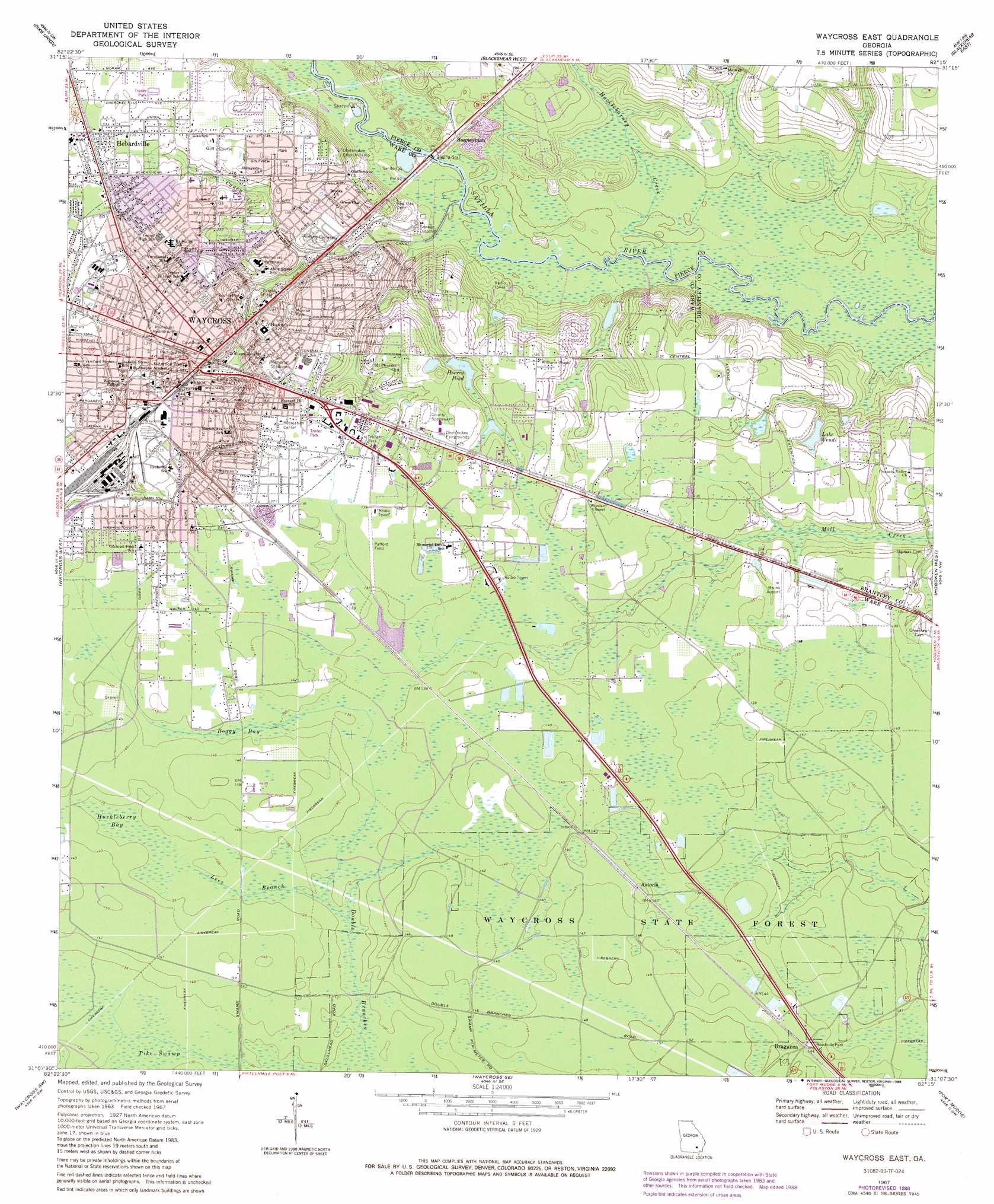
Waycross East Topo Map Georgia
To zoom in, hover over the map of Waycross East
USGS Topo Quad 31082b3 - 1:24,000 scale
| Topo Map Name: | Waycross East |
| USGS Topo Quad ID: | 31082b3 |
| Print Size: | ca. 21 1/4" wide x 27" high |
| Southeast Coordinates: | 31.125° N latitude / 82.25° W longitude |
| Map Center Coordinates: | 31.1875° N latitude / 82.3125° W longitude |
| U.S. State: | GA |
| Filename: | o31082b3.jpg |
| Download Map JPG Image: | Waycross East topo map 1:24,000 scale |
| Map Type: | Topographic |
| Topo Series: | 7.5´ |
| Map Scale: | 1:24,000 |
| Source of Map Images: | United States Geological Survey (USGS) |
| Alternate Map Versions: |
Waycross East GA 1967, updated 1969 Download PDF Buy paper map Waycross East GA 2011 Download PDF Buy paper map Waycross East GA 2014 Download PDF Buy paper map |
1:24,000 Topo Quads surrounding Waycross East
Beach |
Crawley |
Mershon |
Patterson |
Screven |
Talmo |
Dixie Union |
Blackshear West |
Blackshear East |
Patterson Se |
Pine Valley |
Waycross West |
Waycross East |
Hoboken West |
Hoboken East |
Manor |
Waycross Sw |
Waycross Se |
Fort Mudge |
Winokur |
Spooner |
Cravens Island |
Dinner Pond |
Double Lakes |
Newell |
> Back to 31082a1 at 1:100,000 scale
> Back to 31082a1 at 1:250,000 scale
> Back to U.S. Topo Maps home
Waycross East topo map: Gazetteer
Waycross East: Airports
Bivins Airport elevation 39m 127′Memorial Hospital Heliport elevation 34m 111′
Pafford Field elevation 41m 134′
Waycross East: Bridges
Nicks Bridge (historical) elevation 23m 75′Waycross-Blackshear Bridge elevation 23m 75′
Woodwards Bridge (historical) elevation 21m 68′
Waycross East: Canals
City Drainage Canal elevation 34m 111′Waycross East: Channels
Williams Cut elevation 21m 68′Waycross East: Dams
Herrin Pond Dam elevation 36m 118′Waycross East: Parks
Folks Park elevation 38m 124′Memorial Stadium elevation 42m 137′
Monroe Park elevation 35m 114′
Newton Field elevation 42m 137′
Voight Field elevation 31m 101′
Waycross Historic District elevation 40m 131′
Waycross State Forest elevation 45m 147′
Waycross East: Populated Places
Astoria elevation 44m 144′Hebardville elevation 43m 141′
Lakeside Mobile Home Park elevation 42m 137′
Sunnyside elevation 42m 137′
Waycross elevation 39m 127′
Waycross East: Post Offices
Waycross Post Office elevation 41m 134′Waycross East: Reservoirs
Herrin Pond elevation 36m 118′Lake Wendi elevation 34m 111′
Monroe Pond elevation 24m 78′
Waycross East: Streams
Bailey Branch elevation 30m 98′Caney Branch elevation 27m 88′
Double Branches elevation 39m 127′
Hacklebarney Creek elevation 21m 68′
Lees Branch elevation 39m 127′
Waycross East: Swamps
Boggy Bay elevation 42m 137′Huckleberry Bay elevation 41m 134′
Waycross East digital topo map on disk
Buy this Waycross East topo map showing relief, roads, GPS coordinates and other geographical features, as a high-resolution digital map file on DVD: