Broxton North Topo Map Georgia
To zoom in, hover over the map of Broxton North
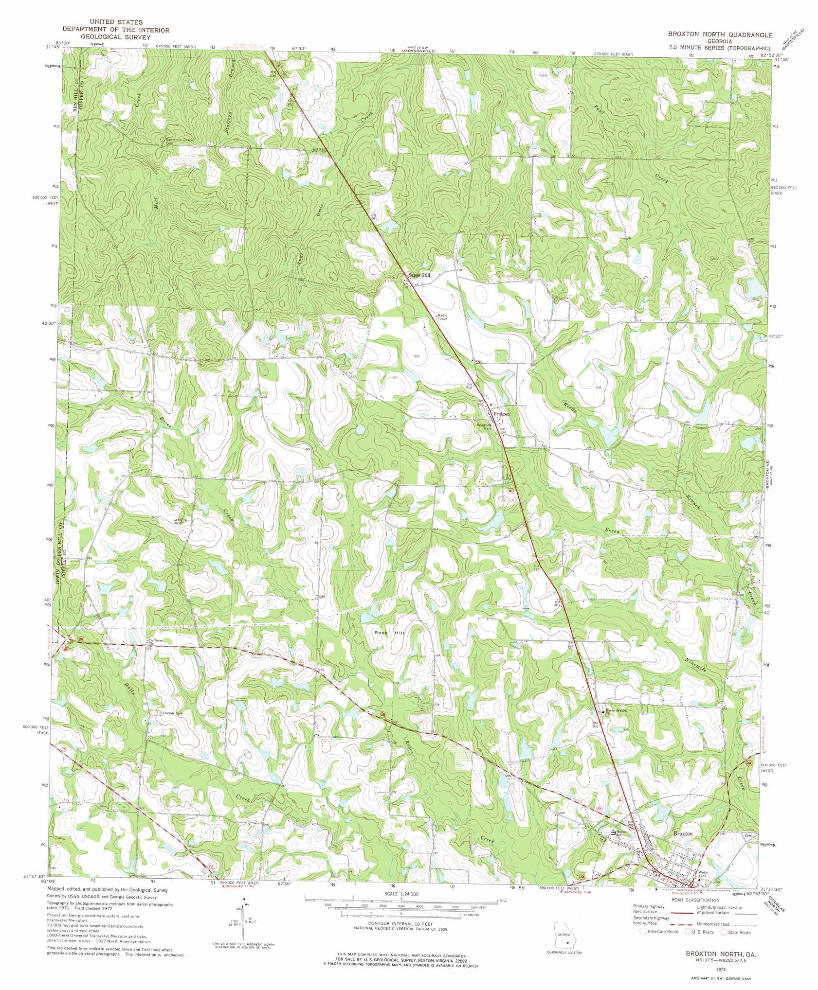
USGS Topo Quad 31082f8 - 1:24,000 scale
| Topo Map Name: | Broxton North |
| USGS Topo Quad ID: | 31082f8 |
| Print Size: | ca. 21 1/4" wide x 27" high |
| Southeast Coordinates: | 31.625° N latitude / 82.875° W longitude |
| Map Center Coordinates: | 31.6875° N latitude / 82.9375° W longitude |
| U.S. State: | GA |
| Filename: | o31082f8.jpg |
| Download Map JPG Image: | Broxton North topo map 1:24,000 scale |
| Map Type: | Topographic |
| Topo Series: | 7.5´ |
| Map Scale: | 1:24,000 |
| Source of Map Images: | United States Geological Survey (USGS) |
| Alternate Map Versions: |
Broxton North GA 1972, updated 1975 Download PDF Buy paper map Broxton North GA 2011 Download PDF Buy paper map Broxton North GA 2014 Download PDF Buy paper map |
1:24,000 Topo Quads surrounding Broxton North
Rhine |
Cooks Still |
Workmore |
Jacksonville Ne |
Lumber City |
Queensland |
China Hill |
Jacksonville |
Snipesville |
Roper |
Fitzgerald East |
Osierfield |
Broxton North |
Broxton Ne |
Denton |
Ocilla East |
Ambrose |
Broxton South |
Douglas North |
Nicholls |
Alapaha |
Lax |
Mora |
Douglas South |
Wilsonville |
> Back to 31082e1 at 1:100,000 scale
> Back to 31082a1 at 1:250,000 scale
> Back to U.S. Topo Maps home
Broxton North topo map: Gazetteer
Broxton North: Dams
Dockery Pond Dam elevation 76m 249′J J Dockery Pond Dam elevation 81m 265′
James Smith Lake Dam elevation 91m 298′
Kight Lake Dam elevation 84m 275′
Reynolds Lake Dam elevation 82m 269′
Sam Jones Lake Dam elevation 85m 278′
Broxton North: Populated Places
Broxton elevation 87m 285′Pridgen elevation 93m 305′
Sapps Still elevation 98m 321′
Broxton North: Reservoirs
Dockery Pond elevation 76m 249′J J Dockery Pond elevation 81m 265′
James Smith Lake elevation 91m 298′
Kight Lake elevation 84m 275′
Reynolds Lake elevation 82m 269′
Sam Jones Lake elevation 85m 278′
Broxton North: Streams
Reedy Branch elevation 73m 239′Broxton North: Summits
Rose Hill elevation 91m 298′Broxton North digital topo map on disk
Buy this Broxton North topo map showing relief, roads, GPS coordinates and other geographical features, as a high-resolution digital map file on DVD: