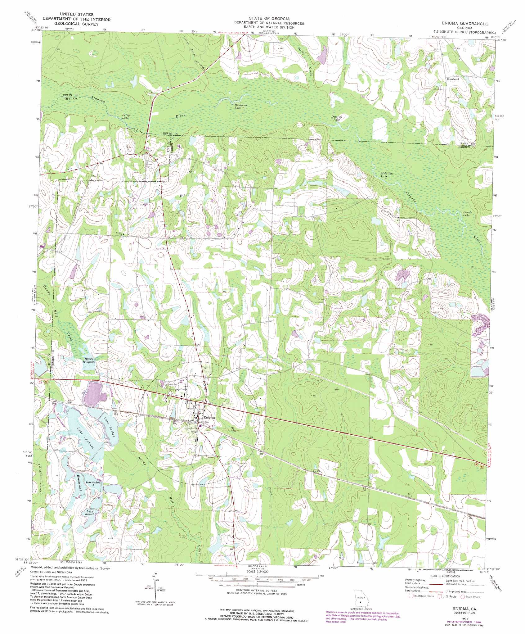
Enigma Topo Map Georgia
To zoom in, hover over the map of Enigma
USGS Topo Quad 31083d3 - 1:24,000 scale
| Topo Map Name: | Enigma |
| USGS Topo Quad ID: | 31083d3 |
| Print Size: | ca. 21 1/4" wide x 27" high |
| Southeast Coordinates: | 31.375° N latitude / 83.25° W longitude |
| Map Center Coordinates: | 31.4375° N latitude / 83.3125° W longitude |
| U.S. State: | GA |
| Filename: | o31083d3.jpg |
| Download Map JPG Image: | Enigma topo map 1:24,000 scale |
| Map Type: | Topographic |
| Topo Series: | 7.5´ |
| Map Scale: | 1:24,000 |
| Source of Map Images: | United States Geological Survey (USGS) |
| Alternate Map Versions: |
Enigma GA 1973, updated 1976 Download PDF Buy paper map Enigma GA 1973, updated 1988 Download PDF Buy paper map Enigma GA 2011 Download PDF Buy paper map Enigma GA 2014 Download PDF Buy paper map |
1:24,000 Topo Quads surrounding Enigma
Bethel |
Irwinville |
Fitzgerald West |
Fitzgerald East |
Osierfield |
Chula |
Waterloo |
Ocilla West |
Ocilla East |
Ambrose |
Tifton West |
Tifton East |
Enigma |
Alapaha |
Lax |
Omega |
Lenox |
Sapps Lake |
Tenmile Bay |
Willacoochee |
Ellenton |
Adel |
Nashville West |
Nashville East |
Hastings Fish Pond |
> Back to 31083a1 at 1:100,000 scale
> Back to 31082a1 at 1:250,000 scale
> Back to U.S. Topo Maps home
Enigma topo map: Gazetteer
Enigma: Dams
Hardy Millpond Dam elevation 87m 285′Horseshoe Five Lake Dam elevation 87m 285′
Horseshoe Four Lake Dam elevation 90m 295′
Lake Bobben Dam elevation 84m 275′
Lake Patrick Dam elevation 87m 285′
Lake Russell Dam elevation 93m 305′
Martin Lake Dam elevation 81m 265′
McCrain Lake Dam elevation 91m 298′
Spurlock Lake Dam elevation 87m 285′
Enigma: Lakes
Dominy Lake elevation 73m 239′Ferry Lake elevation 75m 246′
Hammock Lake elevation 73m 239′
Horseshoe 4 elevation 90m 295′
Horseshoe 5 elevation 87m 285′
Lake Bobben elevation 84m 275′
Lake Patrick elevation 87m 285′
Lake Russel elevation 93m 305′
McMillan Lake elevation 72m 236′
Purvis Lake elevation 71m 232′
Enigma: Populated Places
Enigma elevation 93m 305′Riverbend elevation 99m 324′
Enigma: Reservoirs
Hardy Millpond elevation 87m 285′Horsehsoe S Lake elevation 85m 278′
Horseshoe A Lake elevation 87m 285′
Lake Bobben elevation 84m 275′
Lake Patrick elevation 87m 285′
Lake Russell elevation 87m 285′
Martin Lake elevation 81m 265′
McCrain Lake elevation 91m 298′
Spurlock Lake elevation 87m 285′
Enigma: Streams
Big Branch elevation 76m 249′Camp Branch elevation 92m 301′
Gum Creek elevation 80m 262′
Island Field Branch elevation 75m 246′
Mill Creek elevation 73m 239′
Enigma digital topo map on disk
Buy this Enigma topo map showing relief, roads, GPS coordinates and other geographical features, as a high-resolution digital map file on DVD: